User:Hurricane Noah/Tropical cyclone intensity
Structure
[edit]Eye and center
[edit]
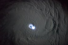
At the center of a mature tropical cyclone, air sinks rather than rises. For a sufficiently strong storm, air may sink over a layer deep enough to suppress cloud formation, thereby creating a clear "eye". Weather in the eye is normally calm and free of convective clouds, although the sea may be extremely violent.[1] The eye is normally circular and is typically 30–65 km (19–40 mi) in diameter, though eyes as small as 3 km (1.9 mi) and as large as 370 km (230 mi) have been observed.[2][3] In a weaker storm, the eye may be obscured by the central dense overcast, which is the upper-level cirrus shield that is associated with a concentrated area of strong thunderstorm activity near the center of a tropical cyclone.[4]
The cloudy outer edge of the eye is called the "eyewall". The eyewall typically expands outward with height, resembling an arena football stadium; this phenomenon is sometimes referred to as the "stadium effect".[3] The eyewall is where the greatest wind speeds are found, air rises most rapidly, clouds reach their highest altitude, and precipitation is the heaviest. The heaviest wind damage occurs where a tropical cyclone's eyewall passes over land.[1]
The eyewall may vary over time in the form of eyewall replacement cycles, particularly in intense tropical cyclones. Outer rainbands can organize into an outer ring of thunderstorms that slowly moves inward, which is believed to rob the primary eyewall of moisture and angular momentum. When the primary eyewall weakens, the tropical cyclone weakens temporarily. The outer eyewall eventually replaces the primary one at the end of the cycle, at which time the storm may return to its original intensity.[5]
Rainbands
[edit]Clouds
[edit]- ^ a b National Weather Service (October 19, 2005). "Tropical Cyclone Structure". JetStream – An Online School for Weather. National Oceanic & Atmospheric Administration. Archived from the original on December 7, 2013. Retrieved May 7, 2009.
- ^ Pasch, Richard J.; Eric S. Blake; Hugh D. Cobb III; David P. Roberts (September 28, 2006). "Tropical Cyclone Report: Hurricane Wilma: 15–25 October 2005" (PDF). National Hurricane Center. Archived (PDF) from the original on March 4, 2016. Retrieved December 14, 2006.
- ^ a b Annamalai, H.; Slingo, J.M.; Sperber, K.R.; Hodges, K. (1999). "The Mean Evolution and Variability of the Asian Summer Monsoon: Comparison of ECMWF and NCEP–NCAR Reanalyses". Monthly Weather Review. 127 (6): 1157–1186. Bibcode:1999MWRv..127.1157A. doi:10.1175/1520-0493(1999)127<1157:TMEAVO>2.0.CO;2. Archived from the original on August 1, 2020. Retrieved December 12, 2019.
- ^ American Meteorological Society. "AMS Glossary: C". Glossary of Meteorology. Allen Press. Archived from the original on January 26, 2011. Retrieved December 14, 2006.
- ^ Atlantic Oceanographic and Hurricane Research Division. "Frequently Asked Questions: What are "concentric eyewall cycles" (or "eyewall replacement cycles") and why do they cause a hurricane's maximum winds to weaken?". National Oceanic and Atmospheric Administration. Archived from the original on December 6, 2006. Retrieved December 14, 2006.
