Jump to content

User:Hike395/test mountain bot 3

From Wikipedia, the free encyclopedia

Mount St. Helens

[edit]
Before After
Mount St. Helens
3,000 ft (1 km) high steam plume on May 19, 1982, two years after its major eruption
Highest point
Elevation8,363 ft (2,549 m)
Prominence4,605 ft (1,404 m)
Listing
Coordinates46°11′28″N 122°11′40″W / 46.1912000°N 122.1944000°W / 46.1912000; -122.1944000[1]
Naming
Native name
Geography
Mount St. Helens is located in Washington (state)
Mount St. Helens
Mount St. Helens
Parent rangeCascade Range
Topo mapUSGS Mount St. Helens
Geology
Rock age< 40,000 yrs
Mountain typeActive stratovolcano (Subduction zone)
Volcanic arcCascade Volcanic Arc
Last eruption2004–2008
Climbing
First ascent1853 by Thomas J. Dryer
Easiest routeHike via south slope of volcano (closest area near eruption site)
Mount St. Helens
3,000 ft (1 km) high steam plume on May 19, 1982, two years after its major eruption
Highest point
Elevation8,363 ft (2,549 m)
Prominence4,605 ft (1,404 m)
Listing
Coordinates46°11′28″N 122°11′40″W / 46.1912000°N 122.1944000°W / 46.1912000; -122.1944000[1]
Naming
Native name
Geography
Mount St. Helens is located in Washington (state)
Mount St. Helens
Mount St. Helens
Parent rangeCascade Range
Topo mapUSGS Mount St. Helens
Geology
Rock age< 40,000 yrs
Mountain typeActive stratovolcano (Subduction zone)
Volcanic regionCascade Volcanic Arc
Last eruption2004–2008
Climbing
First ascent1853 by Thomas J. Dryer
Easiest routeHike via south slope of volcano (closest area near eruption site)

Mount Vesuvius

[edit]
Before After
Mount Vesuvius
Mount Vesuvius as seen from the ruins of Pompeii, which was destroyed in the eruption of AD 79. The active cone is the high peak on the left side; the smaller one on the right is part of the Somma caldera wall.
Highest point
Coordinates40°49′N 14°26′E / 40.817°N 14.433°E / 40.817; 14.433
Naming
Native nameMonte Vesuvio (Italian)
Muntagna Vesuvio (Neapolitan) Error {{native name checker}}: list markup expected for multiple names (help)
Geography
Geology
Rock age25,000 years before present to 1944; age of volcano = c. 17,000 years to present
Mountain typeSomma-stratovolcano
Volcanic arc/beltCampanian volcanic arc
Last eruption17–23 March 1944
Climbing
Easiest routeWalk
Mount Vesuvius
Mount Vesuvius as seen from the ruins of Pompeii, which was destroyed in the eruption of AD 79. The active cone is the high peak on the left side; the smaller one on the right is part of the Somma caldera wall.
Highest point
Coordinates40°49′N 14°26′E / 40.817°N 14.433°E / 40.817; 14.433
Naming
Native nameMonte Vesuvio (Italian)
Muntagna Vesuvio (Neapolitan) Error {{native name checker}}: list markup expected for multiple names (help)
Geography
Geology
Rock age25,000 years before present to 1944; age of volcano = c. 17,000 years to present
Mountain typeSomma-stratovolcano
Volcanic regionCampanian volcanic arc
Last eruption17–23 March 1944
Climbing
Easiest routeWalk

Mount Pinatubo

[edit]
Before After
Mount Pinatubo
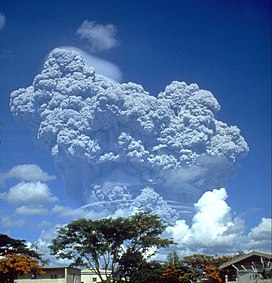
The eruption column of Mount Pinatubo on June 12, 1991, three days before the climactic eruption
Highest point
Elevation
  • 1,486 m (4,875 ft) (current)
  • 1,745 m (5,725 ft) (before 1991 eruption)
ListingList of active volcanoes in the Philippines
Coordinates15°08′30″N 120°21′00″E / 15.14167°N 120.35000°E / 15.14167; 120.35000
Naming
Language of nameFilipino
Pronunciation/ˌpnəˈtb/
Geography
Mount Pinatubo is located in Philippines
Mount Pinatubo
Mount Pinatubo
Location within the Philippines
LocationLuzon
CountryPhilippines
RegionCentral Luzon
Provinces
Parent rangeZambales Mountains
Geology
Rock age(s)Between 635,000 ± 80,000
and 1.1 ± 0.09 million years[2]
Mountain typeStratovolcano[3]
Volcanic arc/beltLuzon Volcanic Arc
Last eruption1991[3]
Map
Mount Pinatubo
The eruption column of Mount Pinatubo on June 12, 1991, three days before the climactic eruption
Highest point
Elevation
  • 1,486 m (4,875 ft) (current)
  • 1,745 m (5,725 ft) (before 1991 eruption)
ListingList of active volcanoes in the Philippines
Coordinates15°08′30″N 120°21′00″E / 15.14167°N 120.35000°E / 15.14167; 120.35000
Naming
Language of nameFilipino
Pronunciation/ˌpnəˈtb/
Geography
Mount Pinatubo is located in Philippines
Mount Pinatubo
Mount Pinatubo
Location within the Philippines
LocationLuzon
CountryPhilippines
RegionCentral Luzon
Provinces
Parent rangeZambales Mountains
Geology
Rock age(s)Between 635,000 ± 80,000
and 1.1 ± 0.09 million years[4]
Mountain typeStratovolcano[3]
Volcanic regionLuzon Volcanic Arc
Last eruption1991[3]
Map

Denali

[edit]
Before After
Denali
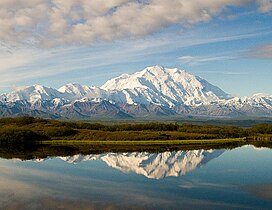
A snow-covered, gently sloping mountain is in the background, with a lake in the foreground
From the north, with Reflection Pond in the foreground
Highest point
Elevation20,310 ft (6190 m) top of snow[5][6]
NAVD88
Prominence20,146 ft (6140 m)[7]
Isolation4629 mi (7450 km)[7]
Listing
Coordinates63°04′10″N 151°00′27″W / 63.0695°N 151.0074°W / 63.0695; -151.0074[1]
Geography
Denali is located in Alaska
Denali
Denali
LocationDenali National Park and Preserve, Alaska, U.S.
Parent rangeAlaska Range
Topo mapUSGS Mt. McKinley A-3
Climbing
First ascentJune 7, 1913 by
Easiest routeWest Buttress Route (glacier/snow climb)
Denali
A snow-covered, gently sloping mountain is in the background, with a lake in the foreground
From the north, with Reflection Pond in the foreground
Highest point
Elevation20,310 ft (6,190 m) top of snow[5][6]
NAVD88
Prominence20,146 ft (6,141 m)[7]
Isolation4,629 mi (7,450 km)[7]
Listing
Coordinates63°04′10″N 151°00′27″W / 63.0695°N 151.0074°W / 63.0695; -151.0074[1]
Geography
Denali is located in Alaska
Denali
Denali
LocationDenali National Park and Preserve, Alaska, U.S.
Parent rangeAlaska Range
Topo mapUSGS Mt. McKinley A-3
Climbing
First ascentJune 7, 1913 by
Easiest routeWest Buttress Route (glacier/snow climb)

Taal Volcano

[edit]
Before After
Taal Volcano
Bulkang Taal
Aerial photo of Volcano Island within Taal Volcano, taken in 2012. North is to the right-hand side.
Highest point
Elevation311 m (1,020 ft)[8]
Coordinates14°0′36″N 120°59′51″E / 14.01000°N 120.99750°E / 14.01000; 120.99750
Geography
Taal Volcano is located in Philippines
Taal Volcano
Taal Volcano
Location in the Philippines
LocationTalisay and San Nicolas Batangas, Philippines
Geology
Mountain typeCaldera[8]
Volcanic arc/beltLuzon Volcanic Arc
Last eruptionJanuary 12, 2020
Climbing
Easiest routeDaang Kastila (Spanish Trail)
Map
An interactive map of Taal Volcano
Taal Volcano
Bulkang Taal
Aerial photo of Volcano Island within Taal Volcano, taken in 2012. North is to the right-hand side.
Highest point
Elevation311 m (1,020 ft)[8]
Coordinates14°0′36″N 120°59′51″E / 14.01000°N 120.99750°E / 14.01000; 120.99750
Geography
Taal Volcano is located in Philippines
Taal Volcano
Taal Volcano
Location in the Philippines
LocationTalisay and San Nicolas Batangas, Philippines
Geology
Mountain typeCaldera[8]
Volcanic regionLuzon Volcanic Arc
Last eruptionJanuary 12, 2020
Climbing
Easiest routeDaang Kastila (Spanish Trail)
Map
An interactive map of Taal Volcano

Uluru

[edit]
Before After
Uluru
Ayers Rock
2007 aerial view of Uluru
Highest point
Elevation863 m (2,831 ft)
Prominence348 m (1,142 ft)
Coordinates25°20′42″S 131°02′10″E / 25.34500°S 131.03611°E / -25.34500; 131.03611
Naming
Native nameUluṟu Error {{native name checker}}: parameter value is malformed (help)
Geography
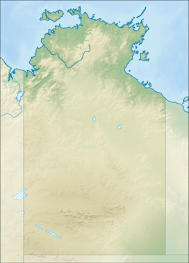
Uluru is located in Northern Territory
Uluru
Uluru
Uluru is located in Australia
Uluru
Uluru
Uluru (Australia)
Geology
Rock age550–530 Ma
Mountain typeInselberg
Rock typeArkose
Official nameUluṟu-Kata Tjuṯa National Park
Criteriav,vi,vii,ix
Reference447
Inscription1987 (11th Session)
Uluru
Ayers Rock
2007 aerial view of Uluru
Highest point
Elevation863 m (2,831 ft)
Prominence348 m (1,142 ft)
Coordinates25°20′42″S 131°02′10″E / 25.34500°S 131.03611°E / -25.34500; 131.03611
Naming
Native nameUluṟu Error {{native name checker}}: parameter value is malformed (help)
Geography
Uluru is located in Northern Territory
Uluru
Uluru
Uluru is located in Australia
Uluru
Uluru
Uluru (Australia)
Geology
Rock age550–530 Ma
Mountain typeInselberg
Rock typeArkose
Official nameUluṟu-Kata Tjuṯa National Park
Criteriav,vi,vii,ix
Reference447
Inscription1987 (11th Session)

Mount Kailash

[edit]
Before After
Mount Kailash
Mount Kailash from the south
Highest point
Elevation6,638 m (21,778 ft)
Prominence1,319 m (4,327 ft)
Coordinates31°4′0″N 81°18′45″E / 31.06667°N 81.31250°E / 31.06667; 81.31250
Naming
Native nameགངས་རིན་པོ་ཆེ Error {{native name checker}}: parameter value is malformed (help)
Geography
CountryChina
Parent rangeGangdisê Range
Climbing
First ascentUnclimbed

Mount Olympus

[edit]
Before After
Mount Olympus
Highest point
PeakMytikas
Elevation2,917 m (9,570 ft)[9][10]
Prominence2,353 m (7,720 ft)[11]
Parent peakMusala
ListingCountry high point
Ultra
Coordinates40°05′08″N 22°21′31″E / 40.08556°N 22.35861°E / 40.08556; 22.35861
Geography
Mount Olympus is located in Greece
Mount Olympus
Mount Olympus
Location of Mount Olympus
LocationGreece
Parent rangeMacedonia and Thessaly, near the Gulf of Salonika
Climbing
First ascent2 August 1913
Christos Kakkalos, Frederic Boissonnas and Daniel Baud-Bovy
Mount Olympus
Highest point
PeakMytikas
Elevation2,917 m (9,570 ft)[12][10]
Prominence2,353 m (7,720 ft)[11]
Parent peakMusala
ListingCountry high point
Ultra
Coordinates40°05′08″N 22°21′31″E / 40.08556°N 22.35861°E / 40.08556; 22.35861
Geography
Mount Olympus is located in Greece
Mount Olympus
Mount Olympus
Location of Mount Olympus
LocationGreece
Parent rangeMacedonia and Thessaly, near the Gulf of Salonika
Climbing
First ascent2 August 1913
Christos Kakkalos, Frederic Boissonnas and Daniel Baud-Bovy

Krakatoa

[edit]
Before After
Krakatoa
Highest point
ListingSpesial Ribu
Coordinates6°06′07″S 105°25′23″E / 6.102°S 105.423°E / -6.102; 105.423
Naming
Native nameKrakatau Error {{native name checker}}: parameter value is malformed (help)
Geography
Krakatoa is located in Indonesia
Krakatoa
Krakatoa
Location within Indonesia
LocationIndonesia
Geology
Mountain typeCaldera
Last eruption2020[13]
Krakatoa
Highest point
ListingSpesial Ribu
Coordinates6°06′07″S 105°25′23″E / 6.102°S 105.423°E / -6.102; 105.423
Naming
Native nameKrakatau Error {{native name checker}}: parameter value is malformed (help)
Geography
Krakatoa is located in Indonesia
Krakatoa
Krakatoa
Location within Indonesia
LocationIndonesia
Geology
Mountain typeCaldera
Last eruption2020[14]

Mount Ararat

[edit]
Before After
Mount Ararat

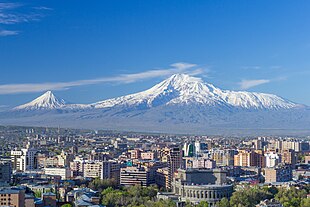
Little Ararat (left) and Greater Ararat (right); View from Yerevan, Armenia
Highest point
Elevation5,137 m (16,854 ft)
See Elevation section
Prominence3,611 m (11,847 ft)[15]
Ranked 48th
ListingCountry high point
Ultra
Volcanic Seven Second Summits
Coordinates39°42.113′N 44°17.899′E / 39.701883°N 44.298317°E / 39.701883; 44.298317[16]
Naming
Native nameAğrı Dağı (Turkish)
Մասիս/Արարատ (Armenian) Error {{native name checker}}: list markup expected for multiple names (help)
Geography
Mount Ararat is located in Turkey
Mount Ararat
Mount Ararat
Location in Turkey
Mount Ararat is located in Asia
Mount Ararat
Mount Ararat
Mount Ararat (Asia)
Mount Ararat is located in Earth
Mount Ararat
Mount Ararat
Mount Ararat (Earth)
LocationIğdır and Ağrı provinces, Turkey
RegionEastern Anatolia Region
Parent rangeArmenian Highlands
Geology
Mountain typeStratovolcano
Last eruptionJuly 2, 1840
Climbing
First ascent9 October [O.S. 27 September] 1829
Friedrich Parrot, Khachatur Abovian, two Russian soldiers, two Armenian villagers
Mount Ararat

Little Ararat (left) and Greater Ararat (right); View from Yerevan, Armenia
Highest point
Elevation5,137 m (16,854 ft)
See Elevation section
Prominence3,611 m (11,847 ft)[17]
Ranked 48th
ListingCountry high point
Ultra
Volcanic Seven Second Summits
Coordinates39°42.113′N 44°17.899′E / 39.701883°N 44.298317°E / 39.701883; 44.298317[18]
Naming
Native nameAğrı Dağı (Turkish)
Մասիս/Արարատ (Armenian) Error {{native name checker}}: list markup expected for multiple names (help)
Geography
Mount Ararat is located in Turkey
Mount Ararat
Mount Ararat
Location in Turkey
Mount Ararat is located in Asia
Mount Ararat
Mount Ararat
Mount Ararat (Asia)
Mount Ararat is located in Earth
Mount Ararat
Mount Ararat
Mount Ararat (Earth)
LocationIğdır and Ağrı provinces, Turkey
State/ProvinceEastern Anatolia Region
Parent rangeArmenian Highlands
Geology
Mountain typeStratovolcano
Last eruptionJuly 2, 1840
Climbing
First ascent9 October [O.S. 27 September] 1829
Friedrich Parrot, Khachatur Abovian, two Russian soldiers, two Armenian villagers
  1. ^ a b c d "Mount Saint Helens". Geographic Names Information System. United States Geological Survey, United States Department of the Interior.
  2. ^ "Pinatubo Volcano". The Philippine Institute of Volcanology and Seismology (PHIVOLCS). Archived from the original on January 29, 2009. Retrieved August 12, 2008.
  3. ^ a b c d "Pinatubo". Global Volcanism Program. Smithsonian Institution. Retrieved January 23, 2020.
  4. ^ "Pinatubo Volcano". The Philippine Institute of Volcanology and Seismology (PHIVOLCS). Archived from the original on January 29, 2009. Retrieved August 12, 2008.
  5. ^ a b Mark Newell; Blaine Horner (September 2, 2015). "New Elevation for Nation's Highest Peak" (Press release). USGS. Retrieved May 16, 2016.
  6. ^ a b Wagner, Mary Jo (November 2015). "Surveying at 20,000 feet". The American Surveyor. 12 (10): 10–19. ISSN 1548-2669.
  7. ^ a b c d "Denali, Alaska". Peakbagger.com. Retrieved December 12, 2015.
  8. ^ a b c d "Taal". Global Volcanism Program. Smithsonian Institution. Retrieved February 13, 2013. Cite error: The named reference "gvp" was defined multiple times with different content (see the help page).
  9. ^ Mount Olympus | mountain, Greece | Britannica
  10. ^ a b Cite error: The named reference np was invoked but never defined (see the help page).
  11. ^ a b "Olympus, Greece". Peakbagger.com. Cite error: The named reference "pb" was defined multiple times with different content (see the help page).
  12. ^ Mount Olympus | mountain, Greece | Britannica
  13. ^ "Global Volcanism Program | Krakatau". Smithsonian Institution | Global Volcanism Program.
  14. ^ "Global Volcanism Program | Krakatau". Smithsonian Institution | Global Volcanism Program.
  15. ^ "100 World Mountains ranked by primary factor". ii.uib.no. Institutt for informatikk University of Bergen. Archived from the original on 2016-05-21. Retrieved 2016-05-09.
  16. ^ Bjørstad, Petter E. (August 2007). "Ararat Trip Report". ii.uib.no. University of Bergen. Archived from the original on 21 October 2017.
  17. ^ "100 World Mountains ranked by primary factor". ii.uib.no. Institutt for informatikk University of Bergen. Archived from the original on 2016-05-21. Retrieved 2016-05-09.
  18. ^ Bjørstad, Petter E. (August 2007). "Ararat Trip Report". ii.uib.no. University of Bergen. Archived from the original on 21 October 2017.