User:Gryphonis/Sandbox
Appearance
Oslo | |
|---|---|
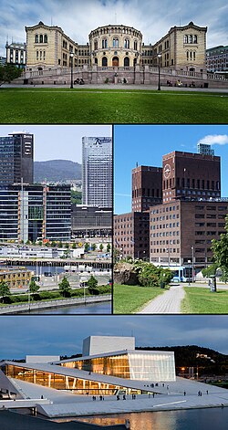
 Top: Parliament of Norway Building, middle left: Bjørvika, middle right: Oslo City Hall seen from Akershus Castle, bottom: Oslo Opera House | |
| Motto(s): Unanimiter et constanter (Latin: United and constant) | |
| Coordinates: 59°56′58″N 10°45′23″E / 59.94944°N 10.75639°E | |
| Country | Norway |
| District | Østlandet |
| County | Oslo |
| Municipality | Oslo |
| Established | 1048 |
| Government | |
| • Mayor | Fabian Stang (H) |
| • Governing mayor | Stian Berger Røsland (H) |
| Area | |
| • Urban | 285.26 km2 (110.14 sq mi) |
| • Metro | 9,444.9 km2 (3,646.7 sq mi) |
| Highest elevation | 600 m (2,000 ft) |
| Lowest elevation | 1 m (3 ft) |
| Population (July 2011)[6] | |
| • Rank | 1 of 430 |
| • Metro | 607,292 |
| Ethnic groups | |
| • Norwegians | 71.5% |
| • Pakistanis | 3.6% |
| • Somalis | 2.0% |
| • Swedes | 2.0% |
| • Poles | 1.7% |
| Time zone | UTC+1 (CET) |
| • Summer (DST) | UTC+2 (CEST) |
| Website | www |
ref
[edit]- ^ "Arealstatistikk - gir informasjon om arealer i kommuner og fylker". Norwegian Mapping and Cadastre Authority (in Norwegian). 1 January 2010.
{{cite web}}: Unknown parameter|trans_title=ignored (|trans-title=suggested) (help) - ^ urban footnotes
- ^ Metro footnotes
- ^ elevation max footnotes
- ^ elevation min footnotes
- ^ "Folkemengde etter kommune". Statistics Norway (in Norwegian). 1 July 2011.
{{cite web}}: Unknown parameter|trans_title=ignored (|trans-title=suggested) (help) - ^ "Immigrants and Norwegian-born to immigrant parents by country of birth1,(the 20 largest groups).Selected municipalities.1 January 2011". Statistics Norway. Retrieved 28 April 2011.
- ^ elevation footnotes
test
[edit]607292TestTemplate1|0301
1457607TestTemplate1|M0301
454TestTemplate1|0301
426.3TestTemplate1|0301L
27.7TestTemplate1|0301W
6.1TestTemplate1|0301P
test2
[edit]454tester0301


