User:GarrettGissinger/sandbox


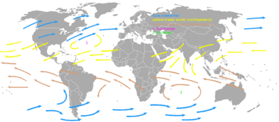
Global wind patterns: The globe is encircled by six major wind belts, three in each hemisphere. From pole to equator they are the polar easterlies, the westerlies and the trade winds. All six belts move north in the northern summer and south in the northern winter.
Categories
[edit]Polar Easterlies: At about the latitude of Norway and northward (60-90 degrees) the Polar easterlies blow irregularly from the east and north.
Polar Front: Between the polar easterlies and the westerlies is the polar front.
Westerlies: At about the latitude of Western Europe and the United States (30-60 degrees) the Westerlies blow from the west, tending somewhat toward the north. This causes most weather in the United States to move from west to east.
Horse Latitudes: Where the Westerlies meet the trade winds at about 30 degrees (Jacksonville, Florida) is the Horse latitudes, also Variables of Cancer, Subtropical High or Subtropical ridge. This is a region of high pressure, dry air and variable winds and is associated with deserts over land.
Trade Winds: South of about 30 degrees the northern or northeast trade winds blow mostly from the northeast toward the equator. These were the sailor's favorite winds since the weather was warm and the winds usually blew steadily in an advantageous direction. Columbus used these to sail to the Caribbean.
Doldrums: At about the equator is Intertropical Convergence Zone or doldrums, a region of light and irregular wind broken by occasional thunderstorms and squalls. The width and exact location of the doldrums is hard to predict. Sailing ships are sometimes becalmed here for many days waiting for a proper wind.
Other Winds
[edit]Southern hemisphere: In the southern hemisphere the belts are reversed. The southeast trade winds blow from the southeast toward the equator. The southern equivalent of the horse latitudes (or Variables of Cancer) is called the Variables of Capricorn. The southern westerlies start somewhat south of South Africa. They tend to be stronger than the northern westerlies because they are mostly over water (roaring forties). The southern polar easterlies are mostly over Antarctica.
Land and sea breezes: Land gains and loses heat more rapidly than water. During the day the land warms more rapidly than the water. The air above land warms, becomes thinner and rises drawing cooler air landward from the sea. At night the process reverses and cool heavy air from the land flows out to sea. These land and sea breezes are important along the coast.

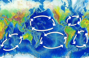
Ocean Gyre: The fact that the westerlies and trade winds blow in opposite directions and that the continents prevent water from circling the globe contributes to the formation of circular ocean currents, clockwise in the northern hemisphere and counterclockwise in the southern hemisphere. The Coriolis force also plays a part. The trade winds push water west. At the doldrums it flows back east producing the equatorial countercurrent. See Ocean gyre.
Coriolis force, Hadley cell and other things: In the northern hemisphere the Coriolis effect causes wind and water currents to bend to the right (clockwise). Cold heavy air flows south from the north pole and is bent west, forming the polar easterlies. Warm air rises at the equator drawing air from the north which bends to the west, contributing to the trade winds. The Coriolis effect bends the westerlies and trade winds slightly clockwise in the northern hemisphere.
Hot air rises at the doldrums. As it rises it cools producing thunderstorms. The dry air flows north at a high altitude and descends at the horse latitudes and flows back to the equator with the trade winds. This is called the Hadley cell. There is also a Ferrel cell over the westerlies and a polar cell over the pole. There are other complexities, not all of which are properly understood.
Jet streams are narrow bands of strong wind in the upper portions of the atmosphere. They blow from west to east but the flow frequently shifts to the north and south. Jet streams follow boundaries between hot and cold air, which means jet streams are strongest during winter for both the northern and southern hemispheres.[1]
Trends in Global Wind Patterns
[edit]Seasonal shifts: All of the belts move north during the northern summer and south during the northern winter. Because global heating and cooling lags behind the position of the sun they reach their northernmost latitude at or after the end of the northern summer. This brought the trade winds within reach of the Spain and Portugal and determined the sailing time of the Spanish treasure fleet. The northernmost position of the wind belts corresponds to the Atlantic hurricane season.
Historic Trends
[edit]At the peak of the last ice age, the westerlies were too far north to be aligned with the Antarctic Circumpolar Current and could not draw much mid-depth water to the surface. At the end of the ice age, there was a southward shift in the westerlies, because there was no longer a large temperature difference between the Northern and Southern hemispheres. The westerlies’ southern shift drew more CO2 and silica-rich water up the surface because they were now aligned better with the Antarctic Circumpolar Current.[2]
Modern Trends
[edit]The westerlies have strengthened and shifted poleward over the past 50 years. This shift may be in response higher global average temperatures caused by rising concentrations of atmospheric carbon dioxide.[2] The Pacific equatorial trade winds strengthened in the early and mid-1930’s, weakened from the late 1930s to late 1950s, strengthened during the 1960s, and have weakened since.[3]
“Wind speeds over the majority of the world’s oceans have increased by at least .25 to .5% per year ( a 5 to 10% increase over the past 20 years). The trend is stronger in the Southern Hemisphere than in the Northern Hemisphere. The only significant exception to this positive trend is the central north Pacific, where there are smaller, localized increases in wind speed of approximately .25% per year or a weak negative trend in some areas.”[4]
Effects of Global Wind Patterns
[edit]Effects on Transportation
[edit]Historic
[edit]Before the ninth century, Arab sailors were relying on the monsoon winds of the northern Indian Ocean to cross over to northeastern Africa and the Middle East to China. The monsoon winds blew from the southwest in the summer and from the northeast in the winter. During the early 1400’s, the Portuguese struggled against the Atlantic Ocean’s east to west trade winds so they could get around Africa and access India and China. Christopher Columbus used the east to west trade winds to cross the Atlantic Ocean to the Caribbean Sea. At the latitude around the modern North Carolina, the Spanish found winds generally blowing toward the east. These were the westerlies, and they returned sailors to Europe.[5]
Modern
[edit]By the nineteenth century, using the trade winds to guide one’s ship had become rare because routes were definite and marked down on maps. Today, sailing is rarely used to trade goods. If sailing is used for non-recreational transport, GPS is often used also. However, using wind patterns as a method of direction still is influential in international travel and trade. [6]
Effects on Wildlife
[edit]The southern westerlies can alter the oceanic circulation by better aligning with the Antarctic Circumpolar Current. This draws the mid-depth water from north of the ACC to the surface around Antarctica and vents CO2 and silica-rich water to the top of the ocean. [2]
A study on the correlation between wind speeds and Chl-a concentrations was conducted for the Journal of Geophysical Research. They concluded, “For most of the global ocean, high positive correlations between wind speed and Chl-a concentrations occur in regions where the ocean mixed layer is comparatively shallow, and increased winds are readily able to deepen the mixed layer and entrain additional nutrients into the upper ocean. Strong negative correlations tend to occur in regions where late winter mixed layers are deep, and increased winds are likely to deepen the mixed layer enough to push phytoplankton out of the sunlit euphotic zone at the top of the ocean. Because of these distinctions between regions where increased winds appear to reduce light and regions where increased winds appear to increase nutrient availability, regions of strong positive and negative correlation map out distinct biogeochemical regimes within the world's oceans.”[7]
Effects on Weather
[edit]Between each of the three circulation cells (Hadley, Ferrel, and Polar) are bands of high and low pressures at the Earth’s surface. The high pressure band is located about 30 degrees N/S latitude and at each pole. The low pressure bands exist at the equator and at 50°-60° N/S. In most cases, fair weather and dry, hot weather is associated with high pressure. Rainy and stormy weather is associated with low pressure. These associations explain why more deserts exist along the 30° N/S latitude, and the region between 50°-60° N/S latitude tends to have more precipitation.[8]
Influential Thinkers
[edit]English astronomer Edmond Halley (1656-1742) attempted to explain the trade winds in 1686. Halley argued the sun’s heat on the equator caused the air in that area to rise. The trade winds are formed by air flowing from the north and south that replace the heated air. In 1735, English Lawyer and scientist George Hadley (1685-1768) proposed a global circulation theory that, unlike Halley’s, accounted for the trade winds blowing from the northeast and southeast. He said the winds do begin blowing directly from the north and south, but the Earth’s rotation turns the winds more northeast and southeast. Hadley saw atmospheric circulation as a cell, with air rising near the equator, traveling high in the atmosphere toward north and south, then sinking in the Arctic and Antarctic and traveling back to the equator along the surface. While Hadley was correct about global winds sinking at the poles, global wind patterns are far more complex high in the atmosphere and at the surface than he imagined.[5]
- ^ [National Weather Service. (2008). The Jet Stream. JetStream - Online School for Weather. Retrieved from: http://www.srh.noaa.gov/jetstream/global/jet.htm]
- ^ a b c [Toggweiler, J.R. (March 13, 2009). Shifting Westerlies. Science, Vol. 323 no. 5920 pp. 1434-1435. Retrieved from http://www.sciencemag.org/content/323/5920/1434 ]
- ^ [Clarke A. J. Lebedev A. (1995) Long-Term Changes in the Equatorial Pacific Trade Winds. Journal of Climate. Volume 9. Retrieved from: http://journals.ametsoc.org/doi/pdf/10.1175/1520-0442%281996%29009%3C1020%3ALTCITE%3E2.0.CO%3B2]
- ^ [ Young, I. R., Zieger, S., Babanin A. V. (March 24, 2011). Global Trends in Wind Speed and Wave Height. Science, Vol. 332 no. 6028 pp. 451-455. Retrieved from http://www.sciencemag.org/content/332/6028/451]
- ^ a b [Williams, J. (2009). The AMS Weather Book, The Ultimate Guide to America’s Weather. Chicago, IL: University of Chicago Press]
- ^ [Heidi, N. (2012) Early European Sailors and the Trade Winds. Humanities. Retrieved from: http://www.humanities360.com/index.php/early-european-sailors-and-the-trade-winds-2-8554/]
- ^ [Kahru, M. Gille, S. T. Murtugudde, R. Strutton, P.G. Manzano-Sarabia, M. Wang, H. Mitchell, B. G. (2010). Global correlations between winds and ocean chlorophyll. Journal of Geophysical Research: Oceans,Volume 115, Issue C12. Retrieved From: http://onlinelibrary.wiley.com/doi/10.1029/2010JC006500/full]
- ^ [National Weather Service. (2008). The Jet Stream. JetStream - Online School for Weather. Retrieved from: http://www.srh.noaa.gov/jetstream/global/circ.htm]

