User:FBryz/sandbox
Appearance
A fantastic wikipediaer who is very smart and just fantastic at everything.
Lorem ipsum dolor sit amet.[b] Sed do eiusmod tempor incididunt ut labore et dolore magna aliqua.
Lablah Lah blah b.[c]
Notes
[edit]References
[edit]Jane Smith PC OBE Jane Smith Jane Smith Jane Smith
Corisco International Airport Aeropuerto Internacional de Corisco | |||||||||||
|---|---|---|---|---|---|---|---|---|---|---|---|
| Summary | |||||||||||
| Airport type | Public | ||||||||||
| Serves | Corisco, Equatorial Guinea | ||||||||||
| Opened | 10 October 2011 | ||||||||||
| Time zone | Africa/Malabo (UTC +1) | ||||||||||
| Elevation AMSL | 55 ft / 17 m | ||||||||||
| Coordinates | 0°55′00″N 9°19′50″E / 0.91667°N 9.33056°E | ||||||||||
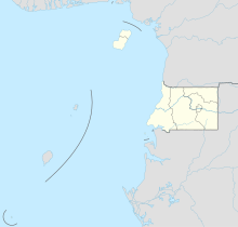
| Map | |||||||||||
| Corisco International Airport | |||||||||||
| Runways | |||||||||||
| |||||||||||
- •
town and civil parish
Welton
Welton-by-Lincoln | |
|---|---|
Town and civil parish | |
 Clockwise from top: Welton town centre; the war memorial in front of St Mary's Church; Welton Beck; village pump; St Mary's Church with cemetery in foreground; Victoria's jubilee lamp; village sign on Lincoln Road | |
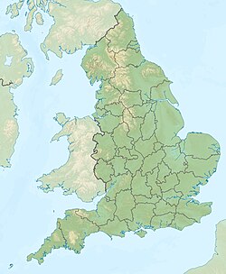
 Welton civil parish within Lincolnshire | |
Location within Lincolnshire Location within England Location within the United Kingdom Location within Europe | |
| Coordinates: 53°18′10″N 0°28′33″W / 53.302878°N 0.475938°W | |
| Country | |
| Country | |
| Region | East Midlands |
| County | |
| District | West Lindsey |
| Constituency | Gainsborough |
| Ward | Welton and Dunholme |
| Civil parish |
|
| Government | |
| • Body | Welton Parish Council |
| • Chairman | Alan Greenway[3] |
| • Vice-Chairman | Marlene Chapman[3] |
| Area | |
| • Total (CP) | 16 km2 (6 sq mi) |
| • Water | 1.2 km2 (0.5 sq mi) |
| • Urban | 3.5 km2 (1.4 sq mi) |
| Population (2011)[4] | |
| • Total (CP) | 4,327 |
| • Density | 270/km2 (700/sq mi) |
| Demonym(s) | Welletonian, Weltoner, Weltonese |
| Time zone | UTC±0 (Greenwich Mean Time) |
| • Summer (DST) | UTC+1 (British Summer Time) |
| Postcode district | |
| Post town | |
| Dialling code | 01673 |
| Police Ambulance | Lincolnshire East Midlands |
| OS grid reference • London | TF015795 202 km (126 mi) S |
| Language | English |
| Website | www |
|
|
| ||||||||||||||||||||||||||||||||||||||||||||||||||||||||||||||||||||||||
| ||||||||||||||||||||||||||||||||||||||||||||||||||||||||||||||||||||||||||
| Source: [7][8][9][10][11] | ||||||||||||||||||||||||||||||||||||||||||||||||||||||||||||||||||||||||||
|
| ||||||||||||||||||||||||||||||||||||||||||||||||||||||||||||||||||
| |||||||||||||||||||||||||||||||||||||||||||||||||||||||||||||||||||
| Source: [7][8][12] | |||||||||||||||||||||||||||||||||||||||||||||||||||||||||||||||||||

The former hamlet of Ryland in the east of Welton
53.3183393, -0.4283606
53.3079371, -0.4698724
| Graphs are unavailable due to technical issues. There is more info on Phabricator and on MediaWiki.org. |
- ^ Airport information for OCS at Great Circle Mapper.
- ^ Google Maps - Corisco
- ^ a b Cite error: The named reference
:142was invoked but never defined (see the help page). - ^ Cite error: The named reference
:pop 2011was invoked but never defined (see the help page). - ^ a b "Settlement - Chapels". www.slha.org.uk. Retrieved 2022-06-06.
- ^ Great Britain Census Office (1862). Census of England and Wales for the Year 1861 ...: Numbers and distribution of the people.
- ^ a b Cite error: The named reference
:722was invoked but never defined (see the help page). - ^ a b Cite error: The named reference
:2001was invoked but never defined (see the help page). - ^ "Welton AP/CP through time | Population Statistics". A Vision of Britain through Time. GB Historical GIS / University of Portsmouth. Retrieved 21 March 2022.
- ^ "Dataset Selection - Query - Nomis - Official Labour Market Statistics". www.nomisweb.co.uk. Retrieved 2022-06-14.
- ^ "Casweb 1971 Select Areas". casweb.mimas.ac.uk. Retrieved 2022-06-14.
- ^ "Welton AP/CP through time | Population Statistics". A Vision of Britain through Time. GB Historical GIS / University of Portsmouth. Retrieved 21 March 2022.


