User:Droll/subpages/sandbox1
| Mount Mansfield | |
|---|---|
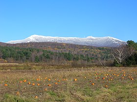
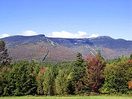 Mount Mansfield, September 2004 | |
| Highest point | |
| Elevation | 4,395.3 ft (1,339.7 m) NAVD 88[1] |
| Prominence | 3,633 ft (1,107 m)[2] |
| Listing | |
| Coordinates | 44°32′38″N 72°48′52″W / 44.543946911°N 72.814309717°W[1] |
| Geography | |
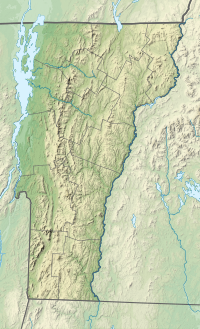
| Location | |
| Parent range | Green Mountains |
| Topo map | USGS Mount Mansfield |
| Climbing | |
| Easiest route | Hike |
| Designated | 1980 |
Mount Mansfield is the highest mountain in Vermont with a summit that peaks at 4,395 feet (1,340 m) above sea level.[3] The summit is located within the town of Underhill in Chittenden County; the ridgeline, including some secondary peaks, extends into the town of Stowe in Lamoille County, and the mountain's flanks also reach into the town of Cambridge.[4]
When viewed from the east or west, this mountain has the appearance of a (quite elongated) human profile, with distinct forehead, nose, lips, chin, and Adam's apple. These features are most distinct when viewed from the east; unlike most human faces, the chin is the highest point.[5]
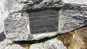
Mount Mansfield is one of three spots in Vermont where true alpine tundra survives from the Ice Ages. A few acres exist on Camel's Hump and Mount Abraham nearby and to the south, but Mount Mansfield's summit still holds about 200 acres (81 ha). In 1980, the Mount Mansfield Natural Area was designated as a National Natural Landmark by the National Park Service.[6]
Located in Mount Mansfield State Forest, the mountain is used for various recreational and commercial purposes. "The Nose" is home to transmitter towers for a number of regional radio and TV stations.[7][8] There are many hiking trails, including the Long Trail, which traverses the main ridgeline. In addition, the east flank of the mountain is used by the Stowe Mountain Resort for winter skiing. A popular tourist activity is to take the 4.5-mile (7.2 km) toll road (a steep, mostly unpaved road with several hairpin turns) from the Stowe Base Lodge to "The Nose" and then hike along the ridge to "The Chin."
Geology and soils
[edit]The dominant bedrock of Mt. Mansfield is a mica-albite-quartz schist common to the Green Mountains, with mica being the most abundant mineral.[9][10] Layers of quartzite are found locally.[11] The soils, mostly podzol, are stony with fine-earth fractions grading through textures of fine sandy loam, loam and silt loam; they are mapped mostly as Londonderry, Lyman, Peru and Tunbridge Series with considerable areas of rock outcropping around the summit.[12]
Etymology
[edit]The name of the mountain comes from the dissolved town of Mansfield, Vermont, in which the mountain was located (its territory was later divided between the towns of Underhill and Stowe), but the source of the town's name is the subject of some dispute.
Several of the original grantees of the land in Mansfield were from Mansfield, Connecticut, which in turn is known to have been named for Moses Mansfield, one of the chief landowners there. However, Benning Wentworth, the governor of the British colony of New Hampshire, issued a charter to a group of grantees in what he dubbed the town of Mansfield, possibly for a chief justice of England, Lord Mansfield (a British judge who deemed slavery illegal on British soil in 1772). Wentworth had good reason to honor Lord Mansfield by naming a town after him: Mansfield and another English official had jointly ruled in 1752 that the land between the Connecticut River and Lake Champlain should be considered part of the Wentworth-governed royal province of New Hampshire, and not of New York, which also claimed that territory.[13]
The Town of Mansfield was formed before anyone involved had visited the site; when the townsite was surveyed, it was discovered to be mostly mountainside.[14] Although a few hardy pioneers settled in the town's few lowlands, the town was dissolved by degrees, with the portion generally west of the mountain being annexed to Underhill in 1839, the eastern portion to Stowe in 1848 after a vote of the citizenry. The dividing line did not run exactly along the ridge of the mountain; thus, the Chin is in Underhill and the Nose in Stowe.[15] Prior to the mid-eighteenth century, the mountain was known by its Abenaki name, Mozodepowadso, which translates to Moosehead Mountain.[16]
Topography
[edit]
The ridge which forms the "head" of the "man" is aligned generally north and south. The "Adam's apple" is on the north end of the ridge, and the "forehead" to the south. From north of the mountain, looking south, this ridge appears as a triangular peak. At the northeastern portion of the mountain, there are cliffs. At the base of these cliffs (on the western side of the Notch Road, Vermont Route 108), there is a honeycomb network of talus caves. There are cliffs on the eastern side of the Notch Road as well. These two sets of facing cliffs are separated by 3 yards (2.7 m) at their base.[citation needed]
Skiing
[edit]Along with other expert trails, a group of trails, known as the "Front Four", are Goat, Starr, National and Liftline. They have steep pitches, many natural hazards (rocks and trees), and little grooming. There are also cross country ski trails around the base of the mountain and on its lower slopes. The Bruce Trail descends the east side of the mountain while the Teardrop Trail descends west side. In addition to Stowe Mountain resort, Skiing is also available at the nearby Smugglers' Notch Resort.
Gallery
[edit]-
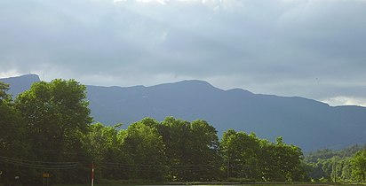
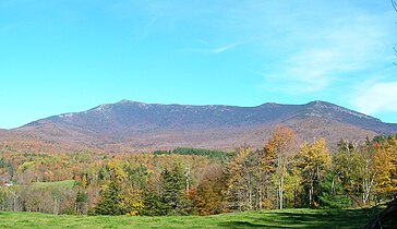
Western Slope of Mt. Mansfield from Underhill, Vermont.
-
Mansfield from north of Stowe, Vermont.
-
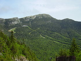
Mansfield from toll road.
-
Looking south towards Camels Hump off the summit ridge.
-
Northerly view of Mt. Mansfield from the summit of Camel's Hump.
-
View from River Rd., Underhill, Vermont.
-
View from Stevensville Rd., Underhill.
-
A plaque along the Long Trail between the "Chin" and the "Nose" of Mount Mansfield.
Climate
[edit]Mount Mansfield is located in a boreal temperate rainforest and receives more than 80 inches of precipitation each year on average and has a humid boreal climate (Dfc). Lower elevations of the mountain have a humid continental climate[17] [18]
Summer days on the mountain are warm coupled with cool nights, while winters are long, cold and snowy, lasting from November through April and with annual snowfall averaging 235 in (6.0 m). The highest daily snowfall recorded was 28 in (71 cm) and occurred on March 15, 2017. The highest snow depth recorded was 149 in (3.8 m) and occurred on April 2 during the very snowy winter of 1969. According to the NOAA, snowfall has been recorded on the summit for every month of the year.[19] Mount Mansfield averages 197.7 nights at or below 32 °F (0 °C) annually. Extreme temperatures ranges from 85 °F (29 °C) on May 28, 2020 to −39 °F (−39 °C) on January 9, 1968.
| Climate data for Mount Mansfield, Vermont, 1991–2020 normals, extremes 1954–present | |||||||||||||
|---|---|---|---|---|---|---|---|---|---|---|---|---|---|
| Month | Jan | Feb | Mar | Apr | May | Jun | Jul | Aug | Sep | Oct | Nov | Dec | Year |
| Record high °F (°C) | 53 (12) |
56 (13) |
65 (18) |
74 (23) |
85 (29) |
84 (29) |
84 (29) |
82 (28) |
79 (26) |
76 (24) |
63 (17) |
60 (16) |
85 (29) |
| Mean maximum °F (°C) | 42.2 (5.7) |
38.7 (3.7) |
46.9 (8.3) |
60.4 (15.8) |
70.9 (21.6) |
75.3 (24.1) |
76.0 (24.4) |
74.2 (23.4) |
71.3 (21.8) |
62.4 (16.9) |
52.6 (11.4) |
43.7 (6.5) |
77.6 (25.3) |
| Mean daily maximum °F (°C) | 21.1 (−6.1) |
22.7 (−5.2) |
30.2 (−1.0) |
42.6 (5.9) |
57.0 (13.9) |
65.3 (18.5) |
69.0 (20.6) |
67.6 (19.8) |
61.1 (16.2) |
47.7 (8.7) |
36.2 (2.3) |
26.6 (−3.0) |
45.6 (7.6) |
| Daily mean °F (°C) | 13.4 (−10.3) |
15.0 (−9.4) |
22.9 (−5.1) |
35.0 (1.7) |
48.9 (9.4) |
57.8 (14.3) |
62.2 (16.8) |
60.9 (16.1) |
54.2 (12.3) |
41.4 (5.2) |
29.8 (−1.2) |
19.8 (−6.8) |
38.4 (3.6) |
| Mean daily minimum °F (°C) | 5.7 (−14.6) |
7.3 (−13.7) |
15.6 (−9.1) |
27.5 (−2.5) |
40.8 (4.9) |
50.3 (10.2) |
55.4 (13.0) |
54.2 (12.3) |
47.3 (8.5) |
35.1 (1.7) |
23.4 (−4.8) |
12.9 (−10.6) |
31.3 (−0.4) |
| Mean minimum °F (°C) | −22.4 (−30.2) |
−18.1 (−27.8) |
−12.1 (−24.5) |
7.0 (−13.9) |
21.6 (−5.8) |
32.8 (0.4) |
41.4 (5.2) |
40.2 (4.6) |
28.9 (−1.7) |
16.7 (−8.5) |
3.3 (−15.9) |
−12.5 (−24.7) |
−25.6 (−32.0) |
| Record low °F (°C) | −39 (−39) |
−36 (−38) |
−31 (−35) |
−13 (−25) |
5 (−15) |
20 (−7) |
26 (−3) |
25 (−4) |
16 (−9) |
5 (−15) |
−11 (−24) |
−38 (−39) |
−39 (−39) |
| Average precipitation inches (mm) | 5.62 (143) |
5.26 (134) |
5.88 (149) |
6.31 (160) |
6.88 (175) |
7.86 (200) |
7.31 (186) |
6.89 (175) |
7.26 (184) |
7.63 (194) |
6.68 (170) |
7.51 (191) |
81.09 (2,061) |
| Average snowfall inches (cm) | 40.9 (104) |
44.6 (113) |
38.7 (98) |
21.4 (54) |
5.5 (14) |
0.0 (0.0) |
0.0 (0.0) |
0.0 (0.0) |
0.1 (0.25) |
10.1 (26) |
30.4 (77) |
43.2 (110) |
234.9 (596.25) |
| Average precipitation days (≥ 0.01 in) | 21.6 | 18.2 | 17.2 | 15.4 | 15.4 | 16.2 | 16.3 | 15.2 | 14.4 | 15.0 | 17.3 | 21.5 | 203.7 |
| Average snowy days (≥ 0.1 in) | 18.2 | 16.1 | 13.0 | 6.4 | 1.8 | 0.0 | 0.0 | 0.0 | 0.2 | 3.8 | 10.4 | 17.0 | 86.9 |
| Source 1: NOAA[20] | |||||||||||||
| Source 2: National Weather Service[21] | |||||||||||||
See also
[edit]References
[edit]- ^ a b "Mt Mansfield Highest Point". NGS Data Sheet. National Geodetic Survey, National Oceanic and Atmospheric Administration, United States Department of Commerce. Retrieved 2008-12-11.
- ^ "Mount Mansfield, Vermont". Peakbagger.com. Retrieved 2008-12-15.
- ^ Conway, Michael J. Vieira & J. North (2017-04-10). New England Rocks: Historic Geological Wonders. Arcadia Publishing. ISBN 978-1-4396-6034-8.
- ^ Vermont Atlas & Gazetteer, Delorme, 1996, p. 46.
- ^ Robert L. Hagerman, Mansfield: The Story of Vermont's Loftiest Mountain. Essex Publishing Co., Essex Junction, Vt., 1971, pp. 23-24.
- ^ "National Natural Landmarks - National Natural Landmarks (U.S. National Park Service)". www.nps.gov. Retrieved 2019-04-12.
Year designated: 1980
- ^ Radio stations in Burlington, VT (see info under Mount Mansfield with photos on bottom of the page), worldradiomap.com
- ^ Engineering Radio/TV Mount Mansfield
- ^ Chistman, Robert A. (1956). "The Geology of Mt. Mansfield State Forest" (PDF). Department of Forest and Parks.
- ^ Stier, Maggie; McAdow, Ron (1995). Into the Mountains: Stories of New England's Most Celebrated Peaks. Appalachian Mountain Club Books. ISBN 978-1-878239-30-3.
- ^ "Welcome to DEC - Department of Environmental Conservation" (PDF). www.anr.state.vt.us.
- ^ "SoilWeb: An Online Soil Survey Browser - California Soil Resource Lab". casoilresource.lawr.ucdavis.edu.
- ^ Robert, Hagerman (1975). Mansfield: The Story of Vermont's Loftiest Mountain.
- ^ Bushnell, Mark (September 15, 2019). "Whence Camel's Hump and other Vermont mountain names?". VTDigger. Retrieved 16 March 2020.
- ^ Hagerman, chap. 4; Chris Hanna, Mansfield: A Town Divided. Accessed 2009.09.21.
- ^ https://www.sevendaysvt.com/vermont/whats-in-a-name-sleuthing-a-mountain-called-mansfield/Content [dead link]
- ^ "Climate Zones". BONAP. Prism Climate Group.
- ^ Why We Find Rainforests in Unexpected Places, retrieved 2023-07-31
- ^ Team, National Weather Service Corporate Image Web. "National Weather Service - Burlington, VT". w2.weather.gov. Retrieved 2020-06-08.
- ^ "U.S. Climate Normals Quick Access". National Oceanic and Atmospheric Administration. Retrieved October 8, 2022.
- ^ "NOAA Online Weather Data". National Weather Service. Retrieved October 8, 2022.
- Johnson, Charles W. (1980). The Nature of Vermont: Introduction and Guide to a New England Environment. The University Press of New England. ISBN 0-87451-183-6.
External links
[edit]- "Mount Mansfield". Geographic Names Information System. United States Geological Survey, United States Department of the Interior. Retrieved 2008-12-15.
- "Mount Mansfield". SummitPost.org. Retrieved 2008-12-15.
- "Mount Mansfield Photo Group". Flickr. December 2008. Retrieved 2008-12-29.
- "Mount Mansfield hike and trip report". Peak Fever. June 2011. Retrieved 2011-07-04.
Category:Mountains of Vermont
Category:New England Four-thousand footers
Category:Regions of Vermont
Category:Landforms of Chittenden County, Vermont
Category:Landforms of Lamoille County, Vermont
Category:Highest points of U.S. states
Category:North American 1000 m summits
Category:National Natural Landmarks in Vermont

