User:Cataclasite/sierramadreoccidentalvolcfielddraft


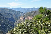
The Sierra Madre Occidental large igneous province (SMO LIP) is a silicic large igneous province (LIP) located in western Mexico. It is composed of relatively undeformed silicic volcanic rocks, and is one of the largest silicic LIPs in the world. It forms a high elevation plateau approximately 200 to 500 km wide by 1200 km long that mostly coincides with the mountainous Sierra Madre Occidental physiographic province, and is incised by deep canyons, including Copper Canyon. It is remarkable for being the largest relatively undeformed silicic LIP in the world, the largest silicic LIP of Cenozoic age, host to numerous epithermal gold deposits, and one of the least-studied large igneous provinces in the world, due in part to the remoteness of area.
Geology and Origin
[edit]The Sierra Madre Occidental large igneous province consists of approximately 400,000 km3 of silicic volcanic rocks erupted primarily between 38 and 28 million years ago. Beneath the SMO LIP are older calc-alkaline intermediate composition igneous rocks and some volcaniclastics derived from weathering and erosion of the igneous rocks; these rocks are referred to as the lower volcanic complex (LVC).
In places, for example near Creel and Divisadero, the SMO LIP contains numerous sheets of ignimbrite up to 300 m in thickness. Each thick sheet of ignimbrite was deposited by a single eruption, which is evidenced by the transition from moderately welded, pumice rich tuff in the upper portion of the sheet to a strongly welded tuff with highly flattened pumice in the lower sections. Thus the SMO LIP was at least in part formed by numerous highly explosive, large, caldera-forming eruptions. The thickness of some of the ignimbrite sheets suggests that some of the eruptions may have been supervolcano-type eruptions, with VEI of 8. However, to date the lateral extents of the ignimbrite sheets have not been fully mapped and few calderas have been discovered in the area. Consequently the volume of ignimbrite formed in each eruption and the locations from which most of the ignimbrites of the SMO LIP erupted are unknown. The rocks of the LVC were formed in a continental arc caused by subduction along the west coast of Mexico. Rocks similar to those of the LVC are typical of continental arcs.
To the south of, and adjacent to the SMO LIP is another large region of volcanic rocks called the Trans-Mexican Volcanic Belt, which contains rocks more mafic than those in the SMO LIP. The rocks of the Trans-Mexican Volcanic Belt are slightly younger than the SMO LIP, and the rocks in the southern part of the SMO LIP, near to the Trans-Mexican Volcanic Belt, are younger than rocks in the northern part of the SMO LIP. Thus, it appears that volcanic activity moved progressively south from the northern part of the SMO LIP into the Trans-Mexican Volcanic Belt over time. The SMO LIP is part of the Mid-Tertiary ignimbrite flare-up in which significant but smaller volumes of ignimbrite were erupted in various locations in western North America about the same time as the SMO LIP.
Significant amounts of precious metals, in particular gold, have been mined from the SMO LIP and LVC, especially in the western portions of the LIP. The Copper Canyons of the Sierra Madre Occidental are cut into the SMO LIP, and the area is home to the Sierra Tarahumara Indians (Rarámuri).
The cause of the prolific volcanic activity that created the SMO LIP is unknown. Possible causes include subduction along the west coast of Mexico and activity in the mantle related to rifting of Baja California away from the coast of Mexico.
See Also
[edit]- Mid-Tertiary ignimbrite flare-up
- large igneous province
- Trans-Mexican Volcanic Belt
- Geology of Mexico
- Supervolcano
- Volcanic Explosivity Index
References
[edit]Busby, C., 2008, Geology of the Sierra Madre Occidental, Mexico, http://www.largeigneousprovinces.org/08nov.html
McDowell, F.W., 2007, Geologic transect across the northern Sierra Madre Occidental volcanic field, Chihuahhua and Sonora, Mexico: Geological Society of America Digital Map and Chart Series 6, 70 pp.
Robertson, S.A., J.K. Schoenrock, D.C. Witt, M.P. Bunds, S.H. Emerman, and J. Bradford, Volcanostratigraphy of the Divisadero Tuff in Rio San Ignacio Canyon, Creel, Mexico, 62nd Annual Meeting, Geological Society of America, Rocky Mountain Section, Rapid City, South Dakota, April 22, 2010.
Schoenrock, J., S.A. Robertson, D.C. Witt, M.P. Bunds, S.H. Emerman, and J. Bradford, Volcanostratigraphic and hydrogeologic study to site a well in Basigorabo, Sierra Tarahumara, Mexico, 62nd Annual Meeting, Geological Society of America, Rocky Mountain Section, Rapid City, South Dakota, April 23, 2010.
Swanson E., 2003, Volcanic stratigraphy of the Creel-Divisadero area, Chihuahua, Mexico. Abstracts with Programs - Geological Society of America [serial online]. April 1, 2003;35(4):19.
Swanson, E.R. and McDowell, F.W., 1984, Calderas of the Sierra Madre Occidental volcanic field, western Mexico: Journal of Geohysical Research, v. 89, p.8787-8799.
Swanson E.R., Kempter. K.A., McDowell, F.W., and McIntosh, W.C., 2006, Major ignimbrites and volcanic centers of the Copper Canyon area: A view into the core of Mexico’s Sierra Madre Occidental: Geosphere,v. 2, no. 3, p. 125-141.
Witt, D.C., M.P. Bunds, J.K. Schoenrock, S.A. Robertson, S.H. Emerman, and J. Bradford, Volcanostratigraphy of the Divisadero Tuff in the Sierra Tarahumara near Escuela San Elias, Chihuahua, Mexico, 62nd Annual Meeting, Geological Society of America, Rocky Mountain Section, Rapid City, South Dakota, April 23, 2010.
External links
[edit]27°36′N 108°00′W / 27.6°N 108°W
Category:Plate tectonics Category:Large igneous provinces Category:Tertiary volcanism
