User:Bangiomorpha/draft charleroi
add new chapters to the EN page based on a translation of the French page :
Geography
[edit]Topography and hydrography
[edit]
Charleroi's topography is influenced by the valley of the river Sambre, which flows from west to east before joining the Meuse at Namur. The Piéton stream flows from north to south to join the Sambre at Dampremy. The Charleroi-Brussels canal is dug in the valley of this stream. The Eau d'Heure comes from the south and also flows into the Sambre at Marchienne-au-Pont. About twenty streams run through the territory of the municipality.[1]
The altitude ranges from 100 metres (Sambre and Piéton valleys) to over 220 metres at the Bois du Prince in Marcinelle. The level is 132 metres on the Place Charles II. The height of the slag heaps often exceeds 200 metres, the Saint-Charles slag heap in the Bois du Cazier reaches 241 metres.[2]
Biodiversity
[edit]The six slag heaps in the Pays Noir are reservoirs of biodiversity that should be preserved.[3]
Like the calcareous grassland, the slag heaps are habitats created by human activity that are home to many very specific and often threatened animal and plant species. The rarity of these species depends on the rarity of the environment itself (the biotope). Contrary to popular belief, the forest is not the only place with biodiversity! Biodiversity is also present in other environments: in a wasteland, a body of water, a meadow, etc. In terms of biodiversity, it is therefore preferable to maintain a mosaic of habitats, hence the interest in preserving different types of environments on the slag heaps.[4]
The Viviers site, for example, is an old mining site located in the east of Charleroi (Gilly). This site has a small conical slag heap and large open areas consisting mainly of pioneer grassland and wasteland. It also includes a small body of water as well as temporary ponds, and some wooded areas on the western and northern edges. This particular biotope is of great biological interest and acts as a refuge for a diverse fauna. The vast reed bed surrounding the pond is home to the red warbler, a passerine bird specific to this type of vegetation. Several species of amphibians can be seen here, including a population of the natterjack toad, as well as certain insects, such as the magnificent blue-winged grasshopper.[5]
The Martinet site, a former colliery on the boundary of the Monceau-sur-Sambre and Roux sections, is in the process of being rehabilitated and reallocated. Like the Viviers slag heap in Gilly, this vast site is of great biological interest.[6]
History
[edit]Late modern
[edit]1830...
1868
WWII
In July 1942, during the nazi occupation of belgium, Greater Charleroi was created, a giant operation involving 31 municipalities and assimilating 340,000 inhabitants. This agglomeration allowed for the application of the Führerprinzip. Greater Charleroi was controlled by the Rexist majority and Mayor Jean Teughels until September 1944.
http://ndl.ethernet.edu.et/bitstream/123456789/70449/1/55.pdf.pdf
1977 Fusion of the Belgian municipalities
- closing of mine sites
- closing of steelworks and glass industries
29th of september 1984 – the last coal mine closes the doors in Farcienne, Charleroi
https://ec.europa.eu/energy/sites/ener/files/documents/4.2._coal_mine_closure_companies.pdf
Euro 2000
https://www.theguardian.com/football/2000/may/24/euro2000.sport
In the early 2000s, Charleroi is known by the local and national community for "les Affaires" ('the misdeeds'). A system of institutionalized corruption where the city's political class was involved leading to labeling the city the "Chicago of Belgium". With the advent of the new Crown Prosecutor Christian De Valkeneer in 2005, there was a shift in priorities from his predecessor and this produced more than 50 dossiers. Among them were the Carolorégienne housing scandal, illicit subsidies to local sports clubs, the Wagner industrialist affair, and garbage burying.[7]
- 2016 closing of Caterpiller
https://www.vrt.be/vrtnws/en/2016/09/02/over_2_000_jobs_tobeaxedatcaterpillaringosselies-1-2757921/https://www.euronews.com/2016/09/02/2000-jobs-under-threat-at-caterpillar-in-belgium
Marcinelle’s ‘house of horror’, the former home of Belgium’s most notorious paedophile Marc Dutroux, is undergoing demolition...
https://www.thebulletin.be/demolition-work-starts-marc-dutrouxs-house-marcinelle
20th century
[edit]Contemporary
[edit]Up to this point, Charleroi's reputation has suffered a decay defined by a series of different crises concatenated over the previous decades : economic, political and social. To enshrine its image, in 2008, readers of a Dutch newspaper, De Volksrant, called it "the ugliest city in the world."[8]
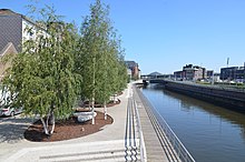
Starting in the first decade of the 2000s, the city began to adopt a series of urban renewal policies in order to increase its atractivity. The first is the Phènix plan (2007-2013) that brought multiple architectural and urban renewal projects such as the pedestrian redevelopment of quai Rimbaud. In 2012, the metro loop completed the segment between Charleroi-South and Parc stations is inaugurated.[9] This impulsion led to the construction in 2017 of the Rive Gauche shopping mall, which in turn led to the renovation of the Place Verte.
In 2014, the city council adopted the figure of the Bouwmeester to define .... . A typical figure for Flanders and the Brussels capital region, but new to Wallonia.
The EDRF wallon program 2014-2020 "Creative District"....
External website :
[edit]https://www.charleroi-metropole.be/en/boroughs/charleroi/
- ^ "Carte d'identité du sous-bassin hydrographique de la Sambre" (PDF). Contrat de Rivière Sambre & Affluents (in French). Retrieved 2022-07-29.
- ^ Topografische atlas België = Atlas topographique Belgique : 1:50.000. Marcel, Fietsgidsen Gevaert, Nationaal Geografisch Instituut. [Brussel]: Touring. 2002. p. 206-207. ISBN 90-209-4853-9. OCLC 66924806.
{{cite book}}: CS1 maint: others (link) - ^ "Biodiversity 2020, Update of Belgium's National Strategy | Convention on Biological Diversity". www.biodiv.be. Retrieved 2022-07-29.
- ^ Danna-Allegrini, Brunella; Henry, Marion (2020-01-01). "Charleroi: Slag Heaps and New Landscape" (PDF). inForma. 12: 32–38. ISSN 2637-7950.
- ^ "2638 - Terril des Viviers | Rechercher un site intéressant ou protégé | Sites | La biodiversité en Wallonie". biodiversite.wallonie.be. Retrieved 2022-07-29.
- ^ "Terril du Martinet (FR)". Destination Terrils. Retrieved 2022-07-29.
- ^ Philip, Peter (2007-11-25). "How did they get away with it ?". The Bulletin. pp. 12–13.
- ^ Times, The Brussels. "An urban safari in the ugliest city in the world". www.brusselstimes.com. Retrieved 2022-08-01.
- ^ "Phénix (Charleroi) | WalEurope". europe.wallonie.be. Retrieved 2022-08-01.
