User:Awickert/Sandbox/Methods of geology
TO DO:
- Outline
- Connect to popular conceptions of geology
- Good images/photographs to illustrate key details
- Showing field methods
- Showing lab methods
- Showing a geologic map and cross-section
- Write!
TO others: Please add on to the to-do list, edit this work, tell me if you think this is totally the wrong approach (b/c I'm having trouble making it encyclopedic instead of sort-of a story and making it jargon-free), etc. Awickert (talk) 19:38, 25 January 2009 (UTC)
Methods of Geology
[edit]The field is the primary source from which geologists gain information on processes that have occurred throughout the history of the Earth. First investigations into the field are carried out by creating a geologic map of the area.
In creating this map, geologists first describe and map the locations of different geologic units. While doing so, they:
- Describe each rock unit so they can identify it in other outcrops in the field area. This description can include:
- Whether the rock is igneous, metamorphic, or sedimentary
- Mineralogical characteristics
- ...
From this description, the geologists give the rock a name, such as "Brown sandy limestone" or "Green pyrite schist"...
- Strat column
- Structure
In order to create this map, geologists first create a stratigraphic column, which
Methods of Geology
[edit]Geologists use a number of field, laboratory, and numerical modeling methods to decipher Earth history and understand the processes that occur on and in the Earth. In typical geological investigations, geologists use primary information related to petrology (the study of rocks), stratigraphy (the study of sedimentary layers), and structural geology (the study of positions of rock units and their deformation). In many cases, geologists also study modern soils, rivers, landscapes, and glaciers; investigate past and current life and biogeochemical pathways, and use geophysical methods to investigate the subsurface.
Fieldwork
[edit]

Geological field work varies depending on the task at hand. Typical fieldwork could consist of:
- Geological mapping
- Structural mapping: the locations of the major rock units and the faults and folds that led to their placement there.
- Stratigraphic mapping: the locations of sedimentary facies (lithofacies and biofacies) or the mapping of isopachs of equal thickness of sedimentary rock
- Surficial mapping: the locations of soils and surficial deposits
- Surveying of topographic features
- Creation of topographic maps
- Work to understand change across landscapes, including:
- Patterns of erosion and deposition
- River channel change through migration and avulsion
- Hillslope processes
- Subsurface mapping through geophysical methods.
- These methods include:
- Shallow seismic surveys
- Ground-penetrating radar
- Electrical resistivity tomography
- They are used for:
- These methods include:
- High-resolution stratigraphy
- Measuring and describing stratigraphic sections on the surface
- Well drilling and logging
- Biogeochemistry and geomicrobiology
- Collecting samples to:
- Determine biochemical pathways
- Identify new species of organisms. These organisms may help to show:
- Identify new chemical compounds
- And to use these discoveries to
- Understand early life on Earth and how it functioned and metabolized
- Find important compounds for use in pharmaceuticals.
- Collecting samples to:
- Paleontology: excavation of fossil material
- Collection of samples for geochronology and thermochronology
- Glaciology: measurement of characteristics of glaciers and their motion
Laboratory Work
[edit]
Petrology
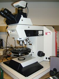
[edit]In addition to the field identification of rocks, petrologists identify rock samples in the laboratory. Two of the primary methods for identifying rocks in the laboratory are through optical microscopy and by using an electron microprobe. In an optical mineralogy analysis, thin sections of rock samples are analyzed through a petrographic microscope, where the minerals can be identified through their different properties in plane-polarized and cross-polarized light, including their birefringence, pleochroism, twinning, and interference properties with a conoscopic lens. In the electron microprobe, individual locations are analyzed for their exact compositions.
Petrologists also perform experiments to understand the temperatures and pressures at which different mineral phases appear, and how they change through igneous and metamorphic processes. This research can be extrapolated to the field to understand metamorphic processes and the conditions of crystallization of igneous rocks. This work can also help to explain processes that occur within the Earth, such as subduction and magma chamber evolution.
Structural Geology
[edit]
Structural geologists use microscopic analysis of oriented thin sections of geologic samples to observe the fabric within the rocks which gives information about strain within the crystal structure of the rocks. They also perform analog and numerical experiments of rock deformation in large and small settings.
Among the most well-known experiments in structural geology are those involving orogenic wedges, which are zones in which mountains are built along convergent tectonic plate boundaries. In the analog versions of these experiments, horizontal layers of sand are pulled along a lower surface into a back stop, which results in realistic-looking patterns of faulting and the growth of an critically-tapered (all angles remain the same) orogenic wedge. Numerical models work in the same way as these analog models, though they are often more sophisticated and can include patterns of erosion and uplift in the mountain belt. This helps to show the relationship between erosion and the shape of the mountain range. These studies can also give useful information about pathways for metamorphism through pressure, temperature, space, and time.
Stratigraphy
[edit]In the laboratory, stratigraphers analyze samples of stratigraphic sections that can be returned from the field, such as those from drill cores. Stratigraphers also analayze data from geophysical surveys that show the locations of stratigraphic units in the subsurface. Geophysical data and well logs can be combined to produce a better view of the subsurface, and stratigraphers often use computer programs to do this in three dimensions. Stratigraphers can then use these data to interpret past environments and locate areas for water and hydrocarbon extraction.
Methods of Geology
[edit]The study of rocks (petrography, petrology, mineralogy)
[edit]Types of Rocks
[edit]I'm going to write all I can think we'd want on this here, and we can split it into methods and modern later; I'm not sure how much I like the "modern" category, since I formed it as a counterpoint to the current info on the article. Awickert (talk) 07:07, 26 January 2009 (UTC)
- My proposal was to split the content in two parts: "methods of geology" and "theories in geology". The rock cycle is a theory, that's why I proposed to have it in the second part of the article. The methods-part explains how geologists work. The theory-section explains what they have discovered, how the Earth functions as a "system", it tells about rock cycle, plate tectonics, age of the Earth, Earth history, etc. Of course there should be a third part on "applied geology", another on "history of geology". Woodwalker (talk) 09:20, 26 January 2009 (UTC)
- rock types (explaining about the three rock types and perhaps a few subdivisions, something about rock textures, something about the rock-forming minerals, ores). Theory on rock formation can be included in the "Modern geology" section (Bowen's series, the rock cycle and all processes it includes). It is a theory, not a method.

Laboratory Analysis
[edit]- thin sections, basic explanation of optical mineralogy, perhaps discuss a few lab methods as well (SEM, spectrometry, EMP?)
the study of rock strata (stratigraphy, sedimentology)
[edit]Rocks that are deposited by wind, water, and/or volcanic events, display a layered structure. Each newer layer is deposited atop the layer that is older. Relationships between these layers are given by a set of principles known as Steno's laws.
- rock strata (only in sedimentary or volcanic rocks), Steno's laws, top-bottom criteria, unconformities, stratigraphic hiatuses
The principle of original horizontality states that sediments are deposited in horizontal to sub-horizontal beds. Observation of modern marine and non-marine sediments in a wide variety of environments supports this generalization. Although cross-bedding is inclined, the overall orientation of cross-bedded units is horizontal.
The principle of superposition states that a sedimentary rock layer in a tectonically undisturbed sequence is younger than the one beneath it and older than the one above it. Logically a younger layer cannot slip beneath a layer previously deposited. This principle allows sedimentary layers to be viewed as a form of vertical time line, a partial or complete record of the time elapsed from deposition of the lowest layer to deposition of the highest bed
The principle of uniformitarianism states that the geologic processes observed in operation that modify the Earth's crust at present have worked in much the same way over geologic time. A fundamental principle of geology advanced by the 18th century Scottish physician and geologist James Hutton, is that "the present is the key to the past." In Hutton's words: "the past history of our globe must be explained by what can be seen to be happening now."
- relative dating techniques (index fossils, magnetic polarities, and others), absolute dating techniques (actually, maybe put absolute separately, b/c intrusions dated as well; or maybe put all of these principles in a geologic time setting, or just have geologic time later)
The principle of faunal succession is based on the appearance of fossils in sedimentary rocks. As organisms exist at the same time period throughout the world, their presence or (sometimes) absence may be used to provide a relative age of the formations in which they are found. Based on principles laid out by William Smith almost a hundred years before the publication of Charles Darwin's theory of evolution, the principles of succession were developed independently of evolutionary thought. The principle becomes quite complex, however, given the uncertainties of fossilization, the localization of fossil types due to lateral changes in habitat (facies change in sedimentary strata), and that not all fossils may be found globally at the same time.
- concept of sedimentary facies, lithostratigraphy
- the study of basin fill and basin development (wedging of sedimentary strata, onlap, toplap, influence of the relative sea level on that, etc)
Structural geology
[edit]- folds, faults, the concept of outcrops and how geologists map them
- intrusions and cross-cutting relationships (igneous rocks in relation to others)
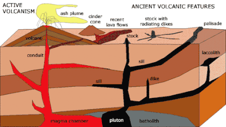
The principle of intrusive relationships concerns crosscutting intrusions. In geology, when an igneous intrusion cuts across a formation of sedimentary rock, it can be determined that the igneous intrusion is younger than the sedimentary rock. There are a number of different types of intrusions, including stocks, laccoliths, batholiths, sills and dikes.
The principle of cross-cutting relationships pertains to the formation of faults and the age of the sequences through which they cut. Faults are younger than the rocks they cut; accordingly, if a fault is found that penetrates some formations but not those on top of it, then the formations that were cut are older than the fault, and the ones that are not cut must be younger than the fault. Finding the key bed in these situations may help determine whether the fault is a normal fault or a thrust fault.
The principle of inclusions and components states that, with sedimentary rocks, if inclusions (or clasts) are found in a formation, then the inclusions must be older than the formation that contains them. For example, in sedimentary rocks, it is common for gravel from an older formation to be ripped up and included in a newer layer. A similar situation with igneous rocks occurs when xenoliths are found. These foreign bodies are picked up as magma or lava flows, and are incorporated, later to cool in the matrix. As a result, xenoliths are older than the rock which contains them.
- stereographic methods in geology
[also used in crystallography/mineralogy]
4) the study of tectonic phases (structural geology, petrology)
[edit]- concept of metamorphic and tectonic phases
- tectonic rocks and their structures and textures
- concept of metamorphic facies, index minerals and metamorphic gradients
- relative and absolute dating of (micro-)structures and minerals in metamorphic rocks
Geological evolution of an area
[edit]
The geology of an area evolves through time as rock units are deposited and inserted and deformational processes change their shapes and locations.
Rock units are first emplaced either by deposition onto the surface or intrusion into the overlying rocks. Deposition can occur when sediments settle onto the surface of the Earth and later lithify into sedimentary rock, or when as volcanic material such as volcanic ash or lava flows, blanket the surface. Igneous intrusions such as batholiths, laccoliths, dikes, and sills, push upwards into the overlying rock, and crystallize as they intrude.

After the initial sequence of rocks has been deposited, the rock units can be deformed and/or metamorphosed. Deformation typically occurs as a result of compression, extension, or side-to-side (strike-slip) motion. These structural regimes broadly relate to convergent boundaries, divergent boundaries, and transform boundaries, respectively, between tectonic plates.

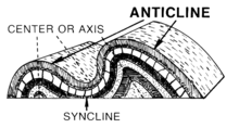
Compression causes the rock units to shorten and become thicker. Because rock units, other than muds, do not significantly change in volume, this is accomplished in two primary ways: through faulting and folding. In the shallow crust, where brittle deformation can occur, thrust faults form, which cause deeper rock to move on top of shallower rock. Because deeper rock is often younger, as noted by the principle of superposition, this can result in older rocks moving on top of younger ones. Deeper in the Earth, the rocks behave plasticly, and buckle and fold instead of faulting. These folds can either be those where the material in the center of the fold buckles upwards, creating "antiforms", or where it buckles downwards, creating "synforms". If the tops of the rock units within the folds remain pointing upwards, they are called anticlines and synclines, respectively. If some of the units in the fold are facing downward, the structure is called an overturned anticline or syncline, and if all of the rock units are overturned or the correct up-direction is unknown, they are simply called antiforms.
Even higher pressures and temperatures during compression can cause both folding and metamorphism of the rocks. This metamorphism causes changes in the mineral composition of the rocks; creates a foliation, or planar surface, that is related to mineral growth under stress; and can remove signs of the original textures of the rocks, such as bedding in sedimentary rocks, flow features of lavas, and crystal patterns in crystalline rocks.
Extension causes the rock units as a whole to become longer and thinner. This is primarily accomplished through normal faulting and through the ductile stretching and thinning. Normal faults drop rock units that are higher below those that are lower. This typically results in younger units being placed below older units. Stretching of units can result in their thinning; in fact, there is a location within the Maria Fold and Thrust Belt in which the entire sedimentary sequence of the Grand Canyon can be seen over a length of less than a meter. Rocks at the depth to be plasticly stretched are often also metamorphosed. These stretched rocks can also pinch into lenses, known as boudins, after the French word for "sausage", because of their visual similarity.
Where rock units slide past one another, strike-slip faults develop in shallow regions, and become shear zones at deeper depths where the rocks deform ductily.

The addition of new rock units, both depositionally and intrusively, often occurs during deformation. Faulting and other deformational processes result in the creation of topographic gradients, causing material on the rock unit that is increasing in elevation to be eroded by hillslopes and channels. These sediments are deposited on the rock unit that is going down. Continual motion along the fault maintains the topographic gradient in spite of the movement of sediment, and continues to create accommodation space for the material to deposit. Deformational events are often also associated with volcanism and igneous activity. Volcanic ashes and lavas accumulate on the surface, and igneous intrusions enter from below. Dikes, long, planar igneous intrusions, enter along cracks, and therefore often form in large numbers in areas that are being actively deformed. This can result in the emplacement of dike swarms, such as those that are observable across the Canadian shield, or rings of dikes around the lava tube of a volcano.
All of these processes do not necessarily occur in a single environment, and do not necessarily occur in a single order. The Hawaiian Islands, for example, consist almost entirely of layered basaltic lava flows. The sedimentary sequences of the mid-continental United States and and the Grand Canyon in the southwestern United States contain almost-undeformed stacks of sedimentary rocks that have remained in place since Cambrian time. Other areas are much more geologically complex. In the southwestern United States, sedimentary, volcanic, and intrusive rocks have been metamorphosed, faulted, foliated, and folded. Even older rocks, such as the Acasta gneiss of the Slave craton in northwestern Canada, the oldest known rock in the world have been metamorphosed to the point where their origin is undiscernable without laboratory analysis. In addition, these processes can occur in stages. In many places, the Grand Canyon in the southwestern United States being a very visible example, the lower rock units were metamorphosed and deformed, and then deformation ended and the upper, undeformed units were deposited. Although any amount of rock emplacement and rock deformation can occur, and they can occur any number of times, these concepts provide a guide to understanding the geological history of an area.
