User:AnnaZenti/Archaeological area of Corte Sgarzerie
Appearance
 | |
 | |
| Location | |
|---|---|
| Coordinates | 45°26′36.64″N 10°59′44.98″E / 45.4435111°N 10.9958278°E |
| History | |
| Cultures | Roman |
| Site notes | |
| Discovered | 1988 |
| Excavation dates | 1988-2004 |
| Management | Superintendence of archaeology, fine arts and lanscape for the provinces of Verona, Rovigo and Vicenza |
| Public access | yes |
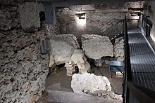
45°26′36.64″N 10°59′44.98″E / 45.4435111°N 10.9958278°E The archaeological area of Corte Sgarzerie is located in the square by the same name in Verona, under the ground level. It comprehends the remains of the Capitolium, the main temple of Roman Verona, dedicated to Jupiter, Minerva and Juno.
The archaeological excavation was carried on between 1988 and 2004 under the medieval loggia situated under the square, bringing to light a section of the cryptoporticus that surrounded the temple on three sides, the remains of an ice-house, and underground space and the foundation of a medieval tower-house.[1]
The archaeological area of Corte Sgarzerie constitutes the only access point to the Capitolium open to the public.
Notes
[edit]- ^ "Area Archeologica di Corte Sgarzerie". archeonaute.it. Archived from the original on June 10, 2021. Retrieved March 2, 2022.
