Uruçuí
Appearance
Uruçuí | |
|---|---|
Municipality | |
| Nickname(s): "Capital dos Cerrados" / "Cidade Futuro" (Capital of Cerrados / Future City) | |
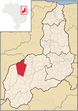
 Location of Uruçuí in Piauí and Brazil | |
| Coordinates: 07°13′44″N 44°33′21″E / 7.22889°N 44.55583°E | |
| Country | |
| Region | Nordeste |
| State | Piauí |
| Mesoregion | Sudoeste Piauiense |
| Founded | September 6, 1902 |
| Government | |
| • Mayor | Valdir Soares da Costa (PT) |
| Elevation | 548 ft (167 m) |
| Population (2020 [1]) | |
| • Total | 21,655 |
| Time zone | UTC−3 (BRT) |
| HDI (2000) | 0.701 – medium[2] |
Uruçuí is a municipality in the state of Piauí in the Northeast region of Brazil.[4] It is the largest municipality in that state by area.
See also
[edit]References
[edit]- ^ IBGE 2020
- ^ [1] - UNDP
- ^ IBGE link to check areas of every municipality in Brazil - IBGE
- ^ "Produto Interno Bruto dos Municípios 2002-2005" (PDF) (in Portuguese). Instituto Brasileiro de Geografia e Estatística (IBGE). December 19, 2007. Retrieved December 17, 2009.

