Upper North Philadelphia
Upper North Philadelphia | |
|---|---|
 Lillian Marrero Branch of the Philadelphia Free Library is located in Upper North Philadelphia's West Kensington | |
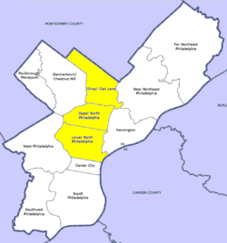
 Map of Philadelphia County with North Philadelphia highlighted. Click for larger image | |
| Country | |
| State | |
| County | |
| City | |
| Area | |
• Total | 44.4 sq mi (115 km2) |
| Population (2010) | |
• Total | 181,531 |
| • Density | 12,241/sq mi (4,726/km2) |
| ZIP code | 19122, 19132, 19133, 19134, 19140 |
Upper North Philadelphia is a section of Philadelphia that is immediately north of Lower North Philadelphia, and can be described as an area that has a "...large and rapidly growing Puerto Rican population".[1]
According to the planning commission, Upper North Philadelphia officially consists of the Allegheny West, Fairhill, Franklinville, Glenwood, Hunting Park, and Nicetown-Tioga neighborhoods. Bounded by York Street to the south, Front Street to the east, Roosevelt Expressway to the north, and Ridge Avenue to the west.
Demographics
[edit]The demographics of Upper North Philadelphia shows that the area has a population density of 12,241 people per mile with an average household size of 3 and 37% of households had children. There is a 17% annual residential turnover rate with 47% of residents staying for more than 5 years, with an average of 6 years of residency. The majority of residents are African Americans and Puerto Ricans.[2]
- Non-Hispanic Black: 106,559 (58.7%)
- Hispanic or Latino of any race: 62,083 (34.2%)
- Mixed or Other: 4,901 (2.7%)
- Non-Hispanic White: 3,994 (2.2%)
- Asian: 3,990 (2.2%)
References
[edit]- ^ Guian A. McKee (15 June 2010). The Problem of Jobs: Liberalism, Race, and Deindustrialization in Philadelphia. ISBN 9780226560144.
- ^ "Upper North Philadelphia, Philadelphia, PA Real Estate Demographics".
- ^ "Factfinder at census.gov". Archived from the original on 2020-02-12. Retrieved 2013-08-24.
- ^ "2010 Census". Medgar Evers College. Archived from the original on 2010-06-11. Retrieved 2010-04-13.
