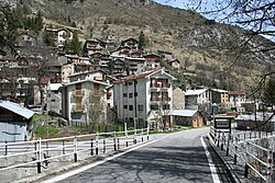
Upega
Appearance
Upega
Üpega (Brigasc dialect) | |
|---|---|
 | |
| Coordinates: 44°07′44″N 7°43′38″E / 44.12889°N 7.72722°E | |
| Country | Italy |
| Region | Piedmont |
| Province | Cuneo |
| Elevation | 1,291 m (4,236 ft) |
| Time zone | UTC+1 (CET) |
| • Summer (DST) | UTC+2 (CEST) |
| Postal code | 12078 |
| Patron saint | Saint Anne |
| Saint day | 26 July |
Upega (Brigasc dialect: Üpega) is a frazione—similar to a hamlet—located in the comune (municipality) of Briga Alta, Province of Cuneo in the region of Piedmont, Italy. It is one of three frazioni that form Briga Alta, alongside Carnino and Piaggia.[1][2] Located in the Upper Tanaro Valley of the Passo Tanarello mountain pass in the Ligurian Alps, the Negrone, which forms the Tanaro river, flows through Upega.[3] Located in the Terra Brigasca culture, it is one of a handful of villages where the Brigasc dialect of the Ligurian language is spoken.[4]
References
[edit]- ^ "Upega". Alta Via del Sale. Retrieved 6 September 2022.
- ^ "Territorio e storia" [Territory and history] (in Italian). Briga Alta. Retrieved 6 September 2022.
- ^ "Linguria" (Map). Carta Regionale. 1:25,000 (in Italian). Cartografia. Archived from the original on 29 May 2017. Retrieved 6 September 2022.
- ^ "Upega" (in Italian). Briga Alta. Retrieved 6 September 2022.


