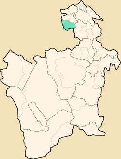
Uncía Municipality
Appearance
Uncía Municipality | |
|---|---|
Municipality | |
 Landscape near Uncía | |
 Location within Potosí Department | |
| Coordinates: 18°36′S 66°26′W / 18.600°S 66.433°W | |
| Country | |
| Department | Potosí Department |
| Province | Rafael Bustillo Province |
| Seat | Uncía |
| Population (2001) | |
| • Total | 18,522 (without Chuquihuta Canton) |
| • Ethnicities | Quechua Aymara |
| Time zone | UTC-4 (BOT) |
]].Indigenous peoples of the Americas|indigenous]] citizens of Quechua and Aymara descent.[1]
| Ethnic group | % |
|---|---|
| Quechua | 69.1 |
| Aymara | 20.0 |
| Guaraní, Chiquitos, Moxos | 0.0 |
| Not indigenous | 10.9 |
| Other indigenous groups | 0.0 |
See also
[edit]References
[edit]- ^ obd.descentralizacion.gov.bo/municipal/fichas/ (inactive)


