Unalaska Island
Native name: Nawan-Alaxsxa[1] | |
|---|---|
 Map of the island | |
| Geography | |
| Location | Aleutian island archipelago, United States and Russia |
| Coordinates | 53°40′24″N 166°38′54″W / 53.67333°N 166.64833°W |
| Archipelago | Fox Islands |
| Major islands | Unalaska |
| Area | 1,051 sq mi (2,720 km2) |
| Length | 128 km (79.5 mi) |
| Width | 56 km (34.8 mi) |
| Highest elevation | 6,680 ft (2036 m) |
| Highest point | Mount Makushin |
| Administration | |
United States | |
| State | Alaska |
| Census Area | Aleutians West Census Area |
| Largest settlement | Unalaska, Alaska (pop. 4432) |
| Demographics | |
| Population | 5,638 (2019) |
| Pop. density | 1.83/km2 (4.74/sq mi) |
| Ethnic groups | Aleut and other Native Alaskan groups |
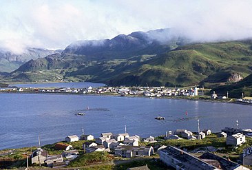
Unalaska (Aleut: Nawan-Alaxsxa,[1] Russian: Уналашка) is a volcanic island in the Fox Islands group of the Aleutian Islands in the US state of Alaska located at 53°38′N 167°00′W / 53.633°N 167.000°W. The island has a land area of 1,051 square miles (2,720 km2). It measures 79.4 mi (127.8 km) long and 34.7 mi (55.8 km) wide. The city of Unalaska, Alaska, covers part of the island and all of neighboring Amaknak Island where the Port of Dutch Harbor is located. The population of the island excluding Amaknak as of the 2000 census was 1,759 residents.
Unalaska is the second-largest island in the Fox Islands group and the Aleutian Islands. The coastline of Unalaska is markedly different in appearance than other major Aleutian Islands, with numerous inlets and peninsulas. The irregular coastline is broken by three long deep bays, Beaver Inlet, Unalaska Bay, and Makushin Bay, as well as by numerous smaller bays and coves. Unalaska's terrain is rugged and covered with mountains, and during the greater part of the year, the higher elevations are covered with snow.[2] The highest point on Unalaska is the active volcano Mount Makushin.
Unalaska is the Aleut name for the island. Several theories about its origin exist; the most likely is that the name derives from the Russian word Ounalashka, an adaptation of the Aleut word for near the mainland, nawan Alaskax.
History
[edit]Native Unalaskans, called Unangan or Aleuts, to non-Unangan, have lived on the island for at least 10,000 years.[3] The island was first seen by westerners in 1741 by Vitus Bering.[4] By 1759, at least 3,000 Aleuts lived on Unalaska island. A Russian settlement was constructed in 1759, but four years later it was destroyed by the Aleuts, together with four merchant ships. The attacks claimed the lives of 162 Russian settlers. The survivors managed to hold their own until 1764, when they were rescued by the Russians. This event triggered bloody reprisals against the natives which took the lives of about 5,000 Aleuts. By 1787, many Aleut seal hunters were enslaved by the Russian American Company and forced to harvest seal fur. By 1840, only 200 to 400 Aleuts still lived on the island.[5]
In October 1778, English explorer James Cook visited the island for three weeks on his third voyage, and spelled it Oonalashka in his journal.[6]
The 1788 expedition of Esteban José Martínez and Gonzalo López de Haro explored the coast of Alaska as far as Unalaska Island, marking the farthest west the Spanish ever explored in the region.[7]
The Russian ship Rurik led by Otto von Kotzebue visited Unalaska twice, in 1815 and 1816. During the second visit, the French-German naturalist Adelbert von Chamisso collaborated with natives to create three-dimensional models of different whale species, in order to transfer and conserve indigenous knowledge about whales. He published drawings along with Aleut species names of the painted driftwood models,[8] which are preserved in Berlin.[9][10][11]
In Moscow on May 31, 1988, President Ronald Reagan mentioned the meeting of Americans and Russians on this island in the 19th century as an example of early US-Russian friendship.
On December 8, 2004, the Malaysian cargo ship Selendang Ayu ran aground off Unalaska Island, causing a large oil spill.
On October 25, 1977, an extremely intense extratropical system struck the area. A pressure of 926 millibars was recorded at Dutch Harbor, which is the lowest non-tropical pressure ever recorded in the United States until December 31, 2020 when another system struck the islands with a pressure of 924.8 millibars.[12]
-
The City of Unalaska, Alaska
-
Unalaska Island in 1972
-
Selendang Ayu ran aground off Unalaska in 2004, spilling approximately 350,000 gallons of oil
References
[edit]- ^ a b Bergsland, K. (1994). Aleut Dictionary. Fairbanks: Alaska Native Language Center.
- ^ US Coast Pilot 9, Chapter 7, Aleutian Islands
- ^ "Unalaska".
- ^ "Unalaska: The US Island Once Ruled by Russia". 26 July 2018.
- ^ "Unalaska |".
- ^ Encyclopædia Britannica Third Edition, 1797 Volume 13 article Oonalashka, and Volume 5 article Cook, James.
- ^ Hayes, Derek (1999). Historical Atlas of the Pacific Northwest: Maps of exploration and Discovery. Sasquatch Books. p. 67. ISBN 1-57061-215-3.
- ^ von Chamisso, Adelbert (1824). "Cetaceorum maris Kamtschatici imagines, ab Aleutis e ligno fictas". Nova Acta Physico-Medica Academiae Naturae Curiosorum.
- ^ Marie-Theres Federhofer (2012), Chamisso und die Wale, Fürstenberg: Kulturstiftung Sibirien, ISBN 978-3-942883-85-6
- ^ Matthias Glaubrecht: Dichter, Naturkundler, Welterforscher. Adelbert von Chamisso und die Suche nach der Nordostpassage. Galiani, Berlin 2023, ISBN 978-3-86971-224-6.
- ^ Michael Bienert (2012-08-08). "Chamisso-Forum: Walkunde". Chamisso-Forum. Retrieved 2023-12-10.
- ^ Korosec, Marko (2021-01-03). "All-time pressure records set at the end of 2020: North Pacific extratropical storm peaks at 921 mbar, extreme cold in Mongolia sets new world record with 1094 mbar". Severe Weather Europe. Retrieved 2024-05-09.


