Uea
Appearance
 | |
 | |
| Geography | |
|---|---|
| Coordinates | 12°27′57″S 176°59′29″E / 12.4658°S 176.9914°E |
| Archipelago | Rotuma Group |
| Total islands | 13 |
| Administration | |
| Division | Eastern |
| Province | Rotuma |
| Demographics | |
| Ethnic groups | Rotuman |
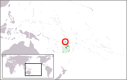
Uea is a high rocky offshore island of Rotuma. Uea is one of a number of outliers lying off the west coast of Rotuma. It is the second largest island and is the highest island in the Rotuma Group with an elevation of 260 metres (850 ft).[1]
The endemic bird Rotuma myzomela (Myzomela chermesina) is found only on the main island of Rotuma and Uea.[2]
The geological features and the beach forests of the island contribute to its national significance as outlined in Fiji's Biodiversity Strategy and Action Plan.[3]
References
[edit]- ^ "A Preliminary Checklist of the Flora of Rotuma with Rotuman Names" (PDF). Pacific Science. 54 (4): 345–363. 2000. Archived from the original (PDF) on September 18, 2009.
- ^ "Myzomela chermesina". Nature Fiji. Retrieved 2 February 2013.
- ^ Ganilau, Bernadette Rounds (2007). Fiji Biodiversity Strategy and Action Plan (PDF). Convention on Biological Diversity. pp. 107–112. Retrieved 28 May 2017.
