Frederikssund Municipality
Frederikssund Municipality
Frederikssund Kommune (Danish) | |
|---|---|
 | |
 | |
| Coordinates: 55°50′13″N 12°03′55″E / 55.8369°N 12.0653°E | |
| Country | Denmark |
| Region | Hovedstaden |
| Established | 1 January 2007 |
| Seat | Frederikssund |
| Government | |
| • Mayor | John Schmidt Andersen (1 January 2014-) (V) |
| Area | |
| • Total | 250.61 km2 (96.76 sq mi) |
| Population (1. January 2024)[1] | |
| • Total | 46,358 |
| • Density | 180/km2 (480/sq mi) |
| Time zone | UTC+1 (CET) |
| • Summer (DST) | UTC+2 (CEST) |
| Municipal code | 250 |
| Website | www |
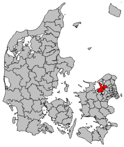
Frederikssund Kommune (Danish pronunciation: [fʁeðʁekˈsɔnˀ kʰoˈmuːnə]) is a municipality (Danish: kommune) on the shores of Roskilde Fjord in the northern part of the island of Zealand (Sjælland) in eastern Denmark. On 1 January 2007, the municipality was enlarged to include the old Jægerspris, Slangerup, and Skibby municipalities. It now covers an area of 250 km2 and has a population of 46,358 (1. January 2024). As of 1 January 2014 its mayor is John Schmidt Andersen, a member of the agrarian liberal Venstre political party. Frederikssund municipality belongs to Region Hovedstaden (Capital Region).
The seat of its municipal council is the town of Frederikssund with a population of 15,283 (1 January 2009).[2] The town is connected to the Hornsherred peninsula by the Kronprins Frederik bridge. The former municipalities of Jægerspris and Skibby are located on this peninsula.
Locations
[edit]The ten largest locations in the municipality are:
| Nr (#) | City | Population (2011) |
|---|---|---|
| 1 | Frederikssund | 15,468 |
| 2 | Slangerup | 6,822 |
| 3 | Jægerspris | 4,065 |
| 4 | Skibby | 3,185 |
| 5 | Græse Bakkeby | 2,368 |
| 6 | Kulhuse | 912 |
| 7 | Skuldelev | 905 |
| 8 | Gerlev | 783 |
| 9 | Store Rørbæk | 570 |
| 10 | Over Dråby Strand | 442 |
Politics
[edit]Municipal council
[edit]Frederikssund's municipal council consists of 23 members, elected every four years.
Below are the municipal councils elected since the Municipal Reform of 2007.
| Election | Party | Total seats |
Turnout | Elected mayor | |||||||||
|---|---|---|---|---|---|---|---|---|---|---|---|---|---|
| A | B | C | E | F | O | V | Ø | ||||||
| 2005 | 13 | 1 | 3 | 1 | 1 | 8 | 27 | 72.2% | Ole Find Jensen (A) | ||||
| 2009 | 10 | 3 | 3 | 2 | 5 | 23 | 67.1% | ||||||
| 2013 | 8 | 1 | 1 | 1 | 3 | 8 | 1 | 73.4% | John S. Andersen (V) | ||||
| 2017 | 8 | 1 | 1 | 1 | 2 | 9 | 1 | 72.6% | |||||
| Data from Kmdvalg.dk 2005, 2009, 2013 and 2017 | |||||||||||||
Recent developments
[edit]The new harbour square provides the finishing touches to the harbour developments which began in the 1990s. There are also ambitious plans to build a new residential development to the south of Frederikssund in Vinge north of Store Rørbæk. Vinge Station on the C line of the S-train was opened 14 December 2020.[3]
Twin towns – sister cities
[edit]Frederikssund is twinned with:[4]
Gallery
[edit]-
Frederikssund's main pedestrian street
-
Kulhuse
See also
[edit]References
[edit]- ^ BY2: Population 1. January by municipalities The Mobile Statbank from Statistics Denmark
- ^ "BEF44: Population 1st January, by urban areas" database from Statistics Denmark
- ^ New Town in the Øresund Region - housing potential in the new town next to Frederikssund Archived 16 June 2007 at the Wayback Machine - Paper presented at the ENHR conference, Ljubljana July 2006 Retrieved 9 January 2007.
- ^ "Internationale samarbejder". frederikssund.dk (in Danish). Frederikssund Kommune. Archived from the original on 14 April 2021. Retrieved 14 April 2021.
External links
[edit]- Municipal statistics: NetBorger Kommunefakta, delivered from KMD aka Kommunedata (Municipal Data)
- Municipal mergers and neighbors: Eniro new municipalities map
- Road map from Google maps
- The new Frederikssund municipality's official website (Danish only)
- Frederikssund / Hornsherred Tourist Bureau
- Frederikssund Gymnasium Archived 20 August 2005 at the Wayback Machine
- Center Bowl
- Frederikssund Golf Club Archived 9 March 2005 at the Wayback Machine
- Photos
- The local public library (in Danish)
- Frederikssund marina (in Danish)


