Turbary Park
Appearance

Turbary Park is an area of West Howe, Bournemouth in Dorset. Turbary Park is south of Kinson and north of Wallisdown.
Geography
[edit]
Turbary Common is the largest area of heathland in North Bournemouth. It is also a Site of Special Scientific Interest.[1] The habitats include scrub, wooded areas and both wet and dry heath.[2]
Facilities
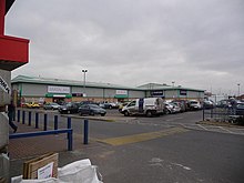
[edit]Turbary Park is served by the Turbary Retail Park.[3] Also in the area is the NHS Turbary Park Medical Centre.[4]
Politics
[edit]Turbary Park is part of the Bournemouth West constituency. Turbary Park is part of the Kinson ward which elects three councillors to Bournemouth, Christchurch and Poole Council.[5]
References
[edit]- ^ "Turbary Common". www.bournemouth.gov.uk. Retrieved 6 October 2020.
- ^ "Turbary Common". Bournemouth. Retrieved 6 October 2020.
- ^ "View Turbary Retail Park, Bournemouth on Completely Retail". completelyretail.co.ukundefined. Retrieved 6 October 2020.
- ^ NHS (28 September 2009). "Contact details - Turbary Park Centre - NHS". www.nhs.uk. Retrieved 6 October 2020.
- ^ "Kinson (Ward, United Kingdom) - Population Statistics, Charts, Map and Location". citypopulation.de. Retrieved 9 May 2021.
50°45.1′N 1°55.1′W / 50.7517°N 1.9183°W

