Tulang Bawang River
| Tulang Bawang River Sungai Tulangbawang, Wai Tulangbawang, Wai Toelangbawang, Tolangbawang | |
|---|---|
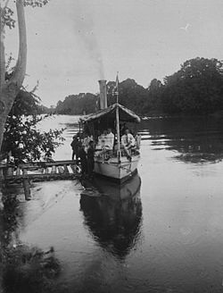
 Tulang Bawang River at Menggala (1922) | |
| Native name | Way Tulang Bawang (Lampung Api) |
| Location | |
| Country | Indonesia |
| Province | Lampung South Sumatra |
| Physical characteristics | |
| Mouth | Java Sea |
• coordinates | 4°24′26″S 105°50′40″E / 4.40722°S 105.84444°E |
| Length | 136 km |
| Basin size | 10,150 km2[1] |
| Discharge | |
| • location | Near mouth |
| • average | (Period: 1971–2000)476.8 m3/s (16,840 cu ft/s)[2] |
The Tulang Bawang River (Lampungnese: Way Tulang Bawang) is a river which mostly flows in Lampung, Indonesia.[3] The river lends its name to the Tulang Bawang Regency, where it reaches the Java Sea and the West Tulang Bawang Regency. It also flows across the capital of the regency at Menggala.[4]
One of the largest rivers in the province, it is primarily utilized by locals as a source of irrigation with little use as a waterway.[5]
History
[edit]Around the 1750s, the Dutch East India Company (VOC) competed with the British Empire and the more local Palembangese for influence in Lampung, particularly in the pepper trade. Initially they were seen as less desirable to the locals of Tulang Bawang due to their tendency to avoid local conflicts. In 1751 a Dutch post was assaulted and captured by a local prince.[6]
It was not until the mid-1800s when the Dutch East Indies managed to subjugate the locals and established formal administration over the banks. At the turn of the twentieth century, the banks of Tulang Bawang and its tributaries were settled by about 30,000 people, in comparison to the relatively unpopulated regions further away from the rivers. They were mostly inland Abung people living in indigenous houses.[7]
Geography
[edit]The river flows in the southeast area of Sumatra with predominantly tropical rainforest climate (designated as Af in the Köppen-Geiger climate classification).[8] The annual average temperature in the area is 25 °C. The warmest month is September, when the average temperature is around 28 °C, and the coldest is January, at 22 °C.[9] The average annual rainfall is 3248 mm. The wettest month is December, with an average of 547 mm rainfall, and the driest is September, with 40 mm rainfall.[10]
See also
[edit]Notes and references
[edit]- ^ Atlas Sumberdaya Wilayah Pesisir Lampung (in Indonesian).
- ^ "Sumatra".
- ^ Wai Tulangbawang - Geonames.org.
- ^ Sungai Tulangbawang - OpenStreetMap. 2011.
- ^ Yasland, Mursalin (3 February 2017). "Dua Sungai di Lampung Jadi Transportasi Publik". Republika (in Indonesian). Retrieved 5 October 2017.
- ^ Atsushi, Ota (2006). Changes of regime and social dynamics in West Java : society, state, and the outer world of Banten, 1750-1830. Leiden: Brill. pp. 68, 92. ISBN 9789004150911.
- ^ Kusworo, Ahmad (2014). Pursuing Livelihoods, Imagining Development: Smallholders in Highland Lampung, Indonesia. ANU E Press. p. 20. ISBN 9781925021486. Retrieved 5 October 2017.
- ^ Peel, M C; Finlayson, B L; McMahon, T A (2007). "Updated world map of the Köppen-Geiger climate classification". Hydrology and Earth System Sciences. 11 (5): 1633–1644. Bibcode:2007HESS...11.1633P. doi:10.5194/hess-11-1633-2007.
- ^ "NASA Earth Observations Data Set Index". NASA. 30 January 2016.
- ^ "NASA Earth Observations: Rainfall (1 month - TRMM)". NASA/Tropical Rainfall Monitoring Mission. 30 January 2016.


