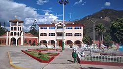
Tinco District
Appearance
Tinco
Tinku | |
|---|---|
 Tinco | |
Location within Peru | |
| Coordinates: 9°16′14.56″S 77°40′40.22″W / 9.2707111°S 77.6778389°W | |
| Country | |
| Region | Ancash |
| Province | Carhuaz |
| Founded | September 30, 1941 |
| Capital | Tinco |
| Government | |
| • Mayor | Agripino Rusbany Cochachin Minaya (2019-2022) |
| Area | |
• Total | 15.44 km2 (5.96 sq mi) |
| Elevation | 2,588 m (8,491 ft) |
| Population | |
• Total | 3,145 |
| • Density | 200/km2 (530/sq mi) |
| Time zone | UTC-5 (PET) |
| UBIGEO | 020610 |
Tinco District is one of eleven districts of the province Carhuaz in Peru.[1]
References
[edit]- ^ (in Spanish) Instituto Nacional de Estadística e Informática. Banco de Información Distrital Archived 2008-04-10 at the Wayback Machine. Retrieved April 11, 2008.
9°33′19″S 77°39′17″W / 9.5554°S 77.6548°W


