
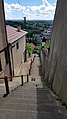
Thiers ramparts
| Thiers ramparts | |
|---|---|
| Thiers, Puy-de-Dôme, Auvergne-Rhône-Alpes, France | |
_armorial_de_Revel.jpg) The town of Thiers with its castle and ramparts circa 1450 | |
| Coordinates | 45°51′15″N 3°32′57″E / 45.85417°N 3.54917°E |
| Site information | |
| Owner | Private property, city of Thiers |
| Site history | |
| Built | 17th century |
| In use | Medieval, Baroque and Neoclassical architecture |
| Designations | Thier outstanding heritage site; part included on the list of MH |
The Thiers ramparts are fortifications erected between the 11th and 16th centuries to protect the town of Thiers in the Puy-de-Dôme department, France.
Since the 11th century, the town has undergone a process of concentric expansion around the ramparts of the lord's castle and the Saint-Genès church. As new villages were established near the city walls, the fortified town underwent at least five periods of expansion. The least well-maintained sections of the walls were demolished in the late 18th century, with the majority of urban redevelopment in the 19th century resulting in the destruction of several segments of the northern wall and the repurposing of the eastern wall. By the nineteenth century, only the eastern section of the fortifications remained intact, primarily serving as a retaining wall for the sloping terrain of the town.
The entire structure of the town's ramparts has been designated a notable heritage site and is overseen by the local urban planning and heritage conservation plan (PSMV).
History
[edit]First Enclosure
[edit]
In the 11th century, the initial fortification was constructed, encompassing both the feudal castle and the Saint-Genès church. Two Romanesque gates were built in this initial wall, allowing passage to the path that led to the town. During the 15th century, it was designated as the "wall of the Palace of Chastel." The primary thoroughfare of this inaugural district of the city is named in commemoration of this structure; it is currently known as the "Rue du Palais," although it should be referred to as the "Rue du Palais du Chastel."[a 1][b 1]
The configuration of the streets and squares within the wall does not appear to have been planned according to a strict and pre-established scheme. The initial path remained in the same location; even the construction of the first wall did not result in a significant alteration to the general direction of the path, which entered the enclosure through the "Porte de la Bout" (demolished at the end of the 19th century) at the top of the current rue du Palais and exited by the "Square Tower of the Chancellery" in front of the current rue du Bourg. The gate, now backfilled and walled up, can still be seen above the Place du Pirou. The space between the Chastel Palace and the church has always remained open. From the outset, this space was used as a public gathering place in times of peace, but it also served as a refuge for local farmers bringing their herds to safety in times of insecurity. In the 15th century, it was transformed into a cemetery.[a 2]
Second enclosure
[edit]
At the beginning of the 13th century, the town experienced a period of expansion to the north, resulting in the construction of a new wall surrounding the existing houses. This new neighborhood was served by a significant freshwater spring, later channeled into the Pirou fountain, located close to the initial wall. The primary thoroughfare of this urban expansion is Rue du Bourg. Two further principal thoroughfares were subsequently constructed: the Rue du Pourcharesse (subsequently renamed Rue Lasteyras) and the Rue du Transvaal (subsequently renamed Rue du Bourg). During this period, the appellations assigned to streets in the city frequently derived from geographical sources, either denoting the location of the street or the neighborhood it served. In Thiers, it is uncommon for a street to retain the same designation since the fifteenth century.[a 3][a 4]
Third enclosure
[edit]In the fourteenth century, a new neighborhood was forming in the relatively protected angle to the east by the "wall of the Palace of Chastel" and to the north by the "wall of the Palace of Bourg." To protect this expansion, a new wall was constructed, known as the "new wall of the city of Thiart," which constitutes the city's third wall.[a 5]
Upon the erection of a new wall, new houses were constructed on either side of the now disused old wall. Initially, a "relay" was left along the old wall. The configuration of the houses resulted in the formation of a new street on either side, situated parallel to the original wall. Furthermore, the wall could serve as the foundation for the facades of houses. At this juncture, the new street followed the remains of the old wall, as evidenced by the second and third walls. The layout of the streets in Thiers remained profoundly shaped by the fortifications, which held unparalleled importance in the city's urban planning. These defensive structures were constructed under the existing space to be protected, optimizing the utilization of the terrain. Religious considerations and military necessities directed the city's development, and although this is now largely overlooked, it is still discernible in the city's topography, which can be characterized as picturesque.[a 6][1]

Fourth enclosure
[edit]In the fifteenth century, the city's expansion was such that a fourth wall was constructed, encompassing the previous three. This final wall, covering a significantly larger area than the preceding ones, was promptly designated the "city wall." The wall's construction was initiated by Louis II of Bourbon around 1400. At that time, the city was experiencing the final in a series of devastating wars, later known as the Hundred Years' War.[c 1]
Fifth enclosure
[edit]In the sixteenth century, the lordship initiated the construction of a final defensive wall to safeguard the recently developed residential areas on the eastern mountainside, close to the Durolle River and the Vallée des Usines. Despite its relatively modest dimensions, this wall represented the closest defensive structure to the aforementioned locations.[b 1][2]
Other defensive elements
[edit]The city's walls and gates were reinforced with protective elements from their construction. These included embrasures, called bouches à feu in the region, which allowed archers or gunners to fire. As Michel Combronde notes in Représentation graphique de la porte Neufve au début du XVe siècle, many loopholes were also in the city's towers and walls.[3]
The work of historian André Kristos draws attention to several examples of what are known as brayettes. It would appear that these are false braies, a term that was used in the 15th century to describe such structures. They constitute an embankment or retaining wall that encircles a fortified camp. In the context of premodern fortification, this ante-chamber was situated between the moat and the primary defensive wall of a fortress. The brayette was positioned lower than the main wall to defend it from the moat.[4] Two brayettes were discovered in Thiers. The first, called the "brayette du Chastel," surrounded and protected the Chapter Tower of the first wall, and the second, the "brayette du Bourg," situated further north, protected the Montauld Tower of the second wall.[a 4]
Final reinforcements and partial dismantling
[edit]
The Wars of Religion commenced in 1562 in France.[5] The inhabitants of Thiers were particularly susceptible to the influence of the "new ideas" due to their openness to external influences, particularly those emanating from the Lyon basin. As early as 1551, Antoine Chabrol, a cutler from Thiers, elected to flee to Switzerland. He was among the initial cohort of Protestant migrants seeking asylum in the country between 1549 and 1556. In the subsequent years, numerous individuals from Thiers migrated to Geneva.[6] The city promptly augmented its fortifications to deter an incursion by the Huguenots, who increasingly threatened the city. Nevertheless, in 1568, they managed to gain entry and wreaked havoc on a portion of it.[7]
From the 17th century onwards, Thiers experienced urban expansion as a consequence of significant economic growth driven by the flourishing cutlery industry in the region.[8] As the population increased, the city undertook various improvements to facilitate movement within the city walls, such as constructing the Saint-Genès pedestrian route (see below). At the end of the 18th century, the city planned the destruction of part of the walls to prevent the collapse of poorly maintained sections and to widen traffic routes. Other parts of the walls were also destroyed to create streets in their place, such as Rue Grenette and Rue Pasteur.[a 4]
In the nineteenth century, the northern section of the fourth wall was almost entirely demolished to facilitate the construction of new thoroughfares, including the roads, rue Victor-Hugo, and rue Prosper-Marilhat.[c 2] Consequently, establishing Imperial Road No. 89 – subsequently designated as National Road 89 in 1824 – necessitated the destruction of five defensive towers and two gates.[c 3]
Despite the partial destruction of Thiers' walls, the majority of these fortifications and their associated towers remain intact to this day. The towers are currently utilized for residential purposes, as evidenced by the Pignat Tower. The walls, meanwhile, serve two distinct functions. Primarily, they support the underlying land on which the city is constructed. Secondly, they offer a foundation for buildings erected directly on the wall.[2]
Protection and enhancement of heritage
[edit]In 1820, a section of the fourth wall was rebuilt, predominantly comprising the structures that supported the city's eastern land holdings.[9]
The urban wall of Thiers is notable for its high degree of preservation, with nearly two-thirds of its original structure remaining intact. Despite the destruction of several segments during the 19th century, the wall remains one of the most well-preserved examples in the Auvergne region. From the Vallée des Usines to the east and the Limagne plain to the west, the city of Thiers is visible as it is built on a rocky spur surrounded by a belt of walls.[7][10] This is particularly evident on rue Anna-Chabrol and rue des Murailles, which retain the entirety of the walls that support them.[11][1][12]
The entire city's walls are classified as a remarkable heritage site and managed by the urban planning and heritage conservation plan (PSMV).[13][14] This program contributes to protecting and enhancing the city's historical heritage, of which the walls are a part.[14] However, only a segment of the walls is classified as a historic monument, given that part of the urban fabric rests on the walls.
The Thiers tourist office regularly organizes tours of the medieval city. This tour, entitled "Thiers, the Medieval", provides an insight into the diversity and richness of the upper city's heritage. The tour route encompasses streets where the walls are well preserved, affording the tourist guide the opportunity to provide a concise historical overview of the city's walls and their evolution.[15]
| Protected elements | State | Protection | Date |
|---|---|---|---|
| Saint-Jean church in Thiers | Closed to the public | Listing | October 27, 1986 |
| 12 Rue de la Coutellerie | Collapsed in 2012 | Listing | July 13, 1926 |
| 14 Rue de la Coutellerie | Collapsed in 2012 | Classification | August 9, 1922 |
| Cutlery Museum | Houses part 2 of the Cutlery Museum | Listing | March 21, 1983 |
| Lauzun House | In good condition | Listing | July 13, 1926 |

Detailed map
[edit]| Detailed map of the ramparts and inner city of Thier |  | ||
| Remaining elements | Disappeared elements | ||
|---|---|---|---|
| 1: Chastel Palace | A: Chapter Tower | ||
| 2: Square Tower of the Chancellery | B: Bout Gate | ||
| 3: Clock Tower | A: Bourg Portal | ||
| 4: Yrison Tower | B: City Tower | ||
| 5: Chastelain Tower | C: Tower Under the Market Hall | ||
| 6: (Unnamed) Tower | D: Salement Gate | ||
| 7: Pedde Saint-Genès | A: Limagne or Lymagne Gate | ||
| 1: Pedde du Coin des Hasards | B: Tower 2 | ||
| 2: Maistre Raymond Tower | C: Tower 1 | ||
| 3: Guet Tower | A: Allepit II Tower | ||
| 4: Pignat Tower | B: Neufve Gate | ||
| 5: Montauld Tower | C: Poule Tower | ||
| 1: Tower 3 | D: City Tower | ||
| 1: Porte Malorie | E: Lac Portal | ||
| 2: Malorie Tower | F: Town Hall Tower | ||
| 3: Coagne Gate | G: Lyon Gate | ||
| 4: Coagne Tower | H: Tower under the hospital | ||
| 5: Saint-Jean Gate | |||
| 6: Allepit I Tower | |||
| 1: Saint-Jean Church | |||
| 2: Seychal Gate | |||
Remaining elements
[edit]The following elements are described in a clockwise direction, commencing with the Square Tower of the Chancellery, situated to the north of the initial enclosure. It should be noted that not all of the walls belong to the city of Thiers and are therefore inaccessible during guided tours or at the discretion of the public. Furthermore, the walls are not fully visible from traffic routes. It is also notable that many elements are integrated into the urban landscape.
First enclosure
[edit]A significant proportion of the original structure has been lost or obscured, with only a limited area remaining accessible today. The following table provides an overview of the current status of the surviving elements, along with their accessibility in 2018.
| Element | Owner | Accessibility | Coordinates |
|---|---|---|---|
| Square Tower of the Chancellery | Private property | Integrated into the urban space
Partially visible from Rue du Pirou (entrance blocked 3 meters above the street) |
45°51′15″N 3°32′52″E / 45.85417°N 3.54778°E |
| Eastern curtain wall of the Square Tower of the Chancellery | Private property, public road | Integrated into the urban space
Partially destroyed to allow passage on Rue du Palais |
|
| Clock Tower | Private property
City of Thiers |
Integrated into the urban space
North and west sides visible via Rue du Pirou South side visible from Place du Palais |
45°51′15″N 3°32′53″E / 45.85417°N 3.54806°E |
| Eastern curtain wall of the Clock Tower | Private property
City of Thiers |
Visible from the courtyard behind the Tribunal | |
| Yrison Tower | Private property
City of Thiers |
Partially destroyed, only a wall section remains, visible from an interior courtyard | 45°51′15″N 3°32′54″E / 45.85417°N 3.54833°E |
| Southeastern curtain wall of the Yrison Tower | Private property
City of Thiers |
Now serves as a retaining wall, visible behind Saint-Genès Church | |
| Chastelain Tower | Private property | Partially visible from No. 13, Rue du Palais | 45°51′15″N 3°32′52″E / 45.85417°N 3.54778°E |
| Western curtain wall of the Chapter Tower | Private property, public road | Partially visible from Place Lafayette | |
| Western curtain wall of the Chastelain Tower | Private property | Hidden behind buildings on Rue de la Coutellerie | |
| (Unnamed) Tower | Private property | Wall section visible from No. 42, Rue de la Coutellerie | 45°51′10″N 3°32′52″E / 45.85278°N 3.54778°E |
| Southern curtain wall of the Bout Tower | Private property | Partially visible from Rue de la Coutellerie | |
| Pedde Saint-Genès | Private property, public road | Very well preserved, staircase passage underneath accessible to pedestrians | 45°51′13″N 3°32′55″E / 45.85361°N 3.54861°E |
| Northern curtain wall of the Bout Tower | Private property | Partially visible from Rue de la Coutellerie (where buildings destroyed in 2012 revealed the presence of this wall) | |
| For all the points mentioned on this page: view on OpenStreetMap [archive], Bing Cartes [archive], or download in KML format. | |||
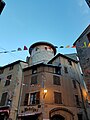
Square Tower of the Chancellery
[edit]The Chancellery Tower, constructed as early as the 11th century, represents the northern exit of the "murailhe de palais du Chastel." The building's name has its origins in the 15th century. It is now highly visible from Rue du Pirou and the beginning of Place du Palais, also known as Place Saint-Genès. The shape of the entrance is highlighted by the stones that reinforce the contours of the main door.[16] It is currently the oldest inhabited house in the entire town.[a 2]
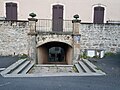
Pedde Saint-Genès
[edit]In Thiers, a "pedde" is a passageway that traverses a street or alley at varying elevations. The Pedde Saint-Genès was originally a gateway of the initial enclosure, though it was constructed with openings around the 17th century to facilitate commerce between the original village and the subsequent expansions of the town to the east.[c 4] Presently, this pedde persists between Rue Mancel-Chabot and Place du Palais.[17]
Clock Tower
[edit]Following a renovation project completed in 2017, the tower is now more visible from Place du Pirou as a result of the raised roof. The lower part of the tower is constructed from granite stones, while the upper part is topped with a brown wooden structure with small openings closed by wooden shutters painted red.[18]
-
 The square tower of the Chancellery.
 -
 The Saint-Genès pedde.
 -
 The clock tower.
 -
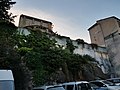 Traces of the first wall behind the church of Saint-Genès
 -
 The town of Thiers in the 18th century. The castle keep and clock tower can be seen in the top right-hand corner of the image.


Second enclosure
[edit]| Element | Owner | Accessibility | Coordinates |
|---|---|---|---|
| Charnier Gate/Pedde du Coin des Hasards | Private property, public road | Integrated into the urban space
Fairly well preserved, passage underneath accessible to pedestrians and vehicles |
45°51′15″N 3°32′54″E / 45.85417°N 3.54833°E |
| Southern curtain wall of the Maistre Raymond Tower | Private property | Integrated into the urban space
Partially visible from the courtyard behind the Tribunal |
|
| Maistre Raymond Tower | Private property
City of Thiers |
Very well preserved, visible from the lower part of Rue Alexandre-Dumas and the upper part of Rue Durolle | 45°51′16″N 3°32′55″E / 45.85444°N 3.54861°E |
| Southern curtain wall of the Pignat Tower | Private property | Integrated into the urban space
Hidden behind buildings on Rue Alexandre-Dumas |
|
| Pignat Tower | Private property
City of Thiers |
Very well preserved, highlighted on Rue Alexandre-Dumas during the 2018 renovation works | 45°51′17″N 3°32′54″E / 45.85472°N 3.54833°E |
| Southern curtain wall of the Montauld Tower | Private property | Integrated into the urban space
Hidden behind buildings on Rue Alexandre-Dumas |
|
| Montauld Tower | Private property | Partially visible from the roof of the Municipal Media Library of Thiers | 45°51′18″N 3°32′53″E / 45.85500°N 3.54806°E |
| Salement Gate | Public road | Small wall section visible from the beginning of Rue de la Coutellerie | 45°51′14″N 3°32′51″E / 45.85389°N 3.54750°E |
| Watch Tower | Private property | Visible from Rue Alexandre-Dumas | 45°51′16″N 3°32′54″E / 45.85444°N 3.54833°E |
| For all the points mentioned on this page: view on OpenStreetMap [archive], Bing Cartes [archive], or download in KML format. | |||
Charnier Gate and Pedde du Coin des Hasards
[edit]The structure comprises a gate and a covered passageway connecting two buildings situated above an alleyway. This architectural ensemble is emblematic of a "pedde" in Thiers, and it is designated as Charnier Gate, which was originally part of the Maistre Raymond Tower. The structure is attached to the north side of the Maistre Raymond Tower (13th century) and the south side of a former entrance to the seigneurial castle of Thiers.[19] The pedde is comprised of four floors, with the smallest floor situated at the lowest level and the largest at the top (4th floor). As is the case with numerous half-timbered houses, the pedde's floors are constructed with corbel arches.
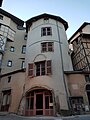
Maistre Raymond Tower
[edit]Following extensive renovations in the early 21st century, the Maistre Raymond Tower is now largely visible from the small square it overlooks. It comprises four upper floors constructed on a ground floor that is fully accessible to the public via a large porch supported by a stone vault.[20]
Pignat Tower
[edit]The Pignat Tower is the most imposing of the second enclosure due to its diameter, which exceeds 10 metres, a relatively large diameter in comparison to the other towers. In 2018, the tower was renovated, and its original colour (faded red) was replaced with white, which makes the tower more visible from the street.[21]
-
 The Pignat tower.
 -
 The Maistre Raymond tower.
 -
![The rear of the Pedde du Coin des Hasards [fr].](//upload.wikimedia.org/wikipedia/commons/thumb/a/aa/La_pedde_du_coin_des_hasards.jpg/120px-La_pedde_du_coin_des_hasards.jpg) The rear of the Pedde du Coin des Hasards.
The rear of the Pedde du Coin des Hasards. -
 The Watch Tower.


![The rear of the Pedde du Coin des Hasards [fr].](/wiki/File:La_pedde_du_coin_des_hasards.jpg)

Third enclosure
[edit]The third enclosure is the smallest in the city in terms of the area it protects. It comprises a tower, situated at the corner of Rue du Docteur Lachamp and Rue de la Faye, which has three floors. It is the smallest of the towers, with a diameter of just over 3 meters, and contains a staircase allowing residents of the outer districts to enter the fortified town.[a 7]
| Element | Owner | Accessibility | Coordinates |
|---|---|---|---|
| Southern curtain wall of the Chastelain Tower | Private property | Integrated into the urban space | |
| Tower 3 | Private property
City of Thiers |
Very well preserved, visible from Rue du Docteur-Lachamp | 45°51′10″N 3°32′49″E / 45.85278°N 3.54694°E |
| Curtain wall 1 | Private property | Integrated into the urban space | |
| Southern curtain wall of the Limagne or Lymagne Gate | Private property | Integrated into the urban space, very visible from the lower part of Rue du Docteur-Lachamp | |
| Northern curtain wall of the Limagne or Lymagne Gate | Private property | Integrated into the urban space, very visible from the middle of Rue du Docteur-Lachamp | |
| For all the points mentioned on this page: view on OpenStreetMap [archive], Bing Cartes [archive], or download in KML format. | |||
Fourth enclosure
[edit]| Element | Owner | Accessibility | Coordinates |
|---|---|---|---|
| Porte Malorie | Public road | Urban integration
Beginning of the vault and narrowing of the alley indicating the presence of a medieval gate between the bottom of Rue Gambetta and the top of Rue Rouget-de-l'Isle |
45°51′12″N 3°32′45″E / 45.85333°N 3.54583°E |
| North curtain wall of Malorie Tower | Public road | Very visible from rue Chauchat | |
| Malorie Tower | Private property | Very well preserved, visible from the bottom of rue Gambetta and the top of rue Rouget-de-l'Isle | 45°51′12″N 3°32′44″E / 45.85333°N 3.54556°E |
| Southeast curtain wall of Coagne Tower | Public road | Very visible from rue Anna-Chabrol | |
| Coagne Gate | Public road | Partially preserved, support wall still visible near Place de Coagne | 45°51′08″N 3°32′48″E / 45.85222°N 3.54667°E |
| North curtain wall of Saint-Jean Gate | Public road | Very visible from rue des Murailles | |
| Coagne Tower | Private property | Fully preserved, restored in 2016 | 45°51′05″N 3°32′53″E / 45.85139°N 3.54806°E |
| South curtain wall of Tower 3 | Public road | Very visible from rue des Treilles, across from Centre A school | |
| Saint-Jean Gate | Public road | Urban integration
Beginning of the vault and narrowing of the alley indicating the presence of a medieval gate |
45°51′04″N 3°32′59″E / 45.85111°N 3.54972°E |
| South curtain wall of Neufve Gate | Public road | Partially destroyed
Visible from rue Prosper-Marilhat |
|
| South curtain wall of Alepit Tower | Public road | Very visible from rue de la Bienfaisance | |
| Alepit II Tower | Private property | Visible between rue Terrasse and rue de la Bienfaisance | |
| For all the points mentioned on this page: view on OpenStreetMap [archive], Bing Cartes [archive], or download in KML format. | |||
Malorie Tower
[edit]Malorie Tower is in the lowest altitude among other towers situated at a higher elevation. It is also one of the most well-preserved, exhibiting preserved arrow slits close to the ground on the right side. Additionally, the tower marks the entrance to an underground passageway connecting the summit of Rue Rouget-de-l'Isle to the Chastel Palace, an early 11th-century structure. This entrance is currently visible from the street, although it is enclosed by a fence.
Saint-Jean Gate
[edit]The gate was annexed in the 16th century to the church of the same name and can still be observed from the bottom of Place Saint-Jean. A suggestion of a vault is visible between the church and the remainder of the wall.[22] Two unaltered rectangular windows remain in the continuation of the gate: one on the side of Rue des Murailles and the other in a building attached to the church.[22] These apertures served as vents for the discharge of flammable liquids, thereby repelling enemies approaching the gate.
-
 Rue Chauchat with part of the fourth wall on the right.
 -
 The Coagne tower overlooking the Vallée des Usines, taken in 2018.
 -
 Part of the fourth enclosure with the Coagne tower on the right in 1910.
 -
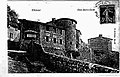 The Malorie tower at the end of the 19th century.


Fifth Enclosure
[edit]| Element | Owner | Accessibility | Coordinates |
|---|---|---|---|
| Saint-Jean Church in Thiers | Private property
City of Thiers |
Church integrated into the wall, closed to the public | 45°51′04″N 3°32′58″E / 45.85111°N 3.54944°E |
| Curtain wall of Saint-Jean Church | Private property
City of Thiers |
Church integrated into the wall | |
| South curtain wall of Seychal Gate | Private property
City of Thiers |
Very visible from the north part of rue des Murailles | |
| Seychal Gate | Public road | Partially preserved, support wall still visible from Place du Corps-de-Garde and rue Durolle | 45°51′17″N 3°32′59″E / 45.85472°N 3.54972°E |
| North curtain wall of Seychal Gate | Private property
City of Thiers |
Very visible from the primary school of Centre A | |
| For all the points mentioned on this page: view on OpenStreetMap [archive], Bing Cartes [archive], or download in KML format. | |||
Saint-Jean Church
[edit]
The church, originally constructed in the Romanesque style, was destroyed and subsequently rebuilt in the 15th century in the Gothic style. However, it was then incorporated into the fortifications in the following century, forming part of the comprehensive closure of the final enclosure.[c 2] The dual purpose of the church is still evident at the rear of the choir, where the walls are reinforced.[23]
Disappeared elements
[edit]First enclosure
[edit]| Element | Location | Notes |
|---|---|---|
| Chapter Tower | Rue Mancel-Chabot | This tower was protected by the "Brayette du Chastel," a type of defense preventing enemies from approaching the tower. Its usefulness was questioned during the construction of the fourth enclosure and it was then destroyed, making way for new dwellings.[a 3] |
| Bout Tower and Gate | Petite Rue du Palais | This tower was originally built along the only path leading visitors to the town and its fortified castle. It was accompanied by a gate that shares its name.[a 3] |
Second enclosure
[edit]| Element | Location | Notes |
|---|---|---|
| Bourg Portal | Rue du Bourg | This gate allowed visitors to enter via a drawbridge overlooking the "Rif des Boucheries," which flows at the bottom of a ravine. This became National road 89 in the 19th century.[a 4] |
| City Tower | Rue Lasteyras | This tower — likely square-shaped — was built in the 13th century at the end of Rue Lasteyras, which formed after successive city expansions.[a 4] |
| Tower Under the Market Hall | Place des Martyrs de la Déportation | This tower was originally built under a market hall, hence its name. Upon its construction, it was the lowest tower in the city in terms of altitude before the fourth enclosure was built.[a 4] |
Third enclosure
[edit]| Element | Location | Notes |
|---|---|---|
| Tower 1 | Rue de la Coutellerie | Small tower in the lower part of Rue de la Coutellerie.[2] |
| Tower 2 | Place Lafayette | Tower at what is now the site of the second part of the Cutlery Museum overlooking Place Lafayette.[2] |
| Limagne or Lymagne Gate | Rue du Docteur-Lachamp | Gate providing access to the city via the Limagne plain.[2][a 8] |
Fourth enclosure
[edit]| Element | Location | Notes |
|---|---|---|
| Poule Tower | Place Duchasseint | Tower located just above a water source that supplied part of the city.[a 6] |
| City Tower | Rue François-Mitterrand | Tower destroyed in the 19th century for the passage of Route Impériale No. 89.[a 4] |
| Lac Portal | Rue François-Mitterrand | Gate destroyed in the 19th century for the passage of Route Impériale No. 89.[a 4] |
| Neufve Gate | Place Belfort | Gate destroyed in the 19th century for the passage of Route Impériale No. 106. |
| Alepit I Tower | Rue Prospère-Marilhat | Tower destroyed in the 19th century for the passage of Rue Prospère-Marilhat. |
| Tower Under the Hospital | Thiers old hospital | Tower destroyed to expand the maternity ward and emergency room of the hospital at the end of the 19th century. |
| Town Hall Tower | Place Antonin-Chastel | Tower destroyed in the 19th century for the passage of Route Impériale No. 89.[a 4] |
| Lyon Gate | Rue Durolle | Gate destroyed to widen Rue Durolle. |
In the arts
[edit]
The medieval town's ramparts, particularly the eastern and southern walls, are regarded as a symbol by travelers and artists. They are situated in an atypical landscape, which is regularly painted, drawn, and photographed, especially for illustrating tourist guides and as subjects of postcards. This landscape is formed by the ramparts, the landscaped gardens of the Old Hospital in the foreground, and the old town and Saint-Genès Church in the background.[24]
In 1861, during her travels through the town, the French writer George Sand composed a novel about the work of the Thiers cutlers. She referred to the town's ramparts as a writing surface where a certain Audebert had inscribed "words in charcoal."[25] In 2017, the painter Monik Durand-Pradat created a series of paintings depicting various neighborhoods within the town. These included representations of still-visible parts of the ramparts, such as the Maistre Raymond Tower and the Pedde du Coin des Hasards.[26] In the same year, Anthony Mage created a painting of the town from the perspective of Margerides Rock. The ramparts along Rue des Murailles are a prominent feature of this work.[27] Hubert Jaqueton described the town of Thiers as follows: "From the summit of Grun de la Pierre-qui-danse, tourists can survey the entire townscape. They can also observe the towers that once protected the castle's enclosure and the enormous keep with its broken crenellations."[28]
Notes
[edit]References
[edit]Sources
[edit]- Association Le pays thiernois (1983). Le pays thiernois et son histoire No 1 (in French). Ville de Thiers.
- ^ Association Le pays thiernois 1983, p. 5
- ^ a b Association Le pays thiernois 1983, p. 6
- ^ a b c Association Le pays thiernois 1983, p. 7
- ^ a b c d e f g h i Association Le pays thiernois 1983, p. 8
- ^ Association Le pays thiernois 1983, p. 9
- ^ a b Association Le pays thiernois 1983, p. 12
- ^ Association Le pays thiernois 1983, p. 22
- ^ Association Le pays thiernois 1983, p. 10
- Association Le pays thiernois (1985). Le pays thiernois et son histoire No 6 (in French). Ville de Thiers.
- ^ a b Association Le pays thiernois 1985, p. 8
- Association Le pays thiernois (1984). Le pays thiernois et son histoire No 2 (in French). Ville de Thiers.
- ^ Association Le pays thiernois 1984, p. 4
- ^ a b Association Le pays thiernois 1984, p. 12
- ^ Association Le pays thiernois 1984, p. 17
- ^ Association Le pays thiernois 1984, p. 7
Other references
[edit]- ^ a b Centre France (May 31, 2012). "De la place du Corps-de-Garde à la place Saint-Jean, la rue des Murailles longe la Durolle". www.lamontagne.fr (in French). Archived from the original on November 22, 2021. Retrieved October 14, 2018.
- ^ a b c d e Service régional de l’Inventaire Auvergne (March 10, 2014). "Thiers, suivre la pente". Ville de Thiers (in French).
- ^ "Représentation de la Porte Neufve au XVe siècle par Michel Combronde". Représentation de la Porte Neufve au XVe siècle par Michel Combronde (in French). Archived from the original on November 24, 2023. Retrieved October 30, 2018.
- ^ "Le glossaire - Fortification et MémoireFortification et Mémoire". fortificationetmemoire.fr (in French). Archived from the original on September 22, 2023. Retrieved October 30, 2018.
- ^ "Europe : Guerres de Relion (repères chronologiques)". Encyclopédie Universalis (in French). Archived from the original on May 25, 2024. Retrieved November 1, 2018.
- ^ Boy, Michel (1981). Le protestantisme auvergnat et le premier refuge de Genève (in French).
- ^ a b Hadjadj, Dany (1999). Pays de Thiers : le regard et la mémoire (in French). Presses Univ Blaise Pascal. p. 160. ISBN 978-2-84516-116-0. Archived from the original on January 2, 2022.
- ^ Combe, Paul (1922). "Thiers et la vallée industrielle de la Durolle". Annales de Géographie (in French). 31 (172): 360–365. doi:10.3406/geo.1922.10136. ISSN 0003-4010. Archived from the original on June 6, 2024. Retrieved June 24, 2018.
- ^ Ytournel, Jacques (1979). Thiers en cartes postales anciennes (in French). Thiers: Ville de Thiers. p. 49. ISBN 90-288-0153-7.
- ^ "Jardins de l'Hôpital - Thiers". Film France (in French). August 30, 2017. Archived from the original on October 29, 2023. Retrieved October 14, 2018.
- ^ "Thiers - 63 Thiers Les murailles de Saint Jean Pas circulée - Carte postale ancienne et vue d'Hier et Aujourd'hui". Geneanet (in French). Archived from the original on January 2, 2022. Retrieved October 14, 2018.
- ^ Office de tourisme de Thiers (2017). Vallée des Usines (PDF) (in French). Thiers, Auvergne: Ville de Thiers. p. 1. Archived from the original (PDF) on July 30, 2016.
- ^ "Ville à Secteur Sauvegardé – Thiers – Patrimoine Aurhalpin". www.patrimoineaurhalpin.org (in French). Archived from the original on October 29, 2023. Retrieved October 14, 2018.
- ^ a b Dubreuil, Louis (2018). Site patrimonial remarquable et plan de sauvegarde et de mise en valeur de la ville de Thiers (PDF) (in French). Auvergne-Rhône-Alpe Region: Ville de Thiers. Archived from the original (PDF) on August 2, 2024.
- ^ Centre France (August 8, 2017). "Tourisme - Thiers propose de nombreuses visites régulières durant l'été, notamment sur la vieille ville". www.lamontagne.fr (in French). Archived from the original on October 4, 2024. Retrieved October 30, 2018.
- ^ "Premiere Tour de la Chancellerie". L'encyclopedie de Bourges (in French). Archived from the original on January 16, 2022. Retrieved October 4, 2024.
- ^ "Pedde Saint-Genès". La Région (in French). Archived from the original on October 4, 2024. Retrieved October 4, 2024.
- ^ "Tour de l'Horloge". Clermont Auvergne Volcans (in French). 11 April 2024. Archived from the original on May 19, 2024. Retrieved October 4, 2024.
- ^ "La pedde du Coin des Hasards". petit-patrimoine.com. October 13, 2014. Archived from the original on February 23, 2024. Retrieved February 24, 2017.
- ^ "Rue Alexandre-Dumas". La Région (in French). Archived from the original on October 4, 2024. Retrieved October 4, 2024.
- ^ "Ilot A. Dumas". www.ville-thiers.fr (in French). Archived from the original on October 13, 2018. Retrieved October 13, 2018.
- ^ a b "Eglise paroissiale Saint-Jean-du-Passet - Inventaire Général du Patrimoine Culturel". patrimoine.auvergnerhonealpes.fr (in French). Archived from the original on November 17, 2023. Retrieved August 18, 2020.
- ^ "Notice no PA00092432". Open heritage platform, Mérimée database, French Ministry of Culture. (in French). Archived from the original on November 17, 2023.
- ^ "Thiers - Recherche de cartes postales". Geneanet (in French). Archived from the original on January 2, 2022. Retrieved October 30, 2018.
- ^ Sand, George (1861). La ville noire (in French). Michel Lévy. Archived from the original on January 2, 2022.
- ^ Chevrier, Alice (December 30, 2017). "Thiers, ville modèle (7) - Thiers, Monik Durand-Pradat l'aime à l'italienne". La Montagne (in French). Archived from the original on October 4, 2024. Retrieved October 30, 2018.
- ^ Chevrier, Alice (December 29, 2017). "Thiers, ville modèle (6) - Anthony Mage peint une histoire inspirée d'une ville réelle". La Montagne (in French). Archived from the original on October 4, 2024. Retrieved October 30, 2018.
- ^ Reclus, Onésime (1900–1906). "À la France : sites et monuments. L'Auvergne (Puy-de-Dôme, Cantal) / [notices de Onésime Reclus]". Gallica (in French). Archived from the original on January 2, 2022. Retrieved November 3, 2018.
Bibliography
[edit] Definitions from Wiktionary
 Media from Commons
 News from Wikinews
 Quotations from Wikiquote
 Texts from Wikisource
 Textbooks from Wikibooks
 Resources from Wikiversity
- Collectif (2007). Mythologie française : bulletin de la Société de mythologie française (in French). Clermont-Ferrand: Société de mythologie française. p. 14. Archived from the original on October 2, 2024.
- Drillon, Caroline; Ricard, Marie-Claire (2012). L'Auvergne Pour les Nuls (in French). Clermont-Ferrand: edi8. p. 344. ISBN 978-2-7540-4485-1. Archived from the original on March 18, 2023.
- Fournier, Gabriel (1962). Le peuplement rural en Basse Auvergne durant le haut Moyen ge (in French). Clermont-Ferrand: Presses Universitaires de France. p. 587.
- Fournier, Gabriel; Revel, Guillaume (1973). Châteaux, villages et villes d'Auvergne au 15e siècle d'après l'Armorial de Guillaume Revel (in French). Clermont-Ferrand: Arts et Métiers Graphiques. p. 124.
- Groisne, Daniel; Therre, Georges; Ytournel, Jacques (1979). Thiers en cartes postales anciennes (in French). Thiers: Ville de Thiers. p. 49. ISBN 90-288-0153-7.
- Hédiard, Germain (1906). Eugéne Isabey : étude suivie du catalogue de son oeuvre (in French). Clermont-Ferrand: Delteil. p. 36.
- Laffont, Pierre-Yves (2011). L'armorial de Guillaume Revel : châteaux, villes et bourgs du Forez au XVe siècle (in French). Thiers: Association de liaison pour le patrimoine et l'archéologie en Rhône-Alpes et en Auvergne. ISBN 978-2-916125-05-3. Archived from the original on July 7, 2024.
- Syndicat d'initiative (1898). L'Auvergne : guide (in French). L'Auvergne : guide: L'Auvergne : guide. p. 61. Archived from the original on October 2, 2024.
External links
[edit]- "Ville de Thiers" (in French). Archived from the original on July 1, 2022.
- "Thiers". Auvergne Tourisme (in French). Archived from the original on October 29, 2018.