The Saddles State Forest
Appearance
| The Saddles State Forest | |
|---|---|
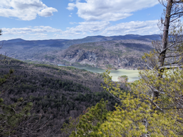
 The South Bay of Lake Champlain seen from The Saddles State Forest | |
| Location | Washington County, New York, United States of America |
| Nearest city | Whitehall |
| Coordinates | 43°31′40″N 73°25′26″W / 43.52778°N 73.42389°W[1] |
| Area | 2,471 acres (10.00 km2)[1] |
| Established | 2013 |
| Governing body | New York State Department of Environmental Conservation |
The Saddles State Forest is a state forest in New York State.[1] The area was purchased by The Nature Conservancy and was sold to the state in 2013.[2] The two peaks that reach 1,600 feet are purportedly the reasoning behind the naming of the forest.[3] The forest contains over 2,250 feet of undeveloped Lake Champlain shoreline.[2] The area is open for recreation year round. A steep unmaintained gravel road from New York State Route 22 provides access to a parking area.[1] There are no marked DEC trails, although unmaintained logging trails and unofficial hiking paths can be found throughout the forest.[3]
Peregrine falcons, bald eagles, and timber rattlesnakes are known to inhabit the area.[1]
References
[edit]- ^ a b c d e "The Saddles State Forest - NYS Dept. of Environmental Conservation". www.dec.ny.gov. New York Department of Environmental Conservation. Retrieved 24 January 2022.
- ^ a b "New York State purchases 3,200 acres in Whitehall". NYVT Media. 1 May 2013. Retrieved 24 January 2022.
- ^ a b Lehman, Don (18 February 2020). "The Saddles State Forest". Glens Falls Post-Star. Retrieved 24 January 2022.

