The Pinnacles (Atherton Tableland)
Appearance
The Pinnacles (Atherton Tableland)[1]
Seven Sisters | |
|---|---|
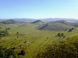
 Aerial view of The Pinnacles, Atherton Tableland, looking to the southwest | |
![The Pinnacles (Atherton Tableland)[1] is located in Queensland](http://upload.wikimedia.org/wikipedia/commons/thumb/7/78/Australia_Queensland_relief_location_map.jpg/250px-Australia_Queensland_relief_location_map.jpg) The Pinnacles (Atherton Tableland)[1] | |
| Coordinates: 17°16′00″S 145°33′00″E / 17.26667°S 145.55000°E |
The Pinnacles (aka the Seven Sisters) are a series of seven volcanic cinder cones on the Atherton Tableland, near Yungaburra, Queensland, Australia. They were formed more than 350,000 years ago.[2]
The vents have an overall southwest-northeast alignment, which suggests that the ascending magma utilised a pre-existing fracture within the Earth's crust.[3] Several of the craters are breached to the southeast, possibly due to the prevailing southeast winds blowing ash and scoria to the northwest and so building the cones more to that side. Parts of the rocky basalt flows are still densely forested and can be seen surrounding the Curtain Fig Tree.
See also
[edit]References
[edit]- ^ "The Pinnacles". Queensland Government Placenames. Queensland Government. Retrieved 12 November 2019.
- ^ Whitehead, P. W.; Stephenson, P. J.; McDougall, I.; Hopkins, M. S.; Graham, A. W.; Collerson, K. D.; Johnson, D. P. (2007). "Temporal development of the Atherton Basalt Province, north Queensland". Australian Journal of Earth Sciences. 54 (5): 691–709. doi:10.1080/08120090701305236. ISSN 0812-0099.
- ^ Rocks, landscapes & resources of the wet tropics. Lottermoser, Bernd G., Willmott, W. F. Brisbane, Qld.: Geological Society of Australia, Queensland Division. 2008. ISBN 9780975789483. OCLC 271828487.
{{cite book}}: CS1 maint: others (link)
External links
[edit]
