Ternitz
Appearance
Ternitz | |
|---|---|
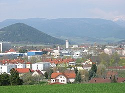
 View of Ternitz | |
| Coordinates: 47°43′N 16°2′E / 47.717°N 16.033°E | |
| Country | Austria |
| State | Lower Austria |
| District | Neunkirchen |
| Government | |
| • Mayor | Rupert Dworak |
| Area | |
• Total | 65.35 km2 (25.23 sq mi) |
| Elevation | 396 m (1,299 ft) |
| Population (2018-01-01)[2] | |
• Total | 14,632 |
| • Density | 220/km2 (580/sq mi) |
| Time zone | UTC+1 (CET) |
| • Summer (DST) | UTC+2 (CEST) |
| Postal code | 2630, 2631 |
| Area code | 02630 |
| Website | http://www.ternitz.at/ |
Ternitz is a town and municipality (14,823 inhabitants end 2014) in the district of Neunkirchen in the Austrian state of Lower Austria, situated at the confluence of the Sierning stream and the River Schwarza, at the western end of the Steinfeld plain. It is divided in the following parts, called Katastralgemeinden: Dunkelstein, Flatz, Holzweg, Mahrersdorf, Pottschach, Putzmannsdorf, Raglitz, Rohrbach am Steinfelde, St. Johann am Steinfelde and Sieding.
History
[edit]
Ternitz's first documented mention was in 1352 and has town status since 1948. It is traditionally known as an industrial town, being home of the Schoeller-Bleckmann company, which was split up into 19 separate companies in 1989.
Population
[edit]| Year | Pop. | ±% |
|---|---|---|
| 1869 | 4,509 | — |
| 1880 | 6,179 | +37.0% |
| 1890 | 7,286 | +17.9% |
| 1900 | 9,263 | +27.1% |
| 1910 | 11,285 | +21.8% |
| 1923 | 12,489 | +10.7% |
| 1934 | 12,775 | +2.3% |
| 1939 | 12,874 | +0.8% |
| 1951 | 14,523 | +12.8% |
| 1961 | 15,569 | +7.2% |
| 1971 | 16,515 | +6.1% |
| 1981 | 16,104 | −2.5% |
| 1991 | 15,443 | −4.1% |
| 2001 | 15,232 | −1.4% |
| 2011 | 14,831 | −2.6% |
References
[edit]- ^ "Dauersiedlungsraum der Gemeinden Politischen Bezirke und Bundesländer - Gebietsstand 1.1.2018". Statistics Austria. Retrieved 10 March 2019.
- ^ "Einwohnerzahl 1.1.2018 nach Gemeinden mit Status, Gebietsstand 1.1.2018". Statistics Austria. Retrieved 9 March 2019.
External links
[edit]Wikimedia Commons has media related to Ternitz.


