Jump to content

Template:Infobox seamount/testcases

Coordinates: 18°16′N 179°20′E / 18.26°N 179.33°E / 18.26; 179.33
From Wikipedia, the free encyclopedia

Loihi Seamount

[edit]
Side by side comparison
{{Infobox seamount}}{{Infobox seamount/sandbox}}
Lōʻihi Seamount
Yellow rocks underwater with a few red and green regions
Yellow iron oxide-covered lava rock on the flank of Lōʻihi
The island of Hawaii, showing Loihi's position southeast of the main landmass.
Southeast of the island of Hawaiʻi
Summit depth975 m (3,199 ft).[1]
Heightover 3,000 m (10,000 ft) above the ocean floor[2]
Translation"long" (from Hawaiian)
Pronunciation[loːˈʔihi]
Location
LocationSoutheast of the island of Hawaiʻi
Coordinates18°55′N 155°16′W / 18.92°N 155.27°W / 18.92; -155.27[1]
CountryHawaiʻi, USA
Geology
TypeSubmarine volcano
Volcanic arc/chainHawaiian–Emperor seamount chain
Age of rockAt least 400,000 years old[3]
Last eruption1996 (active)[4]
History
Discovery date1940 – US Coast and Geodetic Survey chart number 4115[3]
First visit1978[3]

Bowie Seamount

[edit]
Side by side comparison
{{Infobox seamount}}{{Infobox seamount/sandbox}}
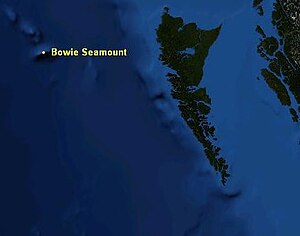
Bowie Seamount
3-D depiction of Bowie Seamount
Map of Bowie Seamount
Summit depth24 m (79 ft)[5][6]
Height~3,000 m (9,843 ft)
Location
LocationNorth Pacific Ocean, 180 km (112 mi) west of the Queen Charlotte Islands
Coordinates53°18′24.93″N 135°39′33.23″W / 53.3069250°N 135.6592306°W / 53.3069250; -135.6592306
CountryCanada
Geology
TypeGuyot
Volcanic arc/chainKodiak–Bowie Seamount chain
Age of rockPleistocene
Last eruption18,000 BP[6]

Allison Guyot

[edit]
Side by side comparison
{{Infobox seamount}}{{Infobox seamount/sandbox}}
Allison Guyot
Allison is located in Pacific Ocean
Allison
Allison
Height1.5 kilometres
Summit area35 x 70 kilometres
Location
GroupMid-Pacific Mountains
Coordinates18°16′N 179°20′E / 18.26°N 179.33°E / 18.26; 179.33[7]
Geology
TypeGuyot
Allison Guyot
Allison is located in Pacific Ocean
Allison
Allison
Height1.5 kilometres
Summit area35 x 70 kilometres
Location
GroupMid-Pacific Mountains
Coordinates18°16′N 179°20′E / 18.26°N 179.33°E / 18.26; 179.33[7]
Geology
TypeGuyot

test automap

[edit]
Side by side comparison
{{Infobox seamount}}{{Infobox seamount/sandbox}}
Allison Guyot
Map
Height1.5 kilometres
Summit area35 x 70 kilometres
Location
GroupMid-Pacific Mountains
Coordinates18°16′N 179°20′E / 18.26°N 179.33°E / 18.26; 179.33[7]
Geology
TypeGuyot
Allison Guyot
Map
Height1.5 kilometres
Summit area35 x 70 kilometres
Location
GroupMid-Pacific Mountains
Coordinates18°16′N 179°20′E / 18.26°N 179.33°E / 18.26; 179.33[7]
Geology
TypeGuyot

References

[edit]
  1. ^ a b "Loihi". Global Volcanism Program. Smithsonian Institution. Retrieved 2009-03-01.
  2. ^ Rubin, Ken (2006-01-19). "General Information About Loihi". Hawaii Center for Volcanology. School of Ocean and Earth Science and Technology. Retrieved 2009-02-01.
  3. ^ a b c Garcia, Michael O.; Jackie Caplan-Auerbach, Eric H. De Carlo, M.D. Kurz, N. Becker (2005-09-20). "Geology, geochemistry and earthquake history of Lōʻihi Seamount, Hawaiʻi" (PDF). This is the author's personal version of a paper that was published on 2006-05-16 as "Geochemistry, and Earthquake History of Lōʻihi Seamount, Hawaiʻi's youngest volcano", in Chemie der Erde - Geochemistry (66) 2:81–108. School of Ocean and Earth Science and Technology. Retrieved 2009-03-20.{{cite web}}: CS1 maint: multiple names: authors list (link)
  4. ^ "Lōʻihi Seamount Hawaiʻi's Youngest Submarine Volcano". Hawaiian Volcano Observatory. United States Geological Survey. Retrieved 2009-03-01.
  5. ^ "Bowie Seamount Marine Protected Area Management Plan" (PDF). Fisheries and Oceans Canada. August 2001. Retrieved October 27, 2008.
  6. ^ a b "The Bowie Seamount Area" (PDF). John F. Dower and Frances J. Fee. February 1999. Retrieved October 27, 2008.
  7. ^ a b Arreguín-Rodríguez, Alegret & Thomas 2016, p. 348.