Jump to content

Template:Infobox mountain/test versus status quo ante 2

From Wikipedia, the free encyclopedia
[edit]

Himalayas

[edit]
Side by side comparison
Status quo anteCurrent infoboxCurrent sandboxSandbox4
Himalayas
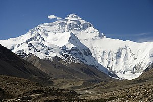
The north face of Mount Everest as seen from the path to the base camp in Tibet Autonomous Region, People's Republic of China.
Highest point
PeakMount Everest
Elevation8,848 m (29,029 ft)
Coordinates27°59′17″N 86°55′31″E / 27.98806°N 86.92528°E / 27.98806; 86.92528
Geography
Countries
List
  • Afghanistan
  • Bhutan
  • Burma
  • People's Republic of China
  • India
  • Nepal
  • Pakistan
Himalayas
The north face of Mount Everest as seen from the path to the base camp in Tibet Autonomous Region, People's Republic of China.
Highest point
PeakMount Everest
Elevation8,848 m (29,029 ft)
Coordinates27°59′17″N 86°55′31″E / 27.98806°N 86.92528°E / 27.98806; 86.92528
Geography
Map
CountriesAfghanistan, Bhutan, Burma, People's Republic of China, India, Nepal and Pakistan
Himalayas
The north face of Mount Everest as seen from the path to the base camp in Tibet Autonomous Region, People's Republic of China.
Highest point
PeakMount Everest
Elevation8,848 m (29,029 ft)
Coordinates27°59′17″N 86°55′31″E / 27.98806°N 86.92528°E / 27.98806; 86.92528
Geography
Countries
List
  • Afghanistan
  • Bhutan
  • Burma
  • People's Republic of China
  • India
  • Nepal
  • Pakistan

Appalachian Mountains

[edit]
Side by side comparison
Status quo anteCurrent infoboxCurrent sandboxSandbox4
Appalachian Mountains
Appalachians
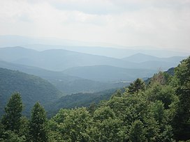
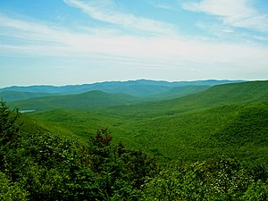
View from the slopes of Back Allegheny Mountain, looking east, in the Appalachian Mountains. Visible are Allegheny Mountain (in the Monongahela National Forest of West Virginia, middle distance) and Shenandoah Mountain (in the George Washington National Forest of Virginia, far distance).
Highest point
PeakMount Mitchell
Elevation6,684 ft (2,037 m)
Geography
CountriesUnited States and Canada
States/Provinces
Geology
OrogenyTaconic
Age of rockOrdovician
Appalachian Mountains
Appalachians
View from the slopes of Back Allegheny Mountain, looking east, in the Appalachian Mountains. Visible are Allegheny Mountain (in the Monongahela National Forest of West Virginia, middle distance) and Shenandoah Mountain (in the George Washington National Forest of Virginia, far distance).
Highest point
PeakMount Mitchell
Elevation6,684 ft (2,037 m)
Geography
CountriesUnited States and Canada
RegionsNewfoundland[1][2], Saint Pierre and Miquelon, Quebec, Nova Scotia, New Brunswick, Maine, New Hampshire, Vermont, Massachusetts, Connecticut, New York, Pennsylvania, Maryland, Virginia, West Virginia, Ohio, Kentucky, Tennessee, New Jersey, North Carolina, South Carolina, Georgia and Alabama
Geology
OrogenyTaconic
Rock ageOrdovician
Appalachian Mountains
Appalachians
View from the slopes of Back Allegheny Mountain, looking east, in the Appalachian Mountains. Visible are Allegheny Mountain (in the Monongahela National Forest of West Virginia, middle distance) and Shenandoah Mountain (in the George Washington National Forest of Virginia, far distance).
Highest point
PeakMount Mitchell
Elevation6,684 ft (2,037 m)
Geography
CountriesUnited States and Canada
States/Provinces
Geology
OrogenyTaconic
Age of rockOrdovician

Alps

[edit]
Side by side comparison
Status quo anteCurrent infoboxCurrent sandboxSandbox4
Alps
Highest point
PeakMont Blanc (Italian: Monte Bianco)
Elevation4,810.45 m (15,782.3 ft)
Coordinates45°50′01″N 06°51′54″E / 45.83361°N 6.86500°E / 45.83361; 6.86500
Geography
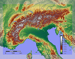
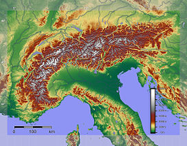
Relief of the Alps. See also map with international borders marked
Countries
List
  • Slovenia
  • France
  • Germany
  • Switzerland
  • Italy
  • Austria
  • Liechtenstein
Geology
OrogenyAlpine orogeny
Age of rockTertiary
Type of rockBündner schist, flysch and molasse
Alps
Highest point
PeakMont Blanc (Italian: Monte Bianco)
Elevation4,810.45 m (15,782.3 ft)
Coordinates45°50′01″N 06°51′54″E / 45.83361°N 6.86500°E / 45.83361; 6.86500
Geography
Relief of the Alps. See also map with international borders marked
CountriesSlovenia, France, Germany, Switzerland, Italy, Austria and Liechtenstein
Geology
OrogenyAlpine orogeny
Rock ageTertiary
Rock typesBündner schist, flysch and molasse
Alps
Highest point
PeakMont Blanc (Italian: Monte Bianco)
Elevation4,810.45 m (15,782.3 ft)
Coordinates45°50′01″N 06°51′54″E / 45.83361°N 6.86500°E / 45.83361; 6.86500
Geography
Relief of the Alps. See also map with international borders marked
Countries
List
  • Slovenia
  • France
  • Germany
  • Switzerland
  • Italy
  • Austria
  • Liechtenstein
Geology
OrogenyAlpine orogeny
Age of rockTertiary
Type of rockBündner schist, flysch and molasse

Andes

[edit]
Side by side comparison
Status quo anteCurrent infoboxCurrent sandboxSandbox4
Andes
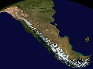
Aerial photo of a portion of the Andes between Argentina and Chile
Highest point
PeakAconcagua (Las Heras Department, Mendoza, Argentina)
Elevation6,962 m (22,841 ft)
Coordinates32°39′10″S 70°0′40″W / 32.65278°S 70.01111°W / -32.65278; -70.01111
Dimensions
Length7,000 km (4,300 mi)
Width500 km (310 mi)
Naming
Native nameError {{native name}}: an IETF language tag as parameter {{{1}}} is required (help)
Geography
Composite satellite image of the southern Andes
Countries
List
  • Argentina
  • Bolivia
  • Chile
  • Colombia
  • Ecuador
  • Peru
  • Venezuela
Settlements
Andes
Aerial photo of a portion of the Andes between Argentina and Chile
Highest point
PeakAconcagua, Las Heras Department, Mendoza, Argentina
Elevation6,962 m (22,841 ft)
Coordinates32°39′10″S 70°0′40″W / 32.65278°S 70.01111°W / -32.65278; -70.01111
Dimensions
Length7,000 km (4,300 mi)
Width500 km (310 mi)
Naming
Native nameAntisuyu Error {{native name checker}}: parameter value is malformed (help)
Geography
Composite satellite image of the southern Andes
CountriesArgentina, Bolivia, Chile, Colombia, Ecuador, Peru and Venezuela
SettlementsBogotá, Santiago, Medellín, La Paz, Cali, Quito, Pasto, Mérida, Arequipa, Mendoza, Cuenca, Cochabamba, Pereira, Ibagué, Salta, Manizales, Cúcuta, Cusco and Bucaramanga
Andes
Aerial photo of a portion of the Andes between Argentina and Chile
Highest point
PeakAconcagua,
Las Heras Department, Mendoza, Argentina
Elevation6,962 m (22,841 ft)
Coordinates32°39′10″S 70°0′40″W / 32.65278°S 70.01111°W / -32.65278; -70.01111
Dimensions
Length7,000 km (4,300 mi)
Width500 km (310 mi)
Naming
Native nameError {{native name}}: an IETF language tag as parameter {{{1}}} is required (help)
Geography
Composite satellite image of the southern Andes
Countries
List
  • Argentina
  • Bolivia
  • Chile
  • Colombia
  • Ecuador
  • Peru
  • Venezuela
Settlements

Sierra Nevada

[edit]
Side by side comparison
Status quo anteCurrent infoboxCurrent sandboxSandbox4
Sierra Nevada
The Sierra's Mills Creek cirque (center) is on the west side of the Sierra Crest, south of Mono Lake (top, blue).
Highest point
PeakMount Whitney
Elevation14,505 ft (4,421 m) [7]
Coordinates36°34′43″N 118°17′31″W / 36.578580925°N 118.291994950°W / 36.578580925; -118.291994950
Dimensions
Length400 mi (640 km) north-south from Fredonyer Pass to Tehachapi Pass[4]
Width65 mi (105 km) [5]
Area24,370 sq mi (63,100 km2) [6]
Naming
Etymology1777: Spanish for "snowy mountain range"
Nicknamethe Sierra, the High Sierra, the Sierras, Range of Light (1894, John Muir)[3]
Geography
Position of Sierra Nevada inside California
CountryUnited States
StatesCalifornia and Nevada
Range coordinates37°44′N 119°34′W / 37.73°N 119.57°W / 37.73; -119.57
Geology
Age of rockMesozoic
Type of rockbatholith and igneous
Sierra Nevada
The Sierra's Mills Creek cirque (center) is on the west side of the Sierra Crest, south of Mono Lake (top, blue).
Highest point
PeakMount Whitney
Elevation14,505 ft (4,421 m)[7]
Coordinates36°34′43″N 118°17′31″W / 36.578580925°N 118.291994950°W / 36.578580925; -118.291994950
Dimensions
Length400 mi (640 km) north-south from Fredonyer Pass to Tehachapi Pass[4]
Width65 mi (105 km)[5]
Area24,370 sq mi (63,100 km2)[6]
Naming
Etymology1777: Spanish for "snowy mountain range"
Nickname(s)the Sierra, the High Sierra, the Sierras, Range of Light (1894, John Muir)[3]
Geography
Position of Sierra Nevada inside California
CountryUnited States
StatesCalifornia and Nevada
Range coordinates37°44′N 119°34′W / 37.73°N 119.57°W / 37.73; -119.57
Geology
Rock ageMesozoic
Rock typesbatholith and igneous
Sierra Nevada
The Sierra's Mills Creek cirque (center) is on the west side of the Sierra Crest, south of Mono Lake (top, blue).
Highest point
PeakMount Whitney
Elevation14,505 ft (4,421 m) [7]
Coordinates36°34′43″N 118°17′31″W / 36.578580925°N 118.291994950°W / 36.578580925; -118.291994950
Dimensions
Length400 mi (640 km) north-south from Fredonyer Pass to Tehachapi Pass [4]
Width65 mi (105 km) [5]
Area24,370 sq mi (63,100 km2) [6]
Naming
Etymology1777: Spanish for "snowy mountain range"
Nicknamethe Sierra, the High Sierra, the Sierras, Range of Light (1894, John Muir)[3]
Geography
Position of Sierra Nevada inside California
CountryUnited States
StatesCalifornia and Nevada
Range coordinates37°44′N 119°34′W / 37.73°N 119.57°W / 37.73; -119.57
Geology
Age of rockMesozoic
Type of rockbatholith and igneous

Catskill Mountains

[edit]
Side by side comparison
Status quo anteCurrent infoboxCurrent sandboxSandbox4
Catskill Mountains
Slide Mountain and the peaks around it as seen from Twin Mountain in the northern Catskills.
Highest point
PeakSlide Mountain (S of Shandaken)
Elevation4,154 ft (1,266 m)
Coordinates41°59′55″N 74°23′11″W / 41.99861°N 74.38639°W / 41.99861; -74.38639
Dimensions
Length111 mi (179 km) N/S
Width102 mi (164 km) E/W
Area15,259 sq mi (39,520 km2)
Geography
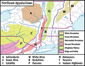
Map of the main regions of the northeast Appalachians, with the Catskills as "C".
CountryUnited States
StateNew York
RegionHudson Valley
Counties
CommunitiesHunter, Tannersville, Monticello and Liberty
Parent rangeAppalachian
Borders onPoconos and Shawangunk Ridge
Geology
Age of rockDevonian and Mississippian
Type of rockSedimentary
Catskill Mountains
Slide Mountain and the peaks around it as seen from Twin Mountain in the northern Catskills.
Highest point
PeakSlide Mountain, S of Shandaken
Elevation4,154 ft (1,266 m)
Coordinates41°59′55″N 74°23′11″W / 41.99861°N 74.38639°W / 41.99861; -74.38639
Dimensions
Length111 mi (179 km) N/S
Width102 mi (164 km) E/W
Area15,259 sq mi (39,520 km2)
Geography
Map of the main regions of the northeast Appalachians, with the Catskills as "C".
CountryUnited States
StateNew York
RegionHudson Valley
CountiesUlster, Greene, Sullivan, Delaware and Schoharie
CommunitiesHunter, Tannersville, Monticello and Liberty
Parent rangeAppalachian
Borders onPoconos and Shawangunk Ridge
Geology
Rock agesDevonian and Mississippian
Rock typeSedimentary
Catskill Mountains
Slide Mountain and the peaks around it as seen from Twin Mountain in the northern Catskills.
Highest point
PeakSlide Mountain,
S of Shandaken
Elevation4,154 ft (1,266 m)
Coordinates41°59′55″N 74°23′11″W / 41.99861°N 74.38639°W / 41.99861; -74.38639
Dimensions
Length111 mi (179 km) N/S
Width102 mi (164 km) E/W
Area15,259 sq mi (39,520 km2) {{{area_note}}}
Geography
Map of the main regions of the northeast Appalachians, with the Catskills as "C".
CountryUnited States
StateNew York
RegionHudson Valley
Counties
CommunitiesHunter, Tannersville, Monticello and Liberty
Parent rangeAppalachian
Borders onPoconos and Shawangunk Ridge
Geology
Age of rockDevonian and Mississippian
Type of rockSedimentary

Unusual range cases

[edit]

map only, dim parameter

[edit]
Side by side comparison
Status quo anteCurrent infoboxCurrent sandboxSandbox4
Rocky Mountains
Rockies
Highest point
PeakMount Elbert (U.S.A.)
Elevation14,440 ft (4,400 m)
Coordinates39°07′03.90″N 106°26′43.29″W / 39.1177500°N 106.4453583°W / 39.1177500; -106.4453583
Dimensions
Length3,000 mi (4,800 km)
Geography
CountriesCanada and United States
States/Provinces
List
  • British Columbia
  • Alberta
  • Idaho
  • Montana
  • Wyoming
  • Utah
  • Colorado
  • New Mexico
Range coordinates43°44′28″N 110°48′09″W / 43.741208°N 110.802414°W / 43.741208; -110.802414
Parent rangeNorth American Cordillera
Geology
Age of rockPrecambrian and Cretaceous
Type of rockIgneous, Sedimentary and Metamorphic
Rocky Mountains
Rockies
Highest point
PeakMount Elbert, U.S.A.
Elevation14,440 ft (4,400 m)
Coordinates39°07′03.90″N 106°26′43.29″W / 39.1177500°N 106.4453583°W / 39.1177500; -106.4453583
Dimensions
Length3,000 mi (4,800 km)
Geography
CountriesCanada and United States
RegionsBritish Columbia, Alberta, Idaho, Montana, Wyoming, Utah, Colorado and New Mexico
Range coordinates43°44′28″N 110°48′09″W / 43.741208°N 110.802414°W / 43.741208; -110.802414
Parent rangeNorth American Cordillera
Geology
Rock agesPrecambrian and Cretaceous
Rock typesIgneous, Sedimentary and Metamorphic
Rocky Mountains
Rockies
Highest point
PeakMount Elbert,
U.S.A.
Elevation14,440 ft (4,400 m)
Coordinates39°07′03.90″N 106°26′43.29″W / 39.1177500°N 106.4453583°W / 39.1177500; -106.4453583
Dimensions
Length3,000 mi (4,800 km)
Geography
CountriesCanada and United States
States/Provinces
List
  • British Columbia
  • Alberta
  • Idaho
  • Montana
  • Wyoming
  • Utah
  • Colorado
  • New Mexico
Range coordinates43°44′28″N 110°48′09″W / 43.741208°N 110.802414°W / 43.741208; -110.802414
Parent rangeNorth American Cordillera
Geology
Age of rockPrecambrian and Cretaceous
Type of rockIgneous, Sedimentary and Metamorphic

Range coordinates

[edit]
Side by side comparison
Status quo anteCurrent infoboxCurrent sandboxSandbox4
Buckskin Mountains (Arizona)
Infobox mountain/test versus status quo ante 2 is located in Arizona
Infobox mountain/test versus status quo ante 2
Buckskin Mountains (Arizona)
in Arizona
Highest point
PeakBattleship Peak
Elevation2,569 ft (783 m)
Coordinates34°04′28″N 113°48′29″W / 34.074467°N 113.808027°W / 34.074467; -113.808027
Dimensions
Length30 mi (48 km) E-W & (SW x NE)
Geography
CountryUnited States
StateArizona
CountyLa Paz
CommunitiesBouse, AZ and Parker Dam, CA
Range coordinates34°10′12.123″N 113°50′46.345″W / 34.17003417°N 113.84620694°W / 34.17003417; -113.84620694
Borders onBill Williams & Rawhide Mountains-N
Bill Williams River-N
Butler ValleyHarcuvar Mountains-SE
Gibralter Mountain Wilderness-W
Buckskin Mountain State Park-W
Alamo Lake State Park-NE
Buckskin Mountains (Arizona)
Buckskin Mountains (Arizona) is located in Arizona
Buckskin Mountains (Arizona)
in Arizona
Highest point
PeakBattleship Peak
Elevation2,569 ft (783 m)
Coordinates34°04′28″N 113°48′29″W / 34.074467°N 113.808027°W / 34.074467; -113.808027
Dimensions
Length30 mi (48 km) E-W & (SW x NE)
Geography
CountryUnited States
StateArizona
CountyLa Paz
CommunitiesBouse, AZ and Parker Dam, CA
Range coordinates34°10′12.123″N 113°50′46.345″W / 34.17003417°N 113.84620694°W / 34.17003417; -113.84620694
Borders onBill Williams & Rawhide Mountains-N
Bill Williams River-N
Butler ValleyHarcuvar Mountains-SE
Gibralter Mountain Wilderness-W
Buckskin Mountain State Park-W
Alamo Lake State Park-NE
Buckskin Mountains (Arizona)
Infobox mountain/test versus status quo ante 2 is located in Arizona
Infobox mountain/test versus status quo ante 2
Buckskin Mountains (Arizona)
in Arizona
Highest point
PeakBattleship Peak
Elevation2,569 ft (783 m)
Coordinates34°04′28″N 113°48′29″W / 34.074467°N 113.808027°W / 34.074467; -113.808027
Dimensions
Length30 mi (48 km) E-W & (SW x NE)
Geography
CountryUnited States
StateArizona
CountyLa Paz
CommunitiesBouse, AZ and Parker Dam, CA
Range coordinates34°10′12.123″N 113°50′46.345″W / 34.17003417°N 113.84620694°W / 34.17003417; -113.84620694
Borders onBill Williams & Rawhide Mountains-N
Bill Williams River-N
Butler ValleyHarcuvar Mountains-SE
Gibralter Mountain Wilderness-W
Buckskin Mountain State Park-W
Alamo Lake State Park-NE

Range coordinates that are difficult to round

[edit]
Side by side comparison
Status quo anteCurrent infoboxCurrent sandboxSandbox4
Black Hills
Infobox mountain/test versus status quo ante 2 is located in California
Infobox mountain/test versus status quo ante 2
location of Black Hills in California [8]
Highest point
Elevation1,158 m (3,799 ft)
Geography
CountryUnited States
StateCalifornia
DistrictSan Bernardino County
Range coordinates35°23′59.873″N 117°18′43.179″W / 35.39996472°N 117.31199417°W / 35.39996472; -117.31199417
Topo mapUSGS Black Hills
Black Hills
Black Hills is located in California
Black Hills
Black Hills
location of Black Hills in California [8]
Highest point
Elevation1,158 m (3,799 ft)
Geography
CountryUnited States
StateCalifornia
DistrictSan Bernardino County
Range coordinates35°23′59.873″N 117°18′43.179″W / 35.39996472°N 117.31199417°W / 35.39996472; -117.31199417
Topo mapUSGS Black Hills
Black Hills
Infobox mountain/test versus status quo ante 2 is located in California
Infobox mountain/test versus status quo ante 2
location of Black Hills in California [8]
Highest point
Elevation1,158 m (3,799 ft)
Geography
CountryUnited States
StateCalifornia
DistrictSan Bernardino County
Range coordinates35°23′59.873″N 117°18′43.179″W / 35.39996472°N 117.31199417°W / 35.39996472; -117.31199417
Topo mapUSGS Black Hills

Range coordinates specified only by degrees

[edit]
Side by side comparison
Status quo anteCurrent infoboxCurrent sandboxSandbox4
Imaginary range
Infobox mountain/test versus status quo ante 2 is located in Nevada
Infobox mountain/test versus status quo ante 2
Highest point
Coordinates37°25′56″N 117°32′10″W / 37.432348°N 117.5362443°W / 37.432348; -117.5362443
Geography
CountryUnited States
StateNevada
Range coordinates37°26′N 117°32′W / 37.43°N 117.54°W / 37.43; -117.54
Imaginary range
Imaginary range is located in Nevada
Imaginary range
Imaginary range
Highest point
Coordinates37°25′56″N 117°32′10″W / 37.432348°N 117.5362443°W / 37.432348; -117.5362443
Geography
CountryUnited States
StateNevada
Range coordinates37°26′N 117°32′W / 37.43°N 117.54°W / 37.43; -117.54
Imaginary range
Imaginary range is located in Nevada
Imaginary range
Imaginary range
Highest point
Coordinates37°25′56″N 117°32′10″W / 37.432348°N 117.5362443°W / 37.432348; -117.5362443
Geography
CountryUnited States
StateNevada
Range coordinates37°26′N 117°32′W / 37.43°N 117.54°W / 37.43; -117.54
Imaginary range
Infobox mountain/test versus status quo ante 2 is located in Nevada
Infobox mountain/test versus status quo ante 2
Highest point
Coordinates37°25′56″N 117°32′10″W / 37.432348°N 117.5362443°W / 37.432348; -117.5362443
Geography
CountryUnited States
StateNevada
Range coordinates37°26′N 117°32′W / 37.43°N 117.54°W / 37.43; -117.54

Country_type + native_name_lang

[edit]
Side by side comparison
Status quo anteCurrent infoboxCurrent sandboxSandbox4
Gagarin Mountains
Infobox mountain/test versus status quo ante 2 is located in Antarctica
Infobox mountain/test versus status quo ante 2
Naming
Native nameKhrebet Yuriya Gagarina (Russian)
Geography
ContinentAntarctica
RegionQueen Maud Land, East Antarctica
Range coordinates71°57′S 09°23′E / 71.950°S 9.383°E / -71.950; 9.383
Parent rangeEast Antarctica Ranges
Gagarin Mountains
Gagarin Mountains is located in Antarctica
Gagarin Mountains
Gagarin Mountains
Naming
Native nameKhrebet Yuriya Gagarina Error {{native name checker}}: parameter value is malformed (help)
Geography
ContinentAntarctica
RegionQueen Maud Land, East Antarctica
Range coordinates71°57′S 09°23′E / 71.950°S 9.383°E / -71.950; 9.383
Parent rangeEast Antarctica Ranges
Gagarin Mountains
Infobox mountain/test versus status quo ante 2 is located in Antarctica
Infobox mountain/test versus status quo ante 2
Naming
Native nameKhrebet Yuriya Gagarina (Russian)
Geography
ContinentAntarctica
RegionQueen Maud Land, East Antarctica
Range coordinates71°57′S 09°23′E / 71.950°S 9.383°E / -71.950; 9.383
Parent rangeEast Antarctica Ranges

Topo map

[edit]
Side by side comparison
Status quo anteCurrent infoboxCurrent sandboxSandbox4
Baldwin Hills
Infobox mountain/test versus status quo ante 2 is located in California
Infobox mountain/test versus status quo ante 2
Location of the Baldwin Hills in California [9]
Highest point
Elevation103 m (338 ft)
Geography
CountryUnited States
StateCalifornia
DistrictLos Angeles County
Range coordinates33°59′43″N 118°21′50″W / 33.99528°N 118.36389°W / 33.99528; -118.36389
Topo mapUSGS Inglewood
Baldwin Hills
Baldwin Hills is located in California
Baldwin Hills
Baldwin Hills
Location of the Baldwin Hills in California [9]
Highest point
Elevation103 m (338 ft)
Geography
CountryUnited States
StateCalifornia
DistrictLos Angeles County
Range coordinates33°59′43″N 118°21′50″W / 33.99528°N 118.36389°W / 33.99528; -118.36389
Topo mapUSGS Inglewood
Baldwin Hills
Infobox mountain/test versus status quo ante 2 is located in California
Infobox mountain/test versus status quo ante 2
Location of the Baldwin Hills in California [9]
Highest point
Elevation103 m (338 ft)
Geography
CountryUnited States
StateCalifornia
DistrictLos Angeles County
Range coordinates33°59′43″N 118°21′50″W / 33.99528°N 118.36389°W / 33.99528; -118.36389
Topo mapUSGS Inglewood

References

[edit]
  1. ^ "International Appalachian Trail- Newfoundland". Iatnl.ca. Retrieved 2010-11-06.
  2. ^ Cees R. van Staal, Mineral Deposits of Canada: Regional Metallogeny: Pre-Carboniferous tectonic evolution and metallogeny of the Canadian Appalachians, Geological Survey of Canada website
  3. ^ Muir, John (1894). "The Sierra Nevada". The Mountains of California. New York: The Century Co. Retrieved 2010-05-29 – via Sierra Club.
  4. ^ "Sierra Nevada". Ecological Subregions of California. United States Forest Service.
  5. ^ "Sierra Nevada". SummitPost.org. Retrieved 2010-05-29.
  6. ^ "The Sierra Nevada Region". USCB Biogeography lab. Archived from the original on 2011-07-20.
  7. ^ "Mount Whitney". NGS Data Sheet. National Geodetic Survey, National Oceanic and Atmospheric Administration, United States Department of Commerce.
  8. ^ "Black Hills". Geographic Names Information System. United States Geological Survey, United States Department of the Interior. Retrieved 2009-05-04.
  9. ^ "Baldwin Hills". Geographic Names Information System. United States Geological Survey, United States Department of the Interior. Retrieved 2009-05-04.