Jump to content

Template:Infobox English county/testcases

Coordinates: 53°10′N 2°35′W / 53.167°N 2.583°W / 53.167; -2.583
From Wikipedia, the free encyclopedia

Surrey ⇒ county council — largest_town

[edit]
Side by side comparison
{{Infobox English county}}{{Infobox English county/sandbox}}
Surrey
Coordinates: 51°15′N 0°25′W / 51.250°N 0.417°W / 51.250; -0.417
Sovereign stateUnited Kingdom
Constituent countryEngland
RegionSouth East
Establishedbefore 1066
Time zoneUTC+0 (GMT)
 • Summer (DST)UTC+1 (BST)
UK ParliamentList of MPs
PoliceSurrey Police
Largest townGuildford
Ceremonial county
Lord LieutenantMichael More-Molyneux
High SheriffDr Julie Llewelyn (2021–22)[1]
Area1,663 km2 (642 sq mi)
 • Rank35th of 48
Population 
(2022)[2]
1,214,540
 • Rank12th of 48
Density731/km2 (1,890/sq mi)
Non-metropolitan county
County councilSurrey County Council
ControlConservative
Admin HQReigate
Area1,663 km2 (642 sq mi)
 • Rank20th of 21
Population 
(2022)[3]
1,214,540
 • Rank5th of 21
Density731/km2 (1,890/sq mi)
ISO 3166-2GB-SRY
GSS codeE10000030
ITLUKJ23
Websitewww.surreycc.gov.uk
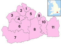
Districts

Districts of Surrey
Districts
  1. Spelthorne
  2. Runnymede
  3. Surrey Heath
  4. Woking
  5. Elmbridge
  6. Guildford
  7. Waverley
  8. Mole Valley
  9. Epsom and Ewell
  10. Reigate and Banstead
  11. Tandridge
Surrey
Coordinates: 51°15′N 0°25′W / 51.250°N 0.417°W / 51.250; -0.417
Sovereign stateUnited Kingdom
Constituent countryEngland
RegionSouth East
Establishedbefore 1066
Time zoneUTC±00:00 (Greenwich Mean Time)
 • Summer (DST)UTC+01:00 (British Summer Time)
Members of ParliamentList of MPs
PoliceSurrey Police
Largest townGuildford
Ceremonial county
Lord LieutenantMichael More-Molyneux
High SheriffDr Julie Llewelyn (2021–22)[1]
Area1,663 km2 (642 sq mi)
 • Ranked35th of 48
Population (2022)1,214,540
 • Ranked12th of 48
Density731/km2 (1,890/sq mi)
Non-metropolitan county
County councilSurrey County Council
Executive 
Admin HQReigate
Area1,663 km2 (642 sq mi)
 • Ranked of 26
 • Ranked of 26
Density[convert: needs a number]
ISO 3166-2GB-SRY
ONS code43
GSS codeE10000030
ITLUKJ23
Websitewww.surreycc.gov.uk
Districts

Districts of Surrey
Districts
  1. Spelthorne
  2. Runnymede
  3. Surrey Heath
  4. Woking
  5. Elmbridge
  6. Guildford
  7. Waverley
  8. Mole Valley
  9. Epsom and Ewell
  10. Reigate and Banstead
  11. Tandridge

Northumberland ⇒ unitary council — largest_town

[edit]
Side by side comparison
{{Infobox English county}}{{Infobox English county/sandbox}}
Northumberland
Coordinates: 55°10′N 2°00′W / 55.167°N 2.000°W / 55.167; -2.000
Sovereign stateUnited Kingdom
Constituent countryEngland
RegionNorth East
EstablishedAncient
12th century
Time zoneUTC+0 (GMT)
 • Summer (DST)UTC+1 (BST)
UK ParliamentList of MPs
PoliceNorthumbria Police
Largest townBlyth
Ceremonial county
Lord LieutenantJane Percy, Duchess of Northumberland
High SheriffThomas Fairfax of Mindrum [4] (2020–21)
Area5,020 km2 (1,940 sq mi)
 • Rank6th of 48
Population 
(2022)[5]
324,362
 • Rank44th of 48
Density65/km2 (170/sq mi)
Ethnicity
95.4% White British
Unitary authority
CouncilNorthumberland County Council
ControlNo overall control
Admin HQMorpeth
Area5,020 km2 (1,940 sq mi)
 • Rank2nd of 296
Population 
(2022)[6]
324,362
 • Rank39th of 296
Density65/km2 (170/sq mi)
ISO 3166-2GB-NBL
GSS codeE06000057
ITLUKC21
WebsiteUnitary authority council
Northumberland
Coordinates: 55°10′N 2°00′W / 55.167°N 2.000°W / 55.167; -2.000
Sovereign stateUnited Kingdom
Constituent countryEngland
RegionNorth East
EstablishedAncient
12th century
Time zoneUTC±00:00 (Greenwich Mean Time)
 • Summer (DST)UTC+01:00 (British Summer Time)
Members of ParliamentList of MPs
PoliceNorthumbria Police
Largest townBlyth
Ceremonial county
Lord LieutenantJane Percy, Duchess of Northumberland
High SheriffThomas Fairfax of Mindrum [4] (2020–21)
Area5,013 km2 (1,936 sq mi)
 • Ranked6th of 48
Population (2022)324,362
 • Ranked44th of 48
Density65/km2 (170/sq mi)
Ethnicity95.4% White British
Unitary authority
CouncilNorthumberland County Council
ExecutiveNo overall control
Admin HQMorpeth
Area5,020 km2 (1,940 sq mi)
 • Ranked2nd of 326
Population324,362
 • Ranked39th of 326
Density65/km2 (170/sq mi)
ISO 3166-2GB-NBL
ONS code00EM
GSS codeE06000057
ITLUKC21
WebsiteUnitary authority council

West Midlands ◇ — largest_city

[edit]
Side by side comparison
{{Infobox English county}}{{Infobox English county/sandbox}}
West Midlands
West Midlands within England
Sovereign stateUnited Kingdom
Constituent countryEngland
RegionWest Midlands
Established1 April 1974
Established byLocal Government Act 1972
Time zoneUTC+0 (GMT)
 • Summer (DST)UTC+1 (BST)
UK Parliament
  • 14 Conservative
  • 14 Labour
List of MPs
PoliceWest Midlands Police
Largest cityBirmingham
Ceremonial county
Lord LieutenantJohn Crabtree, OBE
High SheriffWade Lyn, CBE[7] (2020–21)
Area902 km2 (348 sq mi)
 • Rank42nd of 48
Population 
(2022)[9]
2,953,816
 • Rank2nd of 48
Density3,276/km2 (8,480/sq mi)
Ethnicity
70.1% White (69.0% White British)
18.9% Asian
6.0% Black
3.4% Mixed
1.6% Other[8]
Metropolitan county
GovernmentWest Midlands Combined Authority
Mayor Andy Street (C)
Admin HQBirmingham
Area902 km2 (348 sq mi)
ITLUKG3
Websitewww.wmca.org.uk
Districts

Districts of West Midlands
Districts
  1. City of Wolverhampton
  2. Dudley
  3. Walsall
  4. Sandwell
  5. City of Birmingham
  6. Solihull
  7. City of Coventry
West Midlands
West Midlands within England
Sovereign stateUnited Kingdom
Constituent countryEngland
RegionWest Midlands
Established1 April 1974
Established byLocal Government Act 1972
Time zoneUTC±00:00 (Greenwich Mean Time)
 • Summer (DST)UTC+01:00 (British Summer Time)
Members of Parliament
  • 14 Conservative
  • 14 Labour
List of MPs
PoliceWest Midlands Police
Largest cityBirmingham
Ceremonial county
Lord LieutenantJohn Crabtree, OBE
High SheriffWade Lyn, CBE[7] (2020–21)
Area902 km2 (348 sq mi)
 • Ranked42nd of 48
Population (2022)2,953,816
 • Ranked2nd of 48
Density3,276/km2 (8,480/sq mi)
Ethnicity70.1% White (69.0% White British)
18.9% Asian
6.0% Black
3.4% Mixed
1.6% Other[8]
Metropolitan county
GovernmentWest Midlands Combined Authority
Mayor Andy Street (C)
Admin HQBirmingham
Area902 km2 (348 sq mi)
ONS code2E
ITLUKG3
Websitewww.wmca.org.uk
Districts

Districts of West Midlands
Districts
  1. City of Wolverhampton
  2. Dudley
  3. Walsall
  4. Sandwell
  5. City of Birmingham
  6. Solihull
  7. City of Coventry

Greater Manchester ◇

[edit]
Side by side comparison
{{Infobox English county}}{{Infobox English county/sandbox}}
Greater Manchester
Coordinates: 53°30′N 2°19′W / 53.500°N 2.317°W / 53.500; -2.317
Sovereign stateUnited Kingdom
Constituent countryEngland
RegionNorth West
Established1 April 1974
Established byLocal Government Act 1972
Time zoneUTC+0 (GMT)
 • Summer (DST)UTC+1 (BST)
UK Parliament
  • 18 Labour
  • 9 Conservative
List of MPs
PoliceGreater Manchester Police
Ceremonial county
Lord LieutenantSir Warren James Smith
High SheriffEamonn O'Neal[10] (2020–21)
Area1,276 km2 (493 sq mi)
 • Rank39th of 48
Population 
(2022)[11]
2,911,744
 • Rank3rd of 48
Density2,282/km2 (5,910/sq mi)
Metropolitan county
Government• Type
Combined authority
• Body
Greater Manchester Combined Authority
Mayor
Andy Burnham (L)
GSS codeE11000001
ITLUKD3
Websitewww.greatermanchester-ca.gov.uk
Districts

Districts of Greater Manchester
Metropolitan districts
Districts
  1. City of Manchester
  2. Stockport
  3. Tameside
  4. Oldham
  5. Rochdale
  6. Bury
  7. Bolton
  8. Wigan
  9. City of Salford
  10. Trafford
Greater Manchester
Coordinates: 53°30′N 2°19′W / 53.500°N 2.317°W / 53.500; -2.317
Sovereign stateUnited Kingdom
Constituent countryEngland
RegionNorth West
Established1 April 1974
Established byLocal Government Act 1972
Time zoneUTC±00:00 (Greenwich Mean Time)
 • Summer (DST)UTC+01:00 (British Summer Time)
Members of Parliament
  • 18 Labour
  • 9 Conservative
List of MPs
PoliceGreater Manchester Police
Ceremonial county
Lord LieutenantSir Warren James Smith
High SheriffEamonn O'Neal[10] (2020–21)
Area1,276 km2 (493 sq mi)
 • Ranked39th of 48
Population (2022)2,911,744
 • Ranked3rd of 48
Density2,282/km2 (5,910/sq mi)
Metropolitan county
Government• Type
Combined authority
• Body
Greater Manchester Combined Authority
Mayor
Andy Burnham (L)
ONS code2A
GSS codeE11000001
ITLUKD3
Websitewww.greatermanchester-ca.gov.uk
Districts

Districts of Greater Manchester
Metropolitan districts
Districts
  1. City of Manchester
  2. Stockport
  3. Tameside
  4. Oldham
  5. Rochdale
  6. Bury
  7. Bolton
  8. Wigan
  9. City of Salford
  10. Trafford

Buckinghamshire ◎ — largest_city

[edit]
Side by side comparison
{{Infobox English county}}{{Infobox English county/sandbox}}
Buckinghamshire
Motto(s)
Vestigia nulla retrorsum
("No turning back / We do not retreat")
Coordinates: 51°50′N 0°50′W / 51.833°N 0.833°W / 51.833; -0.833
Sovereign stateUnited Kingdom
Constituent countryEngland
RegionSouth East
EstablishedAncient
Time zoneUTC+0 (GMT)
 • Summer (DST)UTC+1 (BST)
UK Parliament7 MPs
PoliceThames Valley Police
Largest cityMilton Keynes
Ceremonial county
Lord LieutenantThe Countess Howe DL
from 26 June 2020
High SheriffGeorge Rupert Anson[12] (2021–22)
Area1,874 km2 (724 sq mi)
 • Rank32nd of 48
Population 
(2022)[13]
852,589
 • Rank29th of 48
Density455/km2 (1,180/sq mi)
Ethnicity
91.7% White
4.3% S. Asian
1.6% Black[citation needed]
Districts

Districts of Buckinghamshire
Unitary
Districts
  1. Buckinghamshire
  2. Milton Keynes
Buckinghamshire
Motto(s)
Vestigia nulla retrorsum
("No turning back / We do not retreat")
Coordinates: 51°50′N 0°50′W / 51.833°N 0.833°W / 51.833; -0.833
Sovereign stateUnited Kingdom
Constituent countryEngland
RegionSouth East
EstablishedAncient
Time zoneUTC±00:00 (Greenwich Mean Time)
 • Summer (DST)UTC+01:00 (British Summer Time)
Members of Parliament7 MPs
PoliceThames Valley Police
Largest cityMilton Keynes
Ceremonial county
Lord LieutenantThe Countess Howe DL
from 26 June 2020
High SheriffGeorge Rupert Anson[12] (2021–22)
Area1,874 km2 (724 sq mi)
 • Ranked32nd of 48
Population (2022)852,589
 • Ranked29th of 48
Density455/km2 (1,180/sq mi)
Ethnicity91.7% White
4.3% S. Asian
1.6% Black[citation needed]
Districts

Districts of Buckinghamshire
Unitary
Districts
  1. Buckinghamshire
  2. Milton Keynes

Wiltshire ⇒ unitary council — largest_city and largest_town

[edit]
Side by side comparison
{{Infobox English county}}{{Infobox English county/sandbox}}
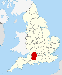
Wiltshire
Wiltshire within England
Coordinates: 51°20′N 1°55′W / 51.333°N 1.917°W / 51.333; -1.917
Sovereign stateUnited Kingdom
Constituent countryEngland
RegionSouth West
EstablishedAncient
Time zoneUTC+0 (GMT)
 • Summer (DST)UTC+1 (BST)
UK ParliamentList of MPs
PoliceWiltshire Police
Largest cityLargecity
Ceremonial county
Lord LieutenantSarah Troughton
High Sheriff> Sir Charles Hobhouse (2021–2022)[14]
Area3,485 km2 (1,346 sq mi)
 • Rank14th of 48
Population 
(2022)[15]
751,542
 • Rank34th of 48
Density216/km2 (560/sq mi)
Ethnicity
2011 Census, excluding Swindon: 93.4% White British
1.3% Asian
1.2% Mixed Race
0.6% Black
0.2% Other
Unitary authority
CouncilWiltshire Council
ControlConservative
Admin HQTrowbridge
Area3,255 km2 (1,257 sq mi)
 • Rank6th of 296
Population 
(2022)[16]
515,885
 • Rank11th of 296
Density158/km2 (410/sq mi)
ISO 3166-2GB-WIL
GSS codeE06000054
ITLUKK15
Websitewww.wiltshire.gov.uk
www.swindon.gov.uk
Districts

Districts of Wiltshire
Unitary
Districts
  1. Wiltshire
  2. Swindon
Wiltshire
Wiltshire within England
Coordinates: 51°20′N 1°55′W / 51.333°N 1.917°W / 51.333; -1.917
Sovereign stateUnited Kingdom
Constituent countryEngland
RegionSouth West
EstablishedAncient
Time zoneUTC±00:00 (Greenwich Mean Time)
 • Summer (DST)UTC+01:00 (British Summer Time)
Members of ParliamentList of MPs
PoliceWiltshire Police
Largest cityLargecity
Ceremonial county
Lord LieutenantSarah Troughton
High Sheriff> Sir Charles Hobhouse (2021–2022)[14]
Area3,485 km2 (1,346 sq mi)
 • Ranked14th of 48
Population (2022)751,542
 • Ranked34th of 48
Density216/km2 (560/sq mi)
Ethnicity2011 Census, excluding Swindon: 93.4% White British
1.3% Asian
1.2% Mixed Race
0.6% Black
0.2% Other
Unitary authority
CouncilWiltshire Council
ExecutiveConservative
Admin HQTrowbridge
Area3,255 km2 (1,257 sq mi)
 • Ranked6th of 326
Population515,885
 • Ranked11th of 326
Density158/km2 (410/sq mi)
ISO 3166-2GB-WIL
ONS code00HY
GSS codeE06000054
ITLUKK15
Websitewww.wiltshire.gov.uk
www.swindon.gov.uk
Districts

Districts of Wiltshire
Unitary
Districts
  1. Wiltshire
  2. Swindon

Cheshire ◎ — largest_town

[edit]
Side by side comparison
{{Infobox English county}}{{Infobox English county/sandbox}}
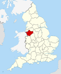
Cheshire
County Palatine of Chester
Motto(s)
Jure Et Dignitate Gladii
("By the right and dignity of the sword")
Coordinates: 53°10′N 2°35′W / 53.167°N 2.583°W / 53.167; -2.583
Sovereign stateUnited Kingdom
Constituent countryEngland
RegionNorth West
EstablishedAncient
Time zoneUTC+0 (GMT)
 • Summer (DST)UTC+1 (BST)
UK ParliamentList of MPs
PoliceCheshire Constabulary
Largest townWarrington
Ceremonial county
Lord LieutenantThomas David Briggs
High SheriffNicholas Hopkinson
(2020–21)[17]
Area2,346 km2 (906 sq mi)
 • Rank25th of 48
Population 
(2022)[18]
1,108,765
 • Rank18th of 48
Density473/km2 (1,230/sq mi)
Ethnicity
97.3% White
1.7% Asian
0.6% Black
0.4% White Other
Districts

Districts of Cheshire
All unitary
Districts
  1. Cheshire West and Chester
  2. Cheshire East
  3. Warrington
  4. Halton
Cheshire
County Palatine of Chester
Motto(s)
Jure Et Dignitate Gladii
("By the right and dignity of the sword")
Coordinates: 53°10′N 2°35′W / 53.167°N 2.583°W / 53.167; -2.583
Sovereign stateUnited Kingdom
Constituent countryEngland
RegionNorth West
EstablishedAncient
Time zoneUTC±00:00 (Greenwich Mean Time)
 • Summer (DST)UTC+01:00 (British Summer Time)
Members of ParliamentList of MPs
PoliceCheshire Constabulary
Largest townWarrington
Ceremonial county
Lord LieutenantThomas David Briggs
High SheriffNicholas Hopkinson
(2020–21)[17]
Area2,343 km2 (905 sq mi)
 • Ranked25th of 48
Population (2022)1,108,765
 • Ranked18th of 48
Density473/km2 (1,230/sq mi)
Ethnicity97.3% White
1.7% Asian
0.6% Black
0.4% White Other
Districts

Districts of Cheshire
All unitary
Districts
  1. Cheshire West and Chester
  2. Cheshire East
  3. Warrington
  4. Halton

Greater London ◇

[edit]
Side by side comparison
{{Infobox English county}}{{Infobox English county/sandbox}}
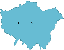
Greater London
London region
Greater London ceremonial county (red)
City of London (red & white stripes)
Greater London administrative area (= London region) (both)
Sovereign stateUnited Kingdom
Constituent countryEngland
Established1 April 1965
Established byLondon Government Act 1963
Time zoneUTC+0 (GMT)
 • Summer (DST)UTC+1 (BST)
UK Parliament73 MPs
PoliceCity of London Police and Metropolitan Police
Ceremonial county
Lord LieutenantKen Olisa
High SheriffJohn Garbutt[20] (2020–21)
Area1,569 km2 (606 sq mi)
 • Rank37th of 48
Population 
(2022)[23]
8,855,333
 • Rank1st of 48
Density5,643/km2 (14,620/sq mi)
Ethnicity
59.8% White (of which 44.9% White British)
18.4% Asian
13.3% Black
5% mixed
3.4% other
Region
GovernmentGreater London Authority
Mayor Sadiq Khan
London Assembly
Admin HQNewham[19]
Area1,572 km2 (607 sq mi)
Population
8,961,989 (mid-2019 estimate)[21]
Density5,701/km2 (14,770/sq mi)
GSS codeE12000007
ITLUKI
Websitelondon.gov.uk
Counties of the London region
Counties
  1. City of London
  2. Greater London
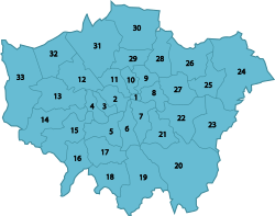
Districts
Boroughs of London
Districts of Greater London
Districts
Greater London
London region
Greater London ceremonial county (red)
City of London (red & white stripes)
Greater London administrative area (= London region) (both)
Sovereign stateUnited Kingdom
Constituent countryEngland
Established1 April 1965
Established byLondon Government Act 1963
Time zoneUTC±00:00 (Greenwich Mean Time)
 • Summer (DST)UTC+01:00 (British Summer Time)
Members of Parliament73 MPs
PoliceCity of London Police and Metropolitan Police
Ceremonial county
Lord LieutenantKen Olisa
High SheriffJohn Garbutt[20] (2020–21)
Area1,569 km2 (606 sq mi)
 • Ranked25th of 48
Population (2022)8,855,333
 • Ranked1st of 48
Density5,643/km2 (14,620/sq mi)
Ethnicity59.8% White (of which 44.9% White British)
18.4% Asian
13.3% Black
5% mixed
3.4% other
Region
GovernmentGreater London Authority
Mayor Sadiq Khan
London Assembly
Admin HQNewham[19]
Area1,572 km2 (607 sq mi)
Population8,961,989 (mid-2019 estimate)[21]
Density5,701/km2 (14,770/sq mi)
ONS codeH
GSS codeE12000007
ITLUKI
Websitelondon.gov.uk
Counties of the London region
Counties
  1. City of London
  2. Greater London
Districts
Boroughs of London
Districts of Greater London
Districts
  1. ^ "Home - High Sheriff of Surrey". Retrieved 5 January 2022.
  2. ^ "Mid-2022 population estimates by Lieutenancy areas (as at 1997) for England and Wales". Office for National Statistics. 24 June 2024. Retrieved 26 June 2024.
  3. ^ "Mid-Year Population Estimates, UK, June 2022". Office for National Statistics. 26 March 2024. Retrieved 3 May 2024.
  4. ^ "No. 62943". The London Gazette. 13 March 2020. p. 5161.
  5. ^ "Mid-2022 population estimates by Lieutenancy areas (as at 1997) for England and Wales". Office for National Statistics. 24 June 2024. Retrieved 26 June 2024.
  6. ^ "Mid-Year Population Estimates, UK, June 2022". Office for National Statistics. 26 March 2024. Retrieved 3 May 2024.
  7. ^ "No. 62943". The London Gazette. 13 March 2020. p. 5161.
  8. ^ "2011 Census: Key Statistics for Local Authorities in England and Wales". ONS. Archived from the original on 24 February 2016. Retrieved 26 December 2012.
  9. ^ "Mid-2022 population estimates by Lieutenancy areas (as at 1997) for England and Wales". Office for National Statistics. 24 June 2024. Retrieved 26 June 2024.
  10. ^ "Former MEN and Granada exec named High Sheriff of Greater Manchester". Prolificnorth. 12 March 2020. Retrieved 12 April 2020.
  11. ^ "Mid-2022 population estimates by Lieutenancy areas (as at 1997) for England and Wales". Office for National Statistics. 24 June 2024. Retrieved 26 June 2024.
  12. ^ "No. 63290". The London Gazette. 11 March 2021. p. 4778.
  13. ^ "Mid-2022 population estimates by Lieutenancy areas (as at 1997) for England and Wales". Office for National Statistics. 24 June 2024. Retrieved 26 June 2024.
  14. ^ "No. 63290". The London Gazette. 11 March 2021. p. 4778.
  15. ^ "Mid-2022 population estimates by Lieutenancy areas (as at 1997) for England and Wales". Office for National Statistics. 24 June 2024. Retrieved 26 June 2024.
  16. ^ "Mid-Year Population Estimates, UK, June 2022". Office for National Statistics. 26 March 2024. Retrieved 3 May 2024.
  17. ^ "No. 62943". The London Gazette. 13 March 2020. p. 5161.
  18. ^ "Mid-2022 population estimates by Lieutenancy areas (as at 1997) for England and Wales". Office for National Statistics. 24 June 2024. Retrieved 26 June 2024.
  19. ^ "'London is moving east': City Hall's Crystal move confirmed for New Year". 30 November 2021.
  20. ^ "No. 62943". The London Gazette. 13 March 2020. p. 5161.
  21. ^ "MYE2: Population Estimates by single year of age and sex for local authorities in the UK, mid-2019". ONS. Office for National Statistics. Retrieved 15 July 2020.
  22. ^ "Sub-national HDI - Area Database - Global Data Lab". hdi.globaldatalab.org. Retrieved 2020-07-15.
  23. ^ "Mid-2022 population estimates by Lieutenancy areas (as at 1997) for England and Wales". Office for National Statistics. 24 June 2024. Retrieved 26 June 2024.