Temnine Et Tahta
Appearance
Temnine Et Tahta
تمنين التحتا | |
|---|---|
Village | |
| Coordinates: 33°53′01″N 35°59′29″E / 33.88361°N 35.99139°E | |
| Country | |
| Governorate | Baalbek-Hermel Governorate |
| District | Baalbek District |
| Elevation | 3,150 ft (960 m) |
| Time zone | UTC+2 (EET) |
| • Summer (DST) | +3 |
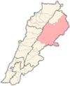
Temnine Et Tahta (Arabic: تمنين التحتا) is a village located in the Baalbek District of the Baalbek-Hermel Governorate in Lebanon.
History
[edit]In 1838, Eli Smith noted Temnin the lower's population as being predominantly Metawileh.[1]
References
[edit]Bibliography
[edit]External links
[edit]- Temnine Et Tahta, localiban


