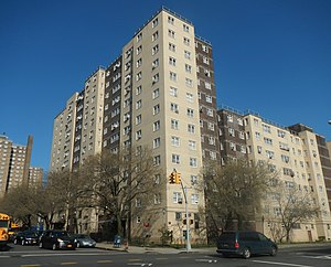
Taylor–Wythe Houses
Appearance
(Redirected from Taylor/Wythe Houses)
Taylor–Wythe Houses | |
|---|---|
 | |
 Location within New York City | |
| Coordinates: 40°42′16″N 73°57′54″W / 40.704570°N 73.964960°W | |
| Country | |
| State | |
| City | New York City |
| Borough | Brooklyn |
| ZIP codes | 11211 |
| Area code(s) | 718, 347, 929, and 917 |
The Taylor–Wythe Houses is a New York City Housing Authority development in the Williamsburg neighborhood, in Brooklyn, New York City.
Development
[edit]The Taylor–Wythe Houses were completed June 30, 1974 and consists of five buildings, 8, 11, 12 and 13 stories high on 4.2 acres (17,000 m2). There are 525 apartments housing some 1,681 residents. The development is bounded by Wythe Ave, Ross Street, and Clymer Street. The B44, B62, 67 buses and the J, M, and Z trains subway routes service the area. The neighborhood is a mix of Hispanic, African-American, and Hasidic families, with gentrification as an ongoing process that is transforming the landscape.
