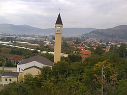
Tasovčići
Appearance
Tasovčići | |
|---|---|
 View of Tasovčići with St. John the Baptist Roman Catholic church | |
| Coordinates: 43°06′48″N 17°43′12″E / 43.11333°N 17.72000°E | |
| Country | |
| Entity | Federation of Bosnia and Herzegovina |
| Canton | |
| Municipality | |
| Area | |
• Total | 3.10 sq mi (8.02 km2) |
| Population (2013) | |
• Total | 1,950 |
| • Density | 630/sq mi (240/km2) |
| Time zone | UTC+1 (CET) |
| • Summer (DST) | UTC+2 (CEST) |
Tasovčići is a village in Bosnia and Herzegovina. According to the 1991 census, the village is located in the municipality of Čapljina.[1]
History
[edit]In the Roman period, there was a settlement called Latin: Ad Turres[2] here. Originally belonging to the Manii tribe, it was on the road from Narona (modern Vid, Croatia) to Diluntum (modern Stolac, Bosnia and Hercegovina).
Demographics
[edit]According to the 2013 census, its population was 1,950.[3]
| Ethnicity | Number | Percentage |
|---|---|---|
| Croats | 1,555 | 79.7% |
| Bosniaks | 241 | 12.4% |
| Serbs | 129 | 6.6% |
| other/undeclared | 25 | 1.3% |
| Total | 1,950 | 100% |
References
[edit]- ^ Official results from the book: Ethnic composition of Bosnia-Herzegovina population, by municipalities and settlements, 1991. census, Zavod za statistiku Bosne i Hercegovine - Bilten no.234, Sarajevo 1991.
- ^ Richard Talbert, Barrington Atlas of the Greek and Roman World, (ISBN 0-691-03169-X), Map 20, notes.
- ^ "Naseljena Mjesta 1991/2013" (in Bosnian). Statistical Office of Bosnia and Herzegovina. Retrieved September 27, 2021.
External links
[edit]- Hazlitt's Classical Gazetteer
- Čapljina portal umrli
- Geographic Names Information System, for coordinates
43°06′48″N 17°43′12″E / 43.11333°N 17.72000°E
Wikimedia Commons has media related to Tasovčići.

