Talaskara Ridge


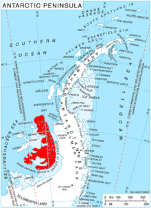
Talaskara Ridge (Bulgarian: рид Таласкара, ‘Rid Talaskara’ \'rid ta-la-'ska-ra\) is the ice-covered ridge extending 7.5 km in southeast–northwest direction and 1.8 km wide, rising to 1122 m (central height) and 1201 m (south height)[1] on the northwest side of Rouen Mountains in northern Alexander Island, Antarctica. It surmounts Bongrain Ice Piedmont to the west and southwest. The vicinity was visited on 6 January 1988 by the geological survey party of Christo Pimpirev and Borislav Kamenov (First Bulgarian Antarctic Expedition), and Philip Nell and Peter Marquis (British Antarctic Survey).
The feature is named after the ancient Thracian fortress of Talaskara in Southeastern Bulgaria.
Location
[edit]The ridge's central height is located at 68°56′21.5″S 71°04′53″W / 68.939306°S 71.08139°W, which is 30.9 km southwest of the island's northeast extremity Cape Arauco, 5.77 km west-southwest of Mount Bayonne and 9.4 km northwest of Mount Paris, and 29.95 km northeast of Mount Newman in Havre Mountains.
Maps
[edit]- British Antarctic Territory. Scale 1:250000 topographic map. Sheet SR19-20/5. APC UK, 1991
- Antarctic Digital Database (ADD). Scale 1:250000 topographic map of Antarctica. Scientific Committee on Antarctic Research (SCAR). Since 1993, regularly upgraded and updated
Notes
[edit]- ^ Reference Elevation Model of Antarctica. Polar Geospatial Center. University of Minnesota, 2019
References
[edit]- Bulgarian Antarctic Gazetteer. Antarctic Place-names Commission. (details in Bulgarian, basic data in English)
- Talaskara Ridge. SCAR Composite Gazetteer of Antarctica
External links
[edit]- Talaskara Ridge. Copernix satellite image
This article includes information from the Antarctic Place-names Commission of Bulgaria which is used with permission.
