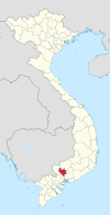
Tân Đông Hiệp
Appearance
You can help expand this article with text translated from the corresponding article in Vietnamese. (March 2015) Click [show] for important translation instructions.
|
Tân Đông Hiệp
Phường Tân Đông Hiệp | |
|---|---|
Ward | |
 | |
| Coordinates: 10°55′06.3″N 106°46′08.5″E / 10.918417°N 106.769028°E | |
| Country | |
| Region | Southeast |
| Province | Bình Dương |
| Town | Dĩ An |
| Area | |
| • Total | 4.60 sq mi (11.92 km2) |
| Population (2018)[1] | |
| • Total | 89,090 |
| • Density | 19,000/sq mi (7,500/km2) |
| Time zone | UTC+7 (UTC + 7) |
Tân Đông Hiệp is a ward of Dĩ An town in Bình Dương Province of Southeast region of Vietnam.

