Suksun
Suksun
Суксун | |
|---|---|
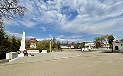
 Main square and war memorial, Suksun | |
| Coordinates: 57°09′N 57°23′E / 57.150°N 57.383°E | |
| Country | Russia |
| Federal subject | Perm Krai |
| Administrative district | Suksunsky District |
| Founded | 1651 |
| Population | |
• Total | 8,022 |
| Time zone | UTC+5 (MSK+2 |
| Postal code(s)[3] | |
| OKTMO ID | 57731000051 |
Suksun (Russian: Суксун) is an urban locality (a work settlement) and the administrative center of Suksunsky District of Perm Krai, Russia, located on the left bank of the Sylva River (a tributary of the Chusovaya River), 150 kilometers (93 mi) from the city of Perm. Population: 8,022 (2010 Census);[1] 8,495 (2002 Census);[4] 8,882 (1989 Soviet census).[5]
Etymology
[edit]The name is of Turkic origin and means cold water.[6]
History
[edit]Suksun was first mentioned as a settlement in 1651.[7] The town grew around the copper smelting and iron works plant built by Akinfiy Demidov in 1727–1729.[6] Urban-type settlement status was granted to it on June 20, 1933.[6]
In the mid 18th century, due to the presence of copper, the town became known for the production of copper utensils and Samovars. While copper is no longer mined in Suksun, Samovars are still being manufactured there.
References
[edit]- ^ a b Russian Federal State Statistics Service (2011). Всероссийская перепись населения 2010 года. Том 1 [2010 All-Russian Population Census, vol. 1]. Всероссийская перепись населения 2010 года [2010 All-Russia Population Census] (in Russian). Federal State Statistics Service.
- ^ "Об исчислении времени". Официальный интернет-портал правовой информации (in Russian). June 3, 2011. Retrieved January 19, 2019.
- ^ Почта России. Информационно-вычислительный центр ОАСУ РПО. (Russian Post). Поиск объектов почтовой связи (Postal Objects Search) (in Russian)
- ^ Federal State Statistics Service (May 21, 2004). Численность населения России, субъектов Российской Федерации в составе федеральных округов, районов, городских поселений, сельских населённых пунктов – районных центров и сельских населённых пунктов с населением 3 тысячи и более человек [Population of Russia, Its Federal Districts, Federal Subjects, Districts, Urban Localities, Rural Localities—Administrative Centers, and Rural Localities with Population of Over 3,000] (XLS). Всероссийская перепись населения 2002 года [All-Russia Population Census of 2002] (in Russian).
- ^ Всесоюзная перепись населения 1989 г. Численность наличного населения союзных и автономных республик, автономных областей и округов, краёв, областей, районов, городских поселений и сёл-райцентров [All Union Population Census of 1989: Present Population of Union and Autonomous Republics, Autonomous Oblasts and Okrugs, Krais, Oblasts, Districts, Urban Settlements, and Villages Serving as District Administrative Centers]. Всесоюзная перепись населения 1989 года [All-Union Population Census of 1989] (in Russian). Институт демографии Национального исследовательского университета: Высшая школа экономики [Institute of Demography at the National Research University: Higher School of Economics]. 1989 – via Demoscope Weekly.
- ^ a b c Encyclopedia of Perm Krai. Entry on Suksun (in Russian)
- ^ "Suksun Website (in Russian)". Retrieved August 19, 2014.
External links
[edit]- Суксун in the Great Soviet Encyclopedia (in Russian) – via Great Scientific Library


