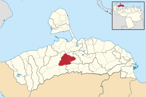
Sucre Municipality, Falcón
Appearance
Sucre Municipality
Municipio Sucre | |
|---|---|
 Location in Falcón | |
| Coordinates: 11°00′43″N 69°51′24″W / 11.0119°N 69.8567°W | |
| Country | |
| State | Falcón |
| Municipal seat | La Cruz de Taratara[*] |
| Government | |
| • Mayor | Felipe Romero |
| Area | |
• Total | 777.8 km2 (300.3 sq mi) |
| Population (2001) | |
• Total | 5,155 |
| • Density | 6.6/km2 (17/sq mi) |
| Time zone | UTC−4 (VET) |
Sucre Municipality is a municipality in Falcón State, Venezuela.[1]
Name
[edit]The municipality is one of several in Venezuela named "Sucre Municipality" in honour of Venezuelan independence hero Antonio José de Sucre.
References
[edit]- ^ "Division politico Territorial" (PDF). ine.gov.ve. Archived from the original (PDF) on 2023-03-24. Retrieved 2024-04-05.


