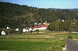
Stryszawa
Appearance
Stryszawa | |
|---|---|
Village | |
 General view | |
| Coordinates: 49°43′N 19°31′E / 49.717°N 19.517°E | |
| Country | |
| Voivodeship | Lesser Poland |
| County | Sucha |
| Gmina | Stryszawa |
| First mentioned | 1480 |
| Population | 5,100 |
Stryszawa [strɨˈʂava] is a village, the seat of the administrative district of Gmina Stryszawa, within Sucha County, Lesser Poland Voivodeship, in southern Poland.[1] It lies approximately 2 kilometres (1 mi) east of Lachowice, 6 km (4 mi) south-west of Sucha Beskidzka, and 49 km (30 mi) south-west of the regional capital Kraków.
The village was established in the second half of the 15th century by Słupski family, the owners of Sucha, and was first mentioned in 1480.[2]
References
[edit]Wikimedia Commons has media related to Stryszawa.
- ^ "Central Statistical Office (GUS) - TERYT (National Register of Territorial Land Apportionment Journal)" (in Polish). 2008-06-01.
- ^ Truś, Radosław (2008). Beskid Mały. Przewodnik. Pruszków: Oficyna Wydawnicza „Rewasz“. p. 313. ISBN 978-83-89188-77-9.

