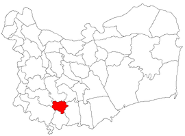
Stejaru, Tulcea
Stejaru | |
|---|---|
 Location in Tulcea County | |
| Coordinates: 44°46′N 28°33′E / 44.767°N 28.550°E | |
| Country | Romania |
| County | Tulcea |
| Subdivisions | Mina Altân Tepe, Stejaru, Vasile Alecsandri |
| Government | |
| • Mayor (2020–2024) | Enache Dumitru[1] (PNL) |
| Area | 48.29 km2 (18.64 sq mi) |
| Elevation | 190 m (620 ft) |
| Population (2021-12-01)[2] | 1,242 |
| • Density | 26/km2 (67/sq mi) |
| Time zone | EET/EEST (UTC+2/+3) |
| Postal code | 827215 |
| Vehicle reg. | TL |
| Website | www |
Stejaru is a commune in Tulcea County, Northern Dobruja, Romania. It is composed of three villages: Mina Altân Tepe, Stejaru (historical names: Eschibaba, Karapelit), and Vasile Alecsandri.
The commune is located in the south-central part of the county, 53 km (33 mi) south of the county seat, Tulcea, and 95 km (59 mi) north of Constanța, the largest port on the Black Sea.
In Stejaru there is the most compact Aromanian community of Romania. The Aromanian language is taught in the schools of the commune.[citation needed]
The Altân Tepe copper mine is situated on the territory of the commune; after operating for 105 years, the mine was closed in 2003 due to non-profitability.[3]
Stadionul Săgeata is a multi-purpose stadium in Stejaru; built in 1960, this is the home ground of the football club Săgeata Stejaru.
References
[edit]- ^ "Results of the 2020 local elections". Central Electoral Bureau. Retrieved 14 June 2021.
- ^ "Populaţia rezidentă după grupa de vârstă, pe județe și municipii, orașe, comune, la 1 decembrie 2021" (XLS). National Institute of Statistics.
- ^ Popa, Liliana (15 January 2009). "Satul minier Altân Tepe, polul sărăciei din sud-estul României". Financiarul (in Romanian). Archived from the original on 18 August 2010. Retrieved 25 August 2022.


