St Mary's Church, Prittlewell
| St Mary's Church, Prittlewell | |
|---|---|
| St. Mary's Parish Church, Prittlewell | |
 St Mary's Church, Prittlewell, Southend-on-Sea | |
 | |
| 51°32′56″N 0°42′18″E / 51.5489°N 0.7051°E | |
| Location | East Street, Prittlewell, Southend |
| Country | England |
| Denomination | Anglican |
| Website | www |
| History | |
| Status | Parish church |
| Founded | 7th century |
| Founder(s) | Saxons |
| Dedication | St Mary |
| Architecture | |
| Functional status | Active |
| Heritage designation | Grade I[1] |
| Designated | 1951 |
| Architectural type | Church |
| Style | Saxon[2] |
| Completed | 7th century |
| Administration | |
| Province | Canterbury |
| Diocese | Chelmsford |
| Parish | Prittlewell |
St Mary's Church is a Grade I listed parish church in the suburb of Prittlewell in the city of Southend-on-Sea, in the ceremonial county of Essex, England. It is the largest and one of the oldest churches in Essex. The church is open for worship. community events and other functions as well as its church hall on Victoria Avenue in the city and both its low phase school on East Street and upper phase school on Boston Avenue which are part of the Church of England's educational institution.[3]
Architecture
[edit]The church was founded in the 7th century as a chapel by the Saxons. From the 12th century until the 17th century it was added to, and became the largest church in the county of Essex, as well as one of the oldest churches in the county. The church is also the largest in both Southend and South East Essex.[4]
Gallery
[edit]-
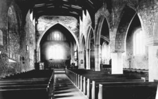
The interior of the church in 1891
-
The church from Southend Victoria railway station in the 1950s
-
The church from the northeast end of the building
References
[edit]- ^ Stuff, Good. "Church of St Mary, Prittlewell, Southend-on-Sea". britishlistedbuildings.co.uk. Retrieved 4 September 2022.
- ^ "Welcome!". St Mary's Church, Prittlewell. Retrieved 4 September 2022.
- ^ "St Mary's Prittlewell C of E Primary School Redesign". www.st-marysprittlewell.com. Retrieved 4 September 2022.
- ^ Holmes, Katherine. "History of Southend". Southend-on-Sea City Council. Retrieved 4 September 2022.


