St Julian's Pier
Appearance
St Julian's Pier is a pier in Saint Peter Port Harbour, Guernsey.[1][2]
The pier runs from the base of St Julian's Avenue, where a roundabout is now located, eastwards.

The cambridge berth is a later construction built at right angles to the pier, in a southerly direction as is the New Jetty and at the eastern extremity, the White Rock Pier.
To the north of the pier is the Queen Elizabeth II marina.
Monuments and memorials
[edit]The pier has a number of monuments and memorials[3]
- 50th Anniversary liberation monument in the form of a large obelisk and sundial.
- Liberation stone
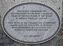
- Plaque commemorating the evacuation of children and adults ahead of the Occupation of the Island by German forces in June 1940
- Plaque to victims of the Holocaust
- Plaque to remember the Deportees
- Harbour bombing memorial
- Plaque to remember the Foreign Workers
- Guernsey Resistance plaque[4]
References
[edit]- ^ Chris Leadbeater, Guernsey travel tips: Where to go and what to see in 48 hours, The Independent, 3 April 2015
- ^ Chris Leadbeater, Guernsey and Jersey: the ghosts of occupation linger in all corners, The Telegraph Travel, 31 March 2015
- ^ "La Piaeche d'la Liberétiaon". Guernsey Museums.
- ^ "Guernsey occupation resistance plaque unveiled". BBC. 4 May 2015.
49°27′31″N 2°31′55″W / 49.45861°N 2.53194°W
