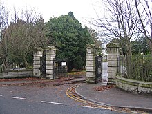
Springbank Cemetery, Aberdeen
Appearance
| Springbank Cemetery | |
|---|---|
 Cemetery Lodge, Springbank Cemetery (2012) | |
 | |
| Details | |
| Established | 1884 |
| Location | |
| Country | Scotland |
| Coordinates | 57°07′55″N 2°08′47″W / 57.1320007°N 2.146368°W |
| Owned by | Aberdeen City Council |
| Size | 15 hectares (37 acres) |
| No. of graves | 23,000+ |
| Find a Grave | [1] |
Springbank Cemetery is located on Countesswells Road, Aberdeen.[1] It opened in 1884.

The cemetery is operated by the local authority, Aberdeen City Council, is one of seventeen cemeteries in Aberdeen.[2] It is located on Countesswells Road with entrances on both Countesswells Road and Springfield Road where the cemetery lodge is situated.
According to Historic Environment Scotland, at the south-west corner of the cemetery there formerly stood Springbank Cottage.[3]
Notable graves
[edit]The cemetery contains 95 war graves, 36 from the First World War and 59 from the Second World War[4]
- William Dove Paterson a pioneer of early cinema
- James Reid Rust Lord Provost of Aberdeen and Lord Lieutenant of Aberdeenshire
- Sir James Taggart, Lord Provost of Aberdeen 1914 to 1919
References
[edit]- ^ "Springbank Cemetery on Billion Graves website". Retrieved 25 November 2019.
- ^ "Aberdeen City Council official page on burial grounds". Retrieved 25 November 2019.
- ^ "Aberdeen, Springbank Cemetery | Canmore". canmore.org.uk. Retrieved 25 November 2019.
- ^ "Commonwealth War Graves Commission". www.cwgc.org. Retrieved 25 November 2019.

