Spišský Štiavnik
Appearance
Spišský Štiavnik | |
|---|---|
Municipality | |
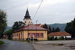
 Village center | |
| Coordinates: 48°59′42″N 20°21′36″E / 48.99500°N 20.36000°E | |
| Country | Slovakia |
| Region | Prešov |
| District | Poprad |
| First mentioned | 1246 |
| Area | |
• Total | 18.24[2] km2 (7.04[2] sq mi) |
| Elevation | 563[3] m (1,847[3] ft) |
| Population (2021) | |
• Total | 2,722[1] |
| Postal code | 059 14[3] |
| Area code | +421 52[3] |
| Car plate | PP |
| Website | www.spisskystiavnik.e-obce.sk |
Spišský Štiavnik (Hungarian: Savnik, German: Schawnik or Schafing) is a village and municipality in Poprad District in the Prešov Region of northern Slovakia.
Geography
[edit]The municipality lies at an altitude of 567 metres and covers an area of 18.364 km2. It has a population of about 2150 people.
History
[edit]In historical records the village was first mentioned in 1246.
Famous people
[edit]- Tibor Frešo, composer and conductor
- Prof. Martin Slivka, ethnography director
Infrastructure and economy
[edit]Cultural sightseeing is a building of former spas from the 19th century. In the Spišský Štiavnik is multi course as well as football and horse racing clubs.
References
[edit]- ^ "Počet obyvateľov podľa pohlavia - obce (ročne)". www.statistics.sk (in Slovak). Statistical Office of the Slovak Republic. 2022-03-31. Retrieved 2022-03-31.
- ^ a b "Hustota obyvateľstva - obce [om7014rr_ukaz: Rozloha (Štvorcový meter)]". www.statistics.sk (in Slovak). Statistical Office of the Slovak Republic. 2022-03-31. Retrieved 2022-03-31.
- ^ a b c d "Základná charakteristika". www.statistics.sk (in Slovak). Statistical Office of the Slovak Republic. 2015-04-17. Retrieved 2022-03-31.
- ^ a b "Hustota obyvateľstva - obce". www.statistics.sk (in Slovak). Statistical Office of the Slovak Republic. 2022-03-31. Retrieved 2022-03-31.
External links
[edit]


