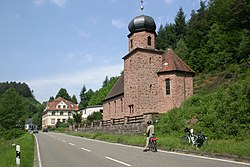
Speyerbrunn
Appearance
Speyerbrunn | |
|---|---|
hamlet | |
 | |
| Coordinates: 49°20′59″N 7°52′16″E / 49.34972°N 7.87111°E | |
| country | Germany |
| state | Rhineland-Palatinate |
| Landkreis | Bad Dürkheim |
| municipality | Elmstein |
| Named for | Speyerbach |
| Highest elevation | 337 m (1,106 ft) |
| Lowest elevation | 312 m (1,024 ft) |
| Population | |
• Total | 100 |
| Postleitzahl | 67471 |
| Area code | +49 6328 |
Speyerbrunn is a community of the municipality Elmstein in the Landkreis of Bad Dürkheim in Rhineland-Palatinate, Germany
Location
[edit]It is located in Palatinate forest about 3 mi (4.8 km) west of Elmstein.
History
[edit]Speyerbrunn was founded in 1754. Until 1975 the town belonged to the municipality Wilgartswiesen, which was merged with the neighboring towns Schwarzenbach, Erlenbach and Elmstein in a local government reform on January 1, 1976.

