South Station (subway)
South Station | |||||||||||||||||||||||||||||||||||||||||||||||||||||||||||||||||||||||||||||||
|---|---|---|---|---|---|---|---|---|---|---|---|---|---|---|---|---|---|---|---|---|---|---|---|---|---|---|---|---|---|---|---|---|---|---|---|---|---|---|---|---|---|---|---|---|---|---|---|---|---|---|---|---|---|---|---|---|---|---|---|---|---|---|---|---|---|---|---|---|---|---|---|---|---|---|---|---|---|---|---|
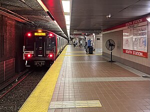
 A southbound Red Line train departing South Station in May 2024 | |||||||||||||||||||||||||||||||||||||||||||||||||||||||||||||||||||||||||||||||
| General information | |||||||||||||||||||||||||||||||||||||||||||||||||||||||||||||||||||||||||||||||
| Other names | South Station Under | ||||||||||||||||||||||||||||||||||||||||||||||||||||||||||||||||||||||||||||||
| Location | Atlantic Avenue and Summer Street Boston, Massachusetts | ||||||||||||||||||||||||||||||||||||||||||||||||||||||||||||||||||||||||||||||
| Coordinates | 42°21′09″N 71°03′19″W / 42.35261°N 71.05536°W | ||||||||||||||||||||||||||||||||||||||||||||||||||||||||||||||||||||||||||||||
| Line(s) | Cambridge-Dorchester Tunnel (Red Line) South Boston Transitway (Silver Line) | ||||||||||||||||||||||||||||||||||||||||||||||||||||||||||||||||||||||||||||||
| Platforms | 2 side platforms (Red Line) 2 side platforms (Silver Line tunnel) 1 side platform (Silver Line street) | ||||||||||||||||||||||||||||||||||||||||||||||||||||||||||||||||||||||||||||||
| Tracks | 2 (Red Line) | ||||||||||||||||||||||||||||||||||||||||||||||||||||||||||||||||||||||||||||||
| Connections | |||||||||||||||||||||||||||||||||||||||||||||||||||||||||||||||||||||||||||||||
| Construction | |||||||||||||||||||||||||||||||||||||||||||||||||||||||||||||||||||||||||||||||
| Structure type | Underground | ||||||||||||||||||||||||||||||||||||||||||||||||||||||||||||||||||||||||||||||
| Bicycle facilities | "Pedal and Park" bicycle cage | ||||||||||||||||||||||||||||||||||||||||||||||||||||||||||||||||||||||||||||||
| Accessible | Yes | ||||||||||||||||||||||||||||||||||||||||||||||||||||||||||||||||||||||||||||||
| History | |||||||||||||||||||||||||||||||||||||||||||||||||||||||||||||||||||||||||||||||
| Opened | August 22, 1901 (Atlantic Avenue Elevated)[1] December 3, 1916 (Red Line)[2][1] December 17, 2004 (Silver Line)[1] | ||||||||||||||||||||||||||||||||||||||||||||||||||||||||||||||||||||||||||||||
| Closed | September 30, 1938 (Atlantic Avenue Elevated)[1] | ||||||||||||||||||||||||||||||||||||||||||||||||||||||||||||||||||||||||||||||
| Rebuilt | 1988–1993, 2002–2004 | ||||||||||||||||||||||||||||||||||||||||||||||||||||||||||||||||||||||||||||||
| Passengers | |||||||||||||||||||||||||||||||||||||||||||||||||||||||||||||||||||||||||||||||
| FY2019 | 24,639 (weekday average boardings)[3] | ||||||||||||||||||||||||||||||||||||||||||||||||||||||||||||||||||||||||||||||
| Services | |||||||||||||||||||||||||||||||||||||||||||||||||||||||||||||||||||||||||||||||
| |||||||||||||||||||||||||||||||||||||||||||||||||||||||||||||||||||||||||||||||
| |||||||||||||||||||||||||||||||||||||||||||||||||||||||||||||||||||||||||||||||
| |||||||||||||||||||||||||||||||||||||||||||||||||||||||||||||||||||||||||||||||
| |||||||||||||||||||||||||||||||||||||||||||||||||||||||||||||||||||||||||||||||
South Station (also signed as South Station Under) is a transfer station on the MBTA rapid transit Red Line and bus rapid transit Silver Line, located at Summer Street and Atlantic Avenue in downtown Boston, Massachusetts. It is a part of the complex of the same name, the second busiest transportation center in New England.[4] Eight MBTA Commuter Rail and three Amtrak intercity rail services terminate at South Station; many of those passengers then transfer to the rapid transit lines to reach other destinations in the city. With 24,639 daily boardings in 2019, South Station is the busiest station on the MBTA rapid transit system.[3]
Station layout
[edit]
South Station has three underground levels. The Red Line runs under Summer Street at the lowest level, with two side platforms serving the line's two tracks. The Silver Line runs under Atlantic Avenue on the middle level, with two side platforms serving the subway. A fare mezzanine is just below street level, with stairs, escalators, and elevators to the platforms below. It has entrances at street level on all four corners of the intersection of Summer Street and Atlantic Avenue, with elevators at the north and south corners.[5] An accessible passage also connects the mezzanine with the interior of the South Station terminal, served by Amtrak and MBTA Commuter Rail trains.
Silver Line route SL4 runs on the surface rather than the underground busway; it stops on Essex Street at Atlantic Avenue.[6][7] MBTA bus routes 4, 7, and 11 stop on Summer Street near Atlantic Avenue.[8] South Station Bus Terminal, the main intercity bus terminal in Boston, is located over the South Station platforms.
History
[edit]
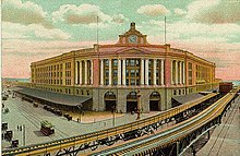
A station serving South Station was located on the Atlantic Avenue Elevated. Service on the Atlantic Avenue "El" was discontinued on September 20, 1938. The structure itself was torn down in the spring of 1942. Before stairs were added, passengers wishing to change lines from the underground station—itself opened on December 3, 1916—had to use a paper transfer and go outside to change trains.[9] The underground station had four staircases and one escalator leading from the surface to the mezzanine, and two exit escalators.[10]
In 1957, the original fare lobby and the rounded top of the tunnel to the west were removed during construction of the Dewey Square Tunnel. The tunnel was rebuilt with a flat ceiling, while the fare lobby was moved to the east closer to the South Station headhouse.[11] In the 1970s, an artwork by Sylvana Cenci entitled Wheels in Motion was placed in the station. Cenci created the artwork by using explosives to warp a steel plate. She had previously been runner-up in a 1971 competition for public art at State station.[12][13]

A second renovation began around 1980. An entrance was also added to the Federal Reserve Bank Building as well as a passageway under Summer Street connecting the other street entrances. In 1985, the Red Line platforms were extended 60 feet on either end to allow 6-car trains.[9] A passageway between the Red Line lobby and the interior of South Station opened in June 1990.[14]
The final renovation was triggered by the Big Dig highway project. Since the Red Line tunnel beneath Summer Street is perpendicular to Atlantic Avenue, where the new I-93 northbound tunnel was to be built, builders had to tunnel under the tracks. After the first tunnel was complete, another tunnel was added along with a station for the Silver Line. Since the new tunnel was built at the former fare level, another fare level was constructed a level above. This allowed combined access for the Silver and Red lines. The original lobby that was destroyed was replaced by stairways.[9] This project was completed at a cost of $35 million.[15] An additional $13 million renovation of the Red Line level was undertaken.[16]
After the first sections of the Silver Line opened in 2002 and 2004, a Phase III was proposed which would build a tunnel connecting South Station and the South Boston Waterfront section with the Washington Street section of the line. In 2010, the project was placed on indefinite hold.[17] However, route SL4, operating to a surface stop on Essex Street at Atlantic Avenue, began service on October 13, 2009.[7]
In early 2005, a blue and white tile mosaic reading 'South Station Under' was discovered during renovations to the Red Line platform. The MBTA had the mosaic restored to its original condition during the project.[18] Network, a 650-square-foot (60 m2) glass mosaic map by Ellen Harvey, was built on the interior walls of the northeast headhouse in 2019.[19] Plans for wayfinding signage, lighting, and other station improvements were completed by May 2021.[20]
References
[edit]- ^ a b c d Belcher, Jonathan. "Changes to Transit Service in the MBTA district" (PDF). Boston Street Railway Association.
- ^ "New Tunnel Station is Opened". Boston Daily Globe. December 4, 1916. p. 5 – via Newspapers.com.

- ^ a b "A Guide to Ridership Data". MassDOT/MBTA Office of Performance Management and Innovation. June 22, 2020. p. 6.
- ^ Project for Public Spaces Archived 2013-06-24 at the Wayback Machine, Retrieved December 31, 2010
- ^ "South Station Neighborhood Map" (PDF). Massachusetts Bay Transportation Authority. April 2012. Archived from the original (PDF) on March 22, 2015.
- ^ "South Station Direct Connect". MassDOT. Archived from the original on October 25, 2009. Retrieved December 31, 2010.
- ^ a b "Patrick-Murray Administration, Mayor Menino Launch Silver Line Direct Connect Service to South Station" (Press release). Massachusetts Bay Transportation Authority. October 13, 2009.
- ^ "2023–24 System Map". Massachusetts Bay Transportation Authority. December 17, 2023.
- ^ a b c O'Regan, Gerry (2012). "MBTA Red Line". nycsubway.org. David Pirmann. Retrieved 27 January 2014.
- ^ ""South Station Under" Opens Tomorrow". Boston Globe. December 2, 1916. p. 16 – via Newspapers.com.

- ^ Tsipis, Yanni K. (2001-02-01). Boston's Central Artery. Arcadia. p. 96. ISBN 9780738505268.
- ^ Alonso, Jessica (April 5, 1977). "Art from underground". Boston Globe. p. 20 – via Newspapers.com.

- ^ Kay, Jane Holtz (July 11, 1971). "A look at some underground art". Boston Globe. p. 186 – via Newspapers.com.

- ^ "Kinder to pedestrians". The Boston Globe. June 23, 1990 – via Newspapers.com.
- ^ Intermodal Stations Archived 2011-07-26 at the Wayback Machine. Retrieved December 31, 2010
- ^ "Accessibility Projects at the MBTA" (PDF). Massachusetts Bay Transportation Authority. March 2005.
- ^ Annual Status Report to DEP Archived 2016-03-03 at the Wayback Machine, July 9, 2010
- ^ Daniel, Mac (23 January 2005). "South Bay shoppers don't rush home with their treasures". Boston Globe. Retrieved 9 May 2014.
- ^ "WTS-Boston unveils public art celebrating women in transportation at South Station". New England Real Estate Journal. June 28, 2019.
- ^ Brelsford, Laura (May 24, 2021). "System-Wide Accessibility Initiatives—May 2021" (PDF). Massachusetts Bay Transportation Authority Department of System-Wide Accessibility. p. 5.

