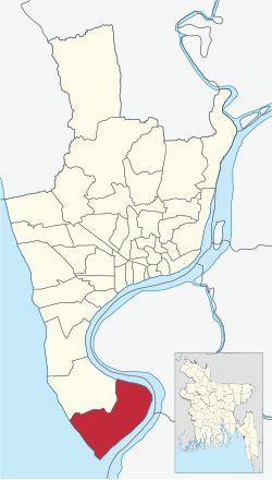
South Patenga Ward
Appearance
This article needs additional citations for verification. (June 2023) |
South Patenga
দক্ষিণ পতেঙ্গা | |
|---|---|
 | |
| Coordinates: 22°14.5′N 91°49′E / 22.2417°N 91.817°E | |
| Country | |
| Division | Chittagong Division |
| District | Chittagong District |
| City | Chittagong |
| Jatiya Sangsad constituency | Chittagong-11 |
| Formed | 1989 |
| Government | |
| • Type | Mayor–Council |
| • Body | Chattogram City Corporation |
| • Councillor | Vacant |
| Area | |
• Total | 17.26 km2 (6.66 sq mi) |
| Population (2011) | |
• Total | 44,084 |
| • Density | 2,600/km2 (6,600/sq mi) |
| Time zone | UTC+6 (BST) |
| Postal code | 4202/4222 |
| Website | ccc.gov.bd |
South Patenga (Bengali: দক্ষিণ পতেঙ্গা) is a No.41 Ward of Chattogram City Corporation[1] and a part of Patenga Thana, Bangladesh.[2]
References
[edit]- ^ Ismail M M Rahman; et al. (2010). "Stagnant surface water bodies (SSWBs) as an alternativewater resource for the Chittagong metropolitan area of Bangladesh: physicochemical characterization in terms of water quality indices". Environmental Monitoring and Assessment. 173 (1–4): 669–684. doi:10.1007/s10661-010-1414-7. hdl:2297/26534. PMID 20300834. S2CID 37730953.
- ^ Palit, Tapan (2012). "Chittagong City Corporation". In Islam, Sirajul; Jamal, Ahmed A. (eds.). Banglapedia: National Encyclopedia of Bangladesh (Second ed.). Asiatic Society of Bangladesh.
