Solskjel
Appearance
 | |
| Geography | |
|---|---|
| Location | Møre og Romsdal, Norway |
| Coordinates | 63°14′40″N 8°11′19″E / 63.2445°N 8.1886°E |
| Area | 5 km2 (1.9 sq mi) |
| Length | 3 km (1.9 mi) |
| Width | 2.5 km (1.55 mi) |
| Coastline | 15 km (9.3 mi) |
| Highest elevation | 87 m (285 ft) |
| Highest point | Storhaugen |
| Administration | |
Norway | |
| County | Møre og Romsdal |
| Municipality | Aure Municipality |
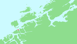
Solskjel or Solskjelsøya is an island in Aure Municipality in Møre og Romsdal county, Norway.[1] The 5-square-kilometre (1.9 sq mi) island sits just north of the island of Stabblandet, northeast of the larger island of Tustna and west of the island of Ertvågsøya.
There is no road connection to the island, but there is a cable ferry connection across the 450-metre (1,480 ft) wide Norheimsundet strait to the neighboring island of Stabblandet. The cable ferry began operating on 16 January 2009.[2]
See also
[edit]References
[edit]- ^ "Solskjel" (in Norwegian). yr.no. Retrieved 2010-12-11.
- ^ "Solskjel kabelferge" (in Norwegian). Solskjel.no. Retrieved 2019-04-11.
External links
[edit]- http://www.solskjel.no/ (in Norwegian)


