Sola (Sierra de Cubitas)
This article needs additional citations for verification. (August 2022) |
Sola | |
|---|---|
Town | |
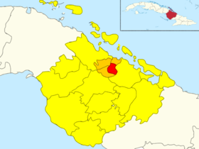
 Sola (Red) in Sierra de Cubitas (Orange) in Camagüey (Yellow) | |
Location of Sola in Cuba | |
| Coordinates: 21°40′27.8″N 77°40′50.0″W / 21.674389°N 77.680556°W | |
| Country | |
| Province | Camagüey |
| Municipality | Sierra de Cubitas |
| Founded | 1920 |
| Elevation | 35 m (115 ft) |
| Population (2011)[1] | |
• Total | 10,000 |
| Time zone | UTC-5 (EST) |
| Area code | +53-322 |
Sola is a Cuban town and consejo popular ("people's council") of the municipality of Sierra de Cubitas, in Camagüey Province.With a population (2011) of about 10,000, it is the largest settlement of its municipality, including the seat town of Cubitas.[1]
History
[edit]Founded on September 28, 1920, it was originally part of Camagüey municipality[2] until the 1977 administrative reform, when it became part of the new municipality of Sierra de Cubitas, whose seat, Cubitas, was founded in the end of 1976.[citation needed]
Geography
[edit]Located on a wide rural plain, few km south of the Atlantic Coast and the island of Cayo Guajaba,[3] Sola is divided into a pair of circumscriptions named "Sola 1" and "Sola 2". It is 8 km from La Gloria, 10 from Cubitas, 18 from Senado, 25 from Minas, 30 from Lugareño, 37 from Brasil, 50 from Nuevitas, 51 from Esmeralda and 60 from Camagüey city centre.[citation needed]
Transport
[edit]Sola is crossed to the south by the state highway "Circuito Norte" (CN), and in the middle by the provincial road 5-521. It counts a railway station on the Santa Clara-Camajuaní-Morón-Nuevitas line,[4] with local and long-distance trains, connecting the town with Havana too.
Health
[edit]The village has a general hospital named "Policlínico 13 de Marzo", located between the centre and the Circuito Norte.[5]
See also
[edit]References
[edit]- ^ a b Source: Mapa de Carreteras de Cuba (Road map of Cuba). Ediciones GEO, Havana 2011 - ISBN 959-7049-21-X
- ^ (in Spanish) Camagüey on guije.com
- ^ 1522863117 Sola on OpenStreetMap
- ^ 1252910603 Sola railway station on OpenStreetMap
- ^ Policlínico 13 de Marzo on maps.me
External links
[edit]- (in Spanish) House of Culture of Sola
- Sola Weather on accuweather.com

