Slatinky
Slatinky | |
|---|---|
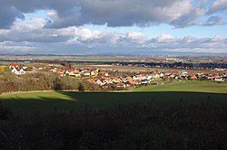
 View from the southwest | |
| Coordinates: 49°32′55″N 17°5′38″E / 49.54861°N 17.09389°E | |
| Country | |
| Region | Olomouc |
| District | Prostějov |
| First mentioned | 1247 |
| Area | |
• Total | 8.02 km2 (3.10 sq mi) |
| Elevation | 272 m (892 ft) |
| Population (2024-01-01)[1] | |
• Total | 591 |
| • Density | 74/km2 (190/sq mi) |
| Time zone | UTC+1 (CET) |
| • Summer (DST) | UTC+2 (CEST) |
| Postal code | 783 42 |
| Website | www |
Slatinky is a municipality and village in Prostějov District in the Olomouc Region of the Czech Republic. It has about 600 inhabitants.
Geography
[edit]Slatinky is located about 8 kilometres (5 mi) north of Prostějov and 11 km (7 mi) southwest of Olomouc. It lies on the border between the Upper Morava Valley and Zábřeh Highlands. The highest point of the municipality and the whole Haná region is the hill Velký Kosíř at 442 m (1,450 ft) above sea level.[2]
The Kosířské lomy National Nature Monument extends into the southern part of the municipal territory.[3]
History
[edit]The first written mention of Slatinky is from 1247. Until the establishment of an independent municipality in 1848, the village belonged mostly to the Plumlov and Chudobín estates and to the St. Catherine Monastery in Olomouc.[2]
Demographics
[edit]
|
|
| ||||||||||||||||||||||||||||||||||||||||||||||||||||||
| Source: Censuses[4][5] | ||||||||||||||||||||||||||||||||||||||||||||||||||||||||
Transport
[edit]The railway line Prostějov–Červenka passes through the eastern part of the municipality, but there is no train station. The municipality is served by the station Třebčín in neighbouring Lutín.
Sights
[edit]
Slatinky is poor in monuments. The only protected cultural monument is an archaeological site with 36 tumuli from 5800 to 5000 BC.[6]
The main landmark of Slatinky is the Chapel of Saints John and Paul. It dates from 1822.[7]
References
[edit]- ^ "Population of Municipalities – 1 January 2024". Czech Statistical Office. 2024-05-17.
- ^ a b "Historie" (in Czech). Obec Slatinky. Retrieved 2022-02-11.
- ^ "Kosířské lomy". Ústřední seznam ochrany přírody (in Czech). Nature and Landscape Protection Agency of the Czech Republic. Retrieved 2022-10-13.
- ^ "Historický lexikon obcí České republiky 1869–2011" (in Czech). Czech Statistical Office. 2015-12-21.
- ^ "Population Census 2021: Population by sex". Public Database. Czech Statistical Office. 2021-03-27.
- ^ "Výsledky vyhledávání: Kulturní památky, obec Slatinky". Ústřední seznam kulturních památek (in Czech). National Heritage Institute. Retrieved 2024-07-24.
- ^ "Oprava Kaple sv. Jana a Pavla" (in Czech). Obec Slatinky. Retrieved 2024-05-07.


