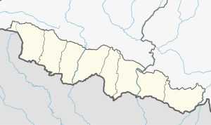
Simraungadh (Municipality)
Simraungadh | |
|---|---|
Municipality | |
 | |
| Coordinates: (26.8893386, 85.1168150)26°53′22″N 85°7′1″E / 26.88944°N 85.11694°E | |
| Country | Nepal |
| Province | Madhesh Province |
| District | Bara District |
| Government | |
| • Mayor | Kishori Sah Kalwar (Loktantrik Samajwadi Party, Nepal) |
| • Deputy Mayor | Najmu Sehar (Loktantrik Samajwadi Party, Nepal) |
| Area | |
| • Total | 42.65 km2 (16.47 sq mi) |
| Population (2011) | |
| • Total | 49,939 |
| Time zone | UTC+5:45 (NST) |
| Website | www.simraungadhmun.gov.np |
Simraungadh, Simraongarh or Simroungarh (/ˈsiːmraʊnɡɜːr/, Devanagari: सिम्रौनगढ) is a municipality situated in Bara district of Nepal.
The municipality was created in 2014 by agglomerating the Village Development Committees of Amritganj, Golaganj, Hariharpur & Uchidih and later on expanded the municipality areas to include Bhagwanpur, Kachorwa, Dewapur-Teta, and Bishnupur,BadkaItwal]].[1][2][3][4][5]
The municipality is also contains parts of an archaeological site which is split between Indian and Nepal and which finds mention in the travel accounts of a Tibetan monk and pilgrim, Dharmasvamin (1236)[6][7] when he was on his way back to Nepal And Tibet, an Italian Missionary traveler, Cassiano Beligatti (1740),[8][9] Colonel James Kirkpatrick (1801) on his mission to Nepal[10] and later used in 1835 by British ethnologist Brian Houghton Hodgson.[11]
The city is located along the border between India and Nepal. It lies 90 km (56 mi) south of Nepal's capital, Kathmandu, and 28 km (17 mi) east of Birgunj metro city.[12] Bhojpuri is the local language of Simraungadh.[13]
Etymology
[edit]The name Simraon comes from the local language Simr which stands for Simal tree found in the area.[14][15] Simraongarh's relationship with the Simal forest has been also revealed by Gopal Raj Vamshavali, the oldest chronicles of Nepal.[16] The Tibetan monk and traveler, Dharmasavamin states Simrāongarh as Pa-ta.[17] The word Pata is an abbreviation of last affix of 'Pattana', which means a capital in Sanskrit language.[17]
History
[edit]Simraungadh was the capital of an independent Hindu kingdom of the Mithila or Tirhut from the 11th century to early 14th century.[18][19][20][21] The fortified city was built along the present-day border between India and Nepal. The rule of the Karnat dynasty marks an important milestone and a golden age in the history of Tirhut.[22] The rise of this empire saw the birth of efficient administration, social reforms, religious and the development of local folk music and literature.[23][24]
Karnat dynasty
[edit]The Simraon, Karnat, or Dev Dynasty originated with the establishment of a kingdom in 1097 CE headquartered at present-day Simraungadh in Bara district. The kingdom controlled the areas we today know as Tirhut or Mithila in India and Nepal. This region is bounded by the Mahananda River in the east, the Ganges in the south, the Gandaki River in the west, and by the Himalayas in the north.[25][26] The boundary line was made between the two countries after the Treaty of Sugauli in 1816 CE.
According to French orientalist and indologist Sylvain Lévi, Nanyadeva established his supremacy over Simraungadh probably with the help of Chalukya king Vikramaditya VI.[27][28][29] After the reign of Vikramaditya VI in 1076 CE, he led the successful military campaign over modern Bengal and Bihar.[30][31]
The rulers of Simraongarh are as follows:
| S.N. | Name of the rulers | Timeline | Notes |
|---|---|---|---|
| 1 | Nanya Dev[11] | 1097 - 1147 CE[32] | |
| 2 | Gangadeva[11] | 1147 - 1187 CE[32] | |
| 3 | Narsimhadeva[11] | 1187 - 1227 CE[32] | |
| 4 | Ramasimhadeva[11] | 1227 - 1285 CE[32] | |
| 5 | Shaktisimhadeva[11] | 1285 - 1295 CE[32] | |
| 6 | Harisingh Dev[11] | 1295 - 1324 CE[32] |
Geography and climate
[edit]Simraungadh is located at 26°53′22″N 85°7′1″E / 26.88944°N 85.11694°E. It has an average elevation of 83 meters.[33] The Simraungdah town lies on the flat and fertile plain of Terai. In the south, the city borders Bijwani in the border of the Indian state of Bihar, while Adarsh Kotwal in the north.
Tourist attractions
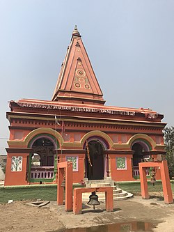
[edit]Ranivas Temple and Palace
[edit]Ranivas Complex comprises 'Ranivas Temple' which is also known as 'Ram Mandir', 'Ram Janaki Mandir', 'Ranivas Palace' and 'Mahal Sarai'[11] is located 1 Kilometer north of Simraungadh market area and 2 Kilometer north of the Indian border. The complex is spread in 600 bighas. It is one of the most visited sites of Simraungadh by local and foreign tourists. The present Ram Janaki temple is built in 1878 AD by Jagat Jung Rana, son of Jung Bahadur Rana.[34][35] In 1877 AD, then Prime Minister Jung Bahadur Rana died at a place called Patharghat, Rautahat while returning from a hunting camp from Simraungadh. According to the wish expressed by his queen Hiranya Garbha Devi while going to Sati, his son built this temple in 1878 AD.[36]
It is said and believed that this temple and present structure of Ranivas Palace is built upon the ancient palace of the Karnat dynasty.[37] After the fall of Karntas, Oiniwar dynasty comes into the power who ruled Mithila region from 1325 to 1527 AD. It is also believed that the Maharaja of Oinwar dynasty, Siva Singh (r. 1412 - 1416),[38] built this palace for his daughter Isri Devi during his ruling time.[39][34]
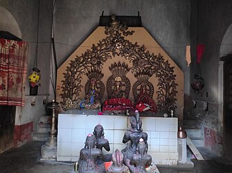
Kankali Temple
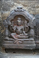
[edit]Kankali Temple is a Hindu temple located in the southeastern part of the Simraungadh market area. This temple is built in the shikhara style of architecture.[40][41] The idol of Kankali Mai is placed in the temple, which is made of black stone and believed to be mangled by Tughlaq armies. The date L.S. 119 (which must be in Vikram Samvat: 1340 and Common era: 1283) is engraved on the Ghanta, which is placed in front of this temple. Before the renovation of this temple, the ruin of this temple was known as "Kankali Mai Sthaan". The temple was restored in a small size by Mansaram Baba before 1816 AD and the present structure was made by his disciple, Ram Sewak Das in 1967 AD. During the festivals of Rama Navami in Chaitra, there is the presence of thousands of worshipers from Nepal and India.[34]
Jharokhar Pokhari
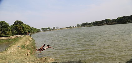
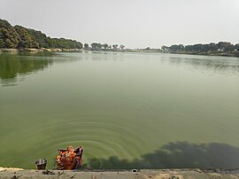
[edit]Jharokhar Pokhari, 'Deutaal Pokhari' or 'Kachorwa Pokhari' is an artificial pond spread in 52 bighas (87 acres).[42] As of 2020 AD, the pond is shrunk to 22 bighas (36 acres) due to a lack of maintenance and human encroachment.[43] The Jharokhar pond, which is connected to the Nepal-India border by Dasgaja, is believed to be about 800 years old and is located in Baswariya, Simraungadh. There is an Indian village, Jharokhar which is about two hundred meters south of the pond. This is one of the largest man-made spring pond of Nepal.[44][45]
Medieval city plan and fortification
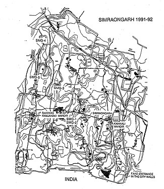
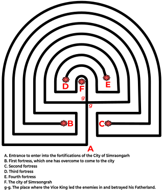
[edit]The medieval city of Simraungadh is enclosed within an impressive system of earthen ramparts and infilled ditches.[46][47] The fortification of the medieval city has a rectangular shape and ground plan. The fortifications of Simraungadh are called Baahi locally[48] and remembered as a Labyrinth.[49] The fort is spread in 6 Kos[50] and the main enclosure is about 7.5 km north–south and 4.5 km east–west.[12] The eastern and western side of the fort were built over two natural embankments. The western side of the fort was dry in comparison to eastern side.[47] The Labyrinth and the powerful defense system of the city was well planned to protect from the river floods, enemies and regulate agriculture from controlled flow of water from the ditches shows the ability of the Kingdom.
During the reign of Rama Singh Deva (r. 1227 - 1285 CE) over Simraungadh, the Tibetan monk Dharmasvamin visited the fortified city in 1236 AD on his way back to Nepal and Tibet from Nalanda. He made the following remarks regarding the palace and fortification system of Pa-ta (Simraungadh),
The city was surrounded by seven tall walls, and the palace had eleven large gates and was surrounded by 21 ditches filled with water and rows of trees. The height of the city walls was equal to that of a Tibetan fort. The protective measures were taken due to Tughlaq armies, who led an army expedition but failed to reach it.[6]
After the fall and decline of the Karnat dynasty from Simraungadh,[51] the region was either controlled by Oiniwar rulers or Makwanpur rulers[36] until the Unification of Nepal in 1768 AD.[52] During the period of time an Italian Missionary traveller Cassiano Beligatti, with seven other missionaries reached this place on their way to Kathmandu valley from Patna on 29 February 1740.[53] He describes his journey on his travelling manuscript about this place is as follows,
There were some old ruins, and some seemed to be remains of substantial buildings. The city was situated in the quasi-labyrinth enclosed by high walls and was impossible to enter except on a single spot. There were four fortresses, which were evenly distributed from place to place within the enclosures of the labyrinth; and these enclosures had a distance from one side to the other of about a Kos or two miles, and the walls were extremely high with a width in proportion.[54]
References
[edit]- ^ Magazine, New Spolight. "Nepal government declares 61 new municipalities". SpotlightNepal. Retrieved 2019-02-03.
- ^ "PM formally announces 744 local units operational". My Republica. Archived from the original on 13 August 2018. Retrieved 13 August 2018.
- ^ "स्थानिय तह" [Local Unit]. 103.69.124.141. Archived from the original on 31 August 2018. Retrieved 1 September 2018.
- ^ "Population Ward Level 753 Local Unit" (PDF). CBS. 2 June 2017. Archived (PDF) from the original on 27 January 2018.
- ^ Nepal, Government of Nepal (November 2012). ""National Population and Housing Census 2011 (Village Development Committee/Municipality)" (PDF). National Planning Commission. Archived (PDF) from the original on 21 December 2016.
- ^ a b Roerich, George Dr. (1959). "Biography Of Dharmasvamin (1959)". K.P. Jayaswal Research Institute: 18.
- ^ Chaudhary P. C. Roy (1964). "Bihar District Gazetteers Darbhanga".
{{cite journal}}: Cite journal requires|journal=(help) - ^ Petech, Luciano (1952). I missionari italiani nel Tibet e nel Nepal (in Italian). Libreria dello Stato. p. 809.
- ^ Ippolito, Desideri (1995). An account of Tibet : the travels of Ippolito Desideri, 1712-1727. New Delhi: Asian Educational Services. pp. 322–323. ISBN 978-8120610194. OCLC 33941427.
- ^ Aitchison.c.u (1910). "The Treaties Amp Relating To Hyderabad Mysore And Coorg". Retrieved 2019-02-03.
- ^ a b c d e f g h Hodgson, B. H. (1835). "Account of a Visit to the Ruins of Simroun, once the capital of the Mithila province". Journal of the Asiatic Society. 4: 121−124.
- ^ a b Sah, Bharat. "सिम्रौनगढ : सम्पदा संरक्षणमा चुनौती" [Simraungadh: Challenge in heritage conservation]. Online Khabar (in Nepali). Retrieved 2019-02-10.
- ^ Gopal Thakur Lohar (2006-06-04). A Sociolinguistic Survey of the Bhojpuri Language in Nepal.
- ^ Michael, Bernardo A. (2014-10-01). Statemaking and Territory in South Asia: Lessons from the Anglo–Gorkha War (1814–1816). Anthem Press. ISBN 9781783083220.
- ^ Darnal, Prakash (2018). "A Review of Simraongarh's History on Its Nexus Areas with References of Archeological Evidences". DSAJ: 18–26.
- ^ "सिमरौनगढको सांस्कृतिक सम्पदा" [The cultural heritage of Simraungadh]. eHimalayatimes (in Nepali). Retrieved 2019-02-10.
- ^ a b Roerich Dr. George. (1959). "Biography Of Dharmasvamin (1959)".
{{cite journal}}: Cite journal requires|journal=(help) - ^ Parishad, Bihar Purāvid (1981). "The Journal of the Bihar Purävid Parishad, Volumes 4-5". p. 414. Retrieved 26 January 2017.
- ^ Choudhary, Radhakrishna (1970). "History of Muslim rule in Tirhut, 1206-1765, A.D." p. 28. Retrieved 26 January 2017.
- ^ Society, Bihar Research (1960). "The Journal of the Bihar Research Society, Volume 46". pp. 22–25. Retrieved 26 January 2017.
- ^ "Publications, Volume 33". 1935. p. 193. Retrieved 26 January 2017.
- ^ "ऐतिहासिक सिम्रौनगढः एक चर्चा" [Historical Simraungadh: A discussion]. Retrieved 2019-02-12.
- ^ Jha, Makhan (1997). Anthropology of Ancient Hindu Kingdoms: A Study in Civilizational Perspective. M.D. Publications Pvt. Ltd. ISBN 9788175330344.
- ^ Chaudhary, Radhakrishna (1976). Mithila In The Age Of Vidyapati (1st ed.). Chaukhambha Orientalia.
- ^ Jha, M. (1997). "Hindu Kingdoms at contextual level". Anthropology of Ancient Hindu Kingdoms: A Study in Civilizational Perspective. New Delhi: M.D. Publications Pvt. Ltd. pp. 27–42. ISBN 9788175330344.
- ^ Mishra, V. (1979). Cultural Heritage of Mithila. Allahabad: Mithila Prakasana. p. 13.
- ^ Magazine, New Spolight. "Sylvain Lévi's Le Népal". SpotlightNepal. Retrieved 2019-04-15.
- ^ Majumdar, Ramesh Chandra (1957). The Struggle For Empire. Bharatiya Vidya Bhavan, 1957. p. 47.
- ^ Levi, Sylvain (2015-02-18). Le Népal: Étude Historique D'Un Royaume Hindou - Scholar's Choice Edition. Creative Media Partners, LLC. ISBN 9781297173240.
- ^ Somers, George E. (1977). Dynastic History Of Magadha. Abhinav Publications. ISBN 9788170170594.
- ^ Mukherjee, Ramkrishna; Mukherjee, Roopali (1974). Rise and Fall East India. NYU Press. ISBN 9780853453154.
- ^ a b c d e f Chaudhary, Radhakrishna. Mithilak Itihas [मिथिलाक इतिहास] (in Hindi). Ram Vilas Sahu. pp. 70–112. ISBN 9789380538280.
- ^ "GPS and Latitude". www.gps-coordinates.net. Retrieved 2019-04-16.
- ^ a b c "The buried kingdom of Simraungadh". OnlineKhabar. 6 December 2019. Retrieved 2021-03-06.
- ^ Shrestha, Keshav (2020-09-19). "काठमाडौका बैद्य परिवारको कूल देवता सिम्रौनगढमा ?" [The deity of the Vaidya family of Kathmandu is in Simraungadh?]. Tarun Khabar (in Nepali). Retrieved 2021-03-06.
- ^ a b Yadav, Bhauch Prasad (2015-10-05). "ऐतिहासिक स्थलः बाराको सिम्रौनगढ" [Historical place: Bara's Simraungadh]. News Today (in Nepali). Retrieved 2021-03-11.
- ^ "रानीवास मन्दिर परिसरमा कर्नाटकको राजधानीको अवशेष" [Remains of the capital of Karnataka in the Ranivas temple complex]. Shilapatra (in Nepali). Retrieved 2021-03-06.
- ^ Jha, Makhan (1997). Anthropology of ancient Hindu kingdoms : a study in civilizational perspective. New Delhi: M.D. Publications. p. 57. ISBN 81-7533-034-1. OCLC 37992849.
- ^ Mithila, Incredible (2020-06-24). "Janakpur During Different Dynasties". Incredible Mithila. Retrieved 2021-03-06.
- ^ "पर्यटक पर्खंदै बाराका गन्तव्य" [Bara's destination waiting for tourists]. Karobar Daily (in Nepali). Retrieved 2021-03-09.
- ^ "Statues are being stolen from Simraungadh, but nobody is bothered". kathmandupost.com. Retrieved 2021-03-09.
- ^ Amatya, Shaphalya (2003). "Water and Culture" (PDF): 32.
{{cite journal}}: Cite journal requires|journal=(help) - ^ "आठसय वर्ष पुरानो पोखरी अतिक्रमणको चपेटामा" [Eight hundred year old pond in the grip of encroachment]. RatoPati (in Nepali). Retrieved 2021-03-09.
- ^ "नेपालकै ठूलो मानव निर्मित ऐतिहासिक झरोखर पोखरी सङकटमा" [Nepal's largest man-made historical spring pond in crisis]. Prateek Daily (in Nepali). Retrieved 2021-03-09.
- ^ Yadav, Upendra. "पर्यटन प्रवर्द्धनमा स्थानीय तह" [Local level in tourism promotion]. Nagariknews (in Nepali). Retrieved 2021-03-09.
- ^ Khanāla, Mohanaprasāda (1999). Simaraunagaḍhako itihāsa [History of Simraungadh] (in Nepali). Nepāla ra Eśiyālī Anusandhāna Kendra, Tribhuvana Viśvavidyālaya.
- ^ a b Vidale, M.; Balista, C.; Torrieri, V. (October–November 1993). "A Test Trench Through the Fortifications of Simraongarh" (PDF). Ancient Nepal (135): 10–21. Retrieved 11 March 2021.
- ^ "बारा जिल्लाको ऐतिहासिक पर्यटकीय गन्तव्य सिम्रौनगढ" [Simraungadh is a historical tourist destination of Bara district]. nepalpatra.com (in Nepali). Retrieved 2021-03-11.
- ^ Vidale, M; Lugli, F (1992). "Archaeological Investigation at Simraongarh" (PDF). Ancient Nepal: 2. Retrieved 6 August 2020.
- ^ Sharma, Janak Lal (January 1968). "चितवनदेखि जनकपुरसम्मका केही पुरातात्विक स्थल" [Some archeological sites from Chitwan to Janakpur] (PDF). Ancient Nepal (in Nepali) (2): 1–10. Retrieved 11 March 2021.
- ^ Giri, Sheetal. "डोय राज्यको स्थापना र पतन" [Rise and fall of Doy Kingdom]. Nagarik News (in Nepali). Retrieved 2021-03-12.
- ^ Subedi, Rajaram (2006). "Historical Entity of Vijayapur State": 27–28.
{{cite journal}}: Cite journal requires|journal=(help) - ^ Landon, Perceval (2007). Nepal. New Delhi, India: Rupa & Co. pp. 175–176. ISBN 978-81-291-1084-8. OCLC 244248214.
- ^ Lundén, Staffan (June 1998). "A Nepalese Labyrinth". Istituto Italiano per l'Africa e l'Oriente (IsIAO). 48 (1/2): 117–134. Retrieved 11 March 2021.


