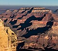
Shiva Temple (Grand Canyon)
| Shiva Temple | |
|---|---|
 South aspect, from South Rim | |
| Highest point | |
| Elevation | 7,646 ft (2,331 m)[1][2] |
| Prominence | 1,351 ft (412 m)[1] |
| Parent peak | Dragon Head (7,765 ft)[3] |
| Isolation | 2.65 mi (4.26 km)[3] |
| Coordinates | 36°10′04″N 112°09′49″W / 36.1678508°N 112.1635251°W[4] |
| Geography | |
| Country | United States |
| State | Arizona |
| County | Coconino |
| Protected area | Grand Canyon National Park |
| Parent range | Kaibab Plateau[1] Colorado Plateau |
| Topo map | USGS Shiva Temple |
| Climbing | |
| First ascent | Puebloans[5] |
| Easiest route | class 4 climbing[3] |
Shiva Temple is a 7,646-foot-elevation (2,331-meter) summit located in the Grand Canyon, in Coconino County of Arizona, US.[4] It is situated six miles north of Hopi Point overlook of the canyon's South Rim, about 2.5 miles southwest of North Rim's Tiyo Point, and two miles northwest of Isis Temple, where it towers 5,200 feet (1,600 meters) above the Colorado River. Shiva Temple is named for Shiva, the Hindu deity, destroyer of the universe. This name was applied by Clarence Dutton who began the tradition of naming geographical features in the Grand Canyon after mythological deities.[6] Dutton believed Shiva Temple was the largest, grandest, and most majestic of the Grand Canyon buttes, with a broad, level, forested top.[6] This mountain's name was officially adopted in 1906 by the U.S. Board on Geographic Names.[4]
In 1937, the American Museum of Natural History led explorations to Shiva Temple and Wotans Throne in the belief that these buttes, isolated for 100,000 years from the plateau, may have evolved new species. The scientists discovered Ancestral Puebloan dwellings, deer antlers, and an empty Kodak film box that had been left behind a month earlier by pioneer Emery Kolb, his daughter Edith, Ruth Stephens Baker, Gordon Berger, and Ralph White, but no new species.[7][8][9]
According to the Köppen climate classification system, Shiva Temple has a Cold semi-arid climate.[10]
Geology
[edit]
The top of Shiva Temple is composed of Permian Kaibab Limestone overlaying cream-colored, cliff-forming, Permian Coconino Sandstone.[11] The conspicuous band of sandstone, which is the third-youngest strata in the Grand Canyon, was deposited 265 million years ago as sand dunes. Below the Coconino Sandstone is slope-forming, reddish terraces of the Pennsylvanian-Permian Supai Group. Further down are strata of Mississippian Redwall Limestone, and finally the Cambrian Tonto Group.[12] Precipitation runoff from Shiva Temple drains south to the Colorado River via Trinity and Crystal Creeks.
Prominence – A plateau/tableland
[edit]The tableland plateau of Shiva Temple's prominence is made up of a forest of Ponderosa Pine; also pines, junipers, shrubs, and cacti.[13] The animals found in the survey expedition of 1937 were chipmunks, cottontail rabbits, pack rats, mice species, and rock squirrels.
Gallery
[edit]See also
[edit]References
[edit]- ^ a b c "Shiva Temple, Arizona". Peakbagger.com. Retrieved December 22, 2020.
- ^ USGS map, Shiva Temple quadrangle
- ^ a b c "Shiva Temple – 7,646' AZ". Lists of John. Retrieved December 22, 2020.
- ^ a b c "Shiva Temple". Geographic Names Information System. United States Geological Survey, United States Department of the Interior. Retrieved December 22, 2020.
- ^ Boye Lafayette De Mente, The Grand Canyon Answer Book! – Everything You Might Want to Know About the Grand Canyon and Then Some!, 2009, Cultural-Insight Books, ISBN 9780914778097, page 45.
- ^ a b Randy Moore and Kara Felicia Witt, The Grand Canyon: An Encyclopedia of Geography, History, and Culture, 2018, ABC-CLIO Publisher, page 150.
- ^ Randy Moore and Kara Felicia Witt, The Grand Canyon: An Encyclopedia of Geography, History, and Culture, 2018, ABC-CLIO Publisher, page 151.
- ^ May 29, 1994, Ruth Stephens Baker oral history interview with Karen Underhill, Grand Canyon National Park Museum Collection
- ^ Leavengood, Betty (October 2006). "Ruth Stephens Baker" (PDF). The O'l Pioneer: Quarterly Magazine of the Grand Canyon Historical Society. 17 (4): 3–4.
- ^ Peel, M. C.; Finlayson, B. L.; McMahon, T. A. (2007). "Updated world map of the Köppen−Geiger climate classification". Hydrol. Earth Syst. Sci. 11 (5): 1633. Bibcode:2007HESS...11.1633P. doi:10.5194/hess-11-1633-2007. ISSN 1027-5606.
- ^ N.H. Darton, Story of the Grand Canyon of Arizona, 1917, page 35.
- ^ William Kenneth Hamblin, Anatomy of the Grand Canyon: Panoramas of the Canyon's Geology, 2008, Grand Canyon Association Publisher, ISBN 9781934656013.
- ^ ”Shiva’s Temple”, Arizona, Nature 140 (613)1937 (1937 nature survey expedition) [1]
External links
[edit]- Weather forecast: National Weather Service
- American Museum of Natural History Grand Canyon Expedition account: American Alpine Journal
- Shiva Temple aerial photo


