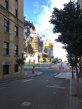
Sherwood Court, Perth
31°57′22″S 115°51′30″E / 31.9560°S 115.8583°E
Sherwood Court, Perth | |
|---|---|
 | |
| View from Sherwood Court toward constructions at Elizabeth Quay | |
 | |
| General information | |
| Type | Street |
| Length | 150 m (500 ft)[1] |
| Major junctions | |
| North end | St Georges Terrace |
| South end |
|
| Location(s) | |
| Suburb(s) | Perth |
Sherwood Court is a short sloping road between St Georges Terrace in Perth, Western Australia and The Esplanade with Allendale Square on the upper corner, and Lawson Apartments on the lower.
It sits across from London Court and allows pedestrian access between the central business district and The Esplanade and Perth foreshore. Its context has been taken into consideration in planning of the Perth foreshore development in that it is claimed that planned structures on The Esplanade will not block the view to Perth Water.[citation needed]
The images of former buildings on the St Georges Terrace corner provide context to the early architecture now lost.[2][3]
The Cecil Building at number 6 was frequently photographed,[4] as was Sherwood House.[5][6]
During the second world war, various offices of services relating to the war effort were housed in Sherwood Court[7] and before offices were made elsewhere, sections of the Perth Road Board were located there as well.[8][9] The Atlas Building, although facing the Esplanade, takes up the south western side of the street across from the Lawson Apartments.
The Allendale Square and Exchange Plaza buildings now take up considerable space of former structures in the street.
Intersections
[edit]| LGA | Location[1] | km | mi | Destinations | Notes |
|---|---|---|---|---|---|
| Perth | Perth | 0 | 0.0 | St Georges Terrace | Sherwood Court is one-way southbound; left turn from St Georges Terrace westbound onto Sherwood Court only |
| 0.15 | 0.093 | Traffic light controlled; Sherwood Court and Duchess Way are one-way southbound; no right turn from The Esplanade eastbound to Duchess Way or Sherwood Court to The Esplanade westbound | |||
| 1.000 mi = 1.609 km; 1.000 km = 0.621 mi | |||||
References
[edit]- ^ a b "Sherwood Court". Google Maps. Retrieved 24 November 2022.
- ^ "City Architecture". Western Mail. Perth. 27 November 1947. p. 126. Retrieved 18 June 2012 – via National Library of Australia.
- ^ http://www.pictureaustralia.org/apps/pictureaustralia?action=PASearch&mode=subject&complete1=true&attribute1=subject&term1=Sherwood+Court+%28Perth%2C+W.A.%29 [dead link]
- ^ "The French Consulate in the Cecil Building, Sherwood Court, Perth". Archived from the original on 21 April 2018.
- ^ Illustrations Ltd; HRRC (1950), Sherwood House, Sherwood Court, Perth, retrieved 18 October 2016
- ^ "Sherwood House, Sherwood Court". Archived from the original on 21 April 2018.
- ^ "Register Your Patriotism". The Daily News (Home ed.). Perth. 10 February 1942. p. 7. Retrieved 18 June 2012 – via National Library of Australia.
- ^ "Varied Activity". The West Australian. Perth. 17 January 1950. p. 17. Retrieved 18 June 2012 – via National Library of Australia.
- ^ Easton, Leonard A., 1915-; Stirling (W.A. : Municipality). Council. Public Relations Service (1900), The tale of one city : Perth Road Board, City of Stirling, Public Relations Service, retrieved 15 December 2019
{{citation}}: CS1 maint: multiple names: authors list (link) CS1 maint: numeric names: authors list (link)
