Sherwood–Carievale Border Crossing
| Sherwood–Carievale Border Crossing | |
|---|---|
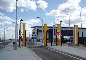
 US Border Inspection Station at Sherwood, North Dakota during its 2011 reconstruction | |
| Location | |
| Country | United States; Canada |
| Location | |
| Coordinates | 48°59′58″N 101°37′40″W / 48.999312°N 101.627871°W |
| Details | |
| Opened | 1930 |
| Hours | 9:00 AM-10:00 PM |
| Website www | |
The Sherwood–Carievale Border Crossing connects the towns of Sherwood, North Dakota and Carievale, Saskatchewan on the Canada–United States border. It is reached by North Dakota Highway 28 on the American side and Saskatchewan Highway 8 on the Canadian side. This is the easternmost border crossing in Saskatchewan; the Saskatchewan-Manitoba-North Dakota tripoint is located 19 kilometres (12 mi) east of this border crossing.
History
[edit]
Border inspection services were first conducted at this crossing in 1930. The US first built a permanent inspection station at the border in 1937. That brick veneer roadside border station was replaced by a wooden structure in 1981, and that facility was replaced by a large modern border station using Recovery Act funds in 2011.[1] Canada last replaced its border station in 1973.
See also
[edit]References
[edit]- ^ "30-Day Review of Spending by U.S. Customs and Border Protection under the American Recovery and Reinvestment Act for Construction of Land Ports of Entry" (PDF). Department of Homeland Security. October 23, 2009. Retrieved 10 December 2015.
